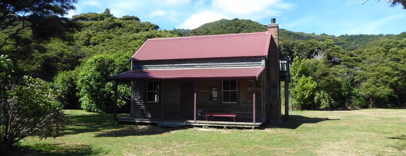
Whariwharangi Hut is the northernmost hut in Abel Tasman National Park. The hut is actually a historic farm homestead built in 1898, and is only a two minute walk from the beautiful Whariwharangi Bay. Whariwharangi Hut can be accessed relatively easily from Wainui Bay via Abel Tasman Coast Track and is a good option for an overnight tramp or day walk.
| Details | |
| Distances | 5.7 km Wainui Bay to Whariwharangi Hut; 6.6 km Whariwharangi Hut to Separation Point (return); 9.3 km Whariwharangi Hut to Tōtaranui |
| Time Required | 1 hr 45 min Wainui Bay to Whariwharangi Hut; 2 hr 30 min Whariwharangi Hut to Separation Point (return); 3 hr Whariwharangi Hut to Tōtaranui |
| Trail Type | Walking track |
| Physical Difficulty | Moderate |
| Uses | Walking and trail running |
| Direction | Either |
| Max Elevation | 200 m |
| Dog Access | Dogs are prohibited in Abel Tasman National Park |
If any layers fail to load, try clearing your cache and refreshing the page.
2 hr from Nelson | 30 min from Takaka
To get to Wainui Bay from Nelson, follow SH60 all the way to Takaka. In Takaka, turn right onto Abel Tasman Drive and follow it through Motupipi, Pohara and into Wainui Bay. On the eastern side of Wainui Bay, turn left onto McShane Road immediately before Tōtaranui Road switches to gravel at the start of the Pigeon Saddle climb. Follow McShane Road to the car park at the end. An information panel at the car park provides maps and information on times and distances.
From the car park at Wainui Bay, the smooth, Abel Tasman Coast Track climbs the hillside as a smooth, wide farm track, curving in and out of gullies. The surrounding hill country was largely cleared of vegetation for grazing at the end of the 19th century. It is only since the cessation of grazing in 1972 that the native vegetation has begun to recover. On the way up you’ll enjoy regular views northwest across Wainui Bay and Golden Bay. After 3 km you’ll reach the high point of the track (200 m), where there’s a track junction with Gibbs Hill Track. Continue straight along Coast Track, as it descends gently for 30 min into Whariwharangi Bay.
Whariwharangi Hut is positioned in a mowed grass clearing a couple of hundred metres from the beach of Whariwharangi Bay. The hut is actually a one-and-a-half storey homestead, built in 1898 by John Handcock and family, who leased the land off local maori and farmed the valley and surrounding ridges for 15 years. The last permanent inhabitants left in 1926, after which the homestead served as as stockman’s quarters until farming ended 46 years later (despite the poorness the granite soils for farming having been realised decades earlier). The homestead was renovated in 1980 to provide tramping accommodation. There is a large grassy area for camping next to the hut.
| Whariwharangi Hut | |
| Hut Type | Great Walk Hut |
| Capacity | 20 |
| Bookings | Required |
| Fee | Varies by season |
| Altitude | 5 m |
Whariwharangi Bay is a short walk from the hut. The kilometre-long beach has stunning golden sand and very clear water, and you’ll enjoy expansive views across Golden Bay toward Farewell Spit. Abel Tasman Coast Track continues along the back dunes of the beach, which are lined with macrocarpa. From here, the track turns inland and climbs up to a saddle on the ridge between Whariwharangi Bay and Mutton Cove. At the saddle there is a track junction where Separation Point Track branches to the left, while Abel Tasman Coast Track gently descends down to Anatakapau Bay (Tōtaranui is 2 hr from the latter).


Whariwharangi Hut is the northernmost hut in Abel Tasman National Park. The hut is actually a historic farm homestead built in 1898, and is only a two minute walk from the beautiful Whariwharangi Bay. Whariwharangi Hut can be accessed relatively easily from Wainui Bay via Abel Tasman Coast Track and is a good option for an overnight tramp or day walk.
| Details | |
| Distances | 5.7 km Wainui Bay to Whariwharangi Hut; 6.6 km Whariwharangi Hut to Separation Point (return); 9.3 km Whariwharangi Hut to Tōtaranui |
| Time Required | 1 hr 45 min Wainui Bay to Whariwharangi Hut; 2 hr 30 min Whariwharangi Hut to Separation Point (return); 3 hr Whariwharangi Hut to Tōtaranui |
| Trail Type | Walking track |
| Physical Difficulty | Moderate |
| Uses | Walking and trail running |
| Direction | Either |
| Max Elevation | 200 m |
| Dog Access | Dogs are prohibited in Abel Tasman National Park |
2 hr from Nelson | 30 min from Takaka
To get to Wainui Bay from Nelson, follow SH60 all the way to Takaka. In Takaka, turn right onto Abel Tasman Drive and follow it through Motupipi, Pohara and into Wainui Bay. On the eastern side of Wainui Bay, turn left onto McShane Road immediately before Tōtaranui Road switches to gravel at the start of the Pigeon Saddle climb. Follow McShane Road to the car park at the end. An information panel at the car park provides maps and information on times and distances.
From the car park at Wainui Bay, the smooth, Abel Tasman Coast Track climbs the hillside as a smooth, wide farm track, curving in and out of gullies. The surrounding hill country was largely cleared of vegetation for grazing at the end of the 19th century. It is only since the cessation of grazing in 1972 that the native vegetation has begun to recover. On the way up you’ll enjoy regular views northwest across Wainui Bay and Golden Bay. After 3 km you’ll reach the high point of the track (200 m), where there’s a track junction with Gibbs Hill Track. Continue straight along Coast Track, as it descends gently for 30 min into Whariwharangi Bay.
Whariwharangi Hut is positioned in a mowed grass clearing a couple of hundred metres from the beach of Whariwharangi Bay. The hut is actually a one-and-a-half storey homestead, built in 1898 by John Handcock and family, who leased the land off local maori and farmed the valley and surrounding ridges for 15 years. The last permanent inhabitants left in 1926, after which the homestead served as as stockman’s quarters until farming ended 46 years later (despite the poorness the granite soils for farming having been realised decades earlier). The homestead was renovated in 1980 to provide tramping accommodation. There is a large grassy area for camping next to the hut.
| Whariwharangi Hut | |
| Hut Type | Great Walk Hut |
| Capacity | 20 |
| Bookings | Required |
| Fee | Varies by season |
| Altitude | 5 m |
Whariwharangi Bay is a short walk from the hut. The kilometre-long beach has stunning golden sand and very clear water, and you’ll enjoy expansive views across Golden Bay toward Farewell Spit. Abel Tasman Coast Track continues along the back dunes of the beach, which are lined with macrocarpa. From here, the track turns inland and climbs up to a saddle on the ridge between Whariwharangi Bay and Mutton Cove. At the saddle there is a track junction where Separation Point Track branches to the left, while Abel Tasman Coast Track gently descends down to Anatakapau Bay (Tōtaranui is 2 hr from the latter).
Updated 26 January 2021