Pourangahau / Mt Robert (1421 m) is at the northern end of Robert Ridge in Nelson Lakes National Park. Pinchgut Track and Paddy’s Track form Mt Robert Circuit, one of the most accessible walks in the park and one that provides relatively easy access to the alpine environment and amazing views of Lake Rotoiti and St Arnaud. The circuit can be completed as a half-day walk, or as an overnight trip staying at Bushline Hut.
| Details | |
| Length | 8.4 km full circuit; 3.3 km car park to Robert Ridge junction via Pinchgut Track; 1.3 km Robert Ridge junction to Bushline Hut; 3.8 km Bushline Hut to car park via Paddy’s Track |
| Time Required | 3-4 hr full circuit |
| Trail Type | Tramping track/Poled route |
| Physical Difficulty | Moderate |
| Uses | Walking and trail running |
| Direction | Either |
| Start Elevation | 880 m (Mt Robert car park) |
| Max Elevation | 1430 m |
| Dog Access | Dogs are prohibited in Nelson Lakes National Park |
If any layers fail to load, try clearing your cache and refreshing the page.
This elevation profile should be considered approximate. Its accuracy is determined by the quality of data available.
1 hr 10 min from Nelson | 1 hr 20 min from Blenheim
The circuit starts and ends at Mt Robert car park, at the end of Mt Robert Road. The turnoff to Mt Robert Road is a 2 minute drive west of St Arnaud along State Highway 63. Mt Robert Road passes West Bay where there is parking and a campsite, crosses the source of the Buller River and reaches Mt Robert car park at 900 m elevation. There is a small shelter, toilets and a trail info panel at the car park. The car park is large but fills up on busy weekends. The road can be icy in winter, so take care when driving.
Nelson Lakes DOC Visitor Centre is located on View Road, St Arnaud. This is a good place to read up on the ecology, geology and history of St Arnaud and Nelson Lakes National Park, as well as check the latest alpine weather forecasts and speak to DOC staff about any warnings in place.
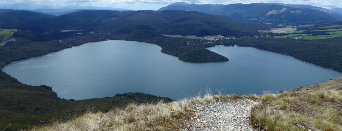
Beginning at Mt Robert car park, Pinchgut Track emerges from beech forest and zig-zags up the bare northern aspect of Mt Robert. The climb is unrelenting, though the gradient is never too steep and there are ample opportunities to stop and admire the view of the lake below. The original beech forest was razed in 1887 to allow sheep grazing, and though kānuka has reestablished on the lower half of the mountain, the top half remains treeless. The subsequent accelerated erosion is obvious, with large scree slopes descending down the entire face to the lake. The lack of shade means this can be a warm climb on sunny days.
The upper portion of the track zig-zags through beech forest, which becomes more stunted as you approach the treeline at 1360 m elevation. Above the treeline the gradient flattens out, as the well-worn track (now a poled route) follows the broad ridge south through snow tussock to Relax Shelter, which is a good place to put on warm layers if there’s a cold wind blowing. You will reach a junction where Paddy’s Track forks left (east) and Robert Ridge Route continues straight (south) along the ridge, eventually reaching Angelus Hut (9 km, 4-5 hrs away).
Paddy’s Track descends gently, with 1st Basin on the right and magnificent views of St Arnaud Range straight ahead. Bushline Hut is 1.3 km from the junction. The hut is well-positioned, enjoying all-day sun and allowing views northward toward St Arnaud township and the head of the lake.
| Bushline Hut | |
| Hut Type | Serviced Hut |
| Capacity | 14 bunks |
| Bookings | Not required; first in, first served |
| Fee | 1 Serviced Hut Ticket |
| Altitude | 1280 m |
Below Bushline Hut, Paddy’s Track zig-zags down the bare northern aspect of the mountain. After 1.8 km the track enters kānuka forest. Soon you will reach a link track through to Lakeside Track. The track continues over two large scree slides and ends at Mt Robert Road. From here it is an easy 400 m walk back to the car park.


Mt Robert Circuit is an alpine route, so proper preparation and care should be made to ensure a safe trip. This track reaches a high elevation and is extremely exposed above the treeline, so proper outdoor clothing is essential. Be sure to check the Nelson Lakes alpine weather forecast before you go (the DOC visitor centre at St Arnaud provides daily updates on the weather outlook). Take extra care in snowy or icy conditions as the steep sections toward the top of the range can be very slippery. Wasps are often in high numbers during summer; be sure to carry antihistamine if you are allergic.
See the Mountain Safety Council website, as well as their video below, for useful information on preparing for a Mt Robert trip.
Pourangahau / Mt Robert (1421 m) is at the northern end of Robert Ridge in Nelson Lakes National Park. Pinchgut Track and Paddy’s Track form Mt Robert Circuit, one of the most accessible walks in the park and one that provides relatively easy access to the alpine environment and amazing views of Lake Rotoiti and St Arnaud. The circuit can be completed as a half-day walk, or as an overnight trip staying at Bushline Hut.
| Details | |
| Length | 8.4 km full circuit; 3.3 km car park to Robert Ridge junction via Pinchgut Track; 1.3 km Robert Ridge junction to Bushline Hut; 3.8 km Bushline Hut to car park via Paddy’s Track |
| Time Required | 3-4 hr full circuit |
| Trail Type | Tramping track/Poled route |
| Physical Difficulty | Moderate |
| Uses | Walking and trail running |
| Direction | Either |
| Start Elevation | 880 m (Mt Robert car park) |
| Max Elevation | 1430 m |
| Dog Access | Dogs are prohibited in Nelson Lakes National Park |
1 hr 10 min from Nelson | 1 hr 20 min from Blenheim
The circuit starts and ends at Mt Robert car park, at the end of Mt Robert Road. The turnoff to Mt Robert Road is a 2 minute drive west of St Arnaud along State Highway 63. Mt Robert Road passes West Bay where there is parking and a campsite, crosses the source of the Buller River and reaches Mt Robert car park at 900 m elevation. There is a small shelter, toilets and a trail info panel at the car park. The car park is large but fills up on busy weekends. The road can be icy in winter, so take care when driving.
Nelson Lakes DOC Visitor Centre is located on View Road, St Arnaud. This is a good place to read up on the ecology, geology and history of St Arnaud and Nelson Lakes National Park, as well as check the latest alpine weather forecasts and speak to DOC staff about any warnings in place.
Beginning at Mt Robert car park, Pinchgut Track emerges from beech forest and zig-zags up the bare northern aspect of Mt Robert. The climb is unrelenting, though the gradient is never too steep and there are ample opportunities to stop and admire the view of the lake below. The original beech forest was razed in 1887 to allow sheep grazing, and though kānuka has reestablished on the lower half of the mountain, the top half remains treeless. The subsequent accelerated erosion is obvious, with large scree slopes descending down the entire face to the lake. The lack of shade means this can be a warm climb on sunny days.
The upper portion of the track zig-zags through beech forest, which becomes more stunted as you approach the treeline at 1360 m elevation. Above the treeline the gradient flattens out, as the well-worn track (now a poled route) follows the broad ridge south through snow tussock to Relax Shelter, which is a good place to put on warm layers if there’s a cold wind blowing. You will reach a junction where Paddy’s Track forks left (east) and Robert Ridge Route continues straight (south) along the ridge, eventually reaching Angelus Hut (9 km, 4-5 hrs away).
Paddy’s Track descends gently, with 1st Basin on the right and magnificent views of St Arnaud Range straight ahead. Bushline Hut is 1.3 km from the junction. The hut is well-positioned, enjoying all-day sun and allowing views northward toward St Arnaud township and the head of the lake.
| Bushline Hut | |
| Hut Type | Serviced Hut |
| Capacity | 14 bunks |
| Bookings | Not required; first in, first served |
| Fee | 1 Serviced Hut Ticket |
| Altitude | 1280 m |
Below Bushline Hut, Paddy’s Track zig-zags down the bare northern aspect of the mountain. After 1.8 km the track enters kānuka forest. Soon you will reach a link track through to Lakeside Track. The track continues over two large scree slides and ends at Mt Robert Road. From here it is an easy 400 m walk back to the car park.
Mt Robert Circuit is an alpine route, so proper preparation and care should be made to ensure a safe trip. This track reaches a high elevation and is extremely exposed above the treeline, so proper outdoor clothing is essential. Be sure to check the Nelson Lakes alpine weather forecast before you go (the DOC visitor centre at St Arnaud provides daily updates on the weather outlook). Take extra care in snowy or icy conditions as the steep sections toward the top of the range can be very slippery. Wasps are often in high numbers during summer; be sure to carry antihistamine if you are allergic.
See the Mountain Safety Council website, as well as their video below, for useful information on preparing for a Mt Robert trip.
Updated 20 February 2019