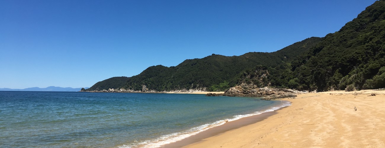
Abel Tasman Coast Track is the most popular of New Zealand’s Great Walks and is an international tramping destination. The track traces the coastline of Abel Tasman National Park between Mārahau and Wainui Bay, and is typically done in 3-5 days. The track is known for golden granite sand beaches, lush native coastal forest and its relatively easy grade. A large proportion of visitors to the national park use only small sections of the Coast Track for day walks, and availability of water taxis mean even the interior of the track can be visited in a single day.
| Details | |
| Distances | 54 km full length (excluding side tracks); 11.6 km Mārahau to Anchorage; 8.3 km Anchorage to Bark Bay; 12.8 km Bark Bay to Awaroa; 6.6 km Awaroa to Tōtaranui; 9.5 km Tōtaranui to Whariwharangi; 5.5 km Whariwharangi to Wainui Bay |
| Time Required | 3-5 days |
| Trail Type | Walking track |
| Physical Difficulty | Moderate |
| Uses | Walking and trail running |
| Direction | Either |
| Dog Access | Dogs are prohibited in Abel Tasman National Park |
| Note | Coast Track has tidal crossings at four locations that may affect your travel time; make sure you know the tide times before you leave. |
If any layers fail to load, try clearing your cache and refreshing the page.
Abel Tasman Inland Track
Walking and trail running
Gibbs Hill Circuit
Walking and trail running
Apple Tree Bay
Walking and trail running
Anchorage Hut
Walking and trail running
Separation Point
Walking and trail running
Whariwharangi Hut
Walking and trail running
Abel Tasman Coast Track is a relatively easy tramp by New Zealand standards. The track is smooth, wide and well-drained, and generally doesn’t require tramping boots (sneakers are OK). The climate is characterised by warm summers and mild winters, though you must always be prepared for cold, wet conditions. There are four inlet crossings that can only be crossed at low tide; of these three, Awaroa Inlet has no alternative high tide route. Wasps and sandflies can be a nuisance, so make sure you carry antihistamine and insect repellant.
Bookings are essential for staying in each of the four huts and 18 campsites along the track. DOC states that visitors attempting to stay in a hut or campsite without a booking will be charged a penalty fee or may be asked to leave the park. Campers are not permitted to use hut facilities.


Mārahau – 1 hr from Nelson
Mārahau is the southern gateway to Abel Tasman National Park. To get to the beginning of the Coast Track follow, the main (and only) road through Mārahau. A kilometre past the beachfront you’ll see signage indicating Abel Tasman Car Park on the right. There are toilets and an information kiosk with track information, tide timetables and warnings.
Kaiteriteri – 50 min from Nelson
Though the Coast Track begins at Mārahau, Kaiteriteri is the base for some water taxi operators as its steeper shoreline means it’s more accessible for larger boats.
Tōtaranui – 2 hr 30 min from Nelson
To get to Tōtaranui from Nelson, follow SH60 all the way to Tākaka. In Tākaka, turn right onto Abel Tasman Drive and follow it through Motupipi, Pohara and into Wainui Bay. On the eastern side of Wainui Bay, Tōtaranui Road (unsealed and windy) climbs over Pigeon Saddle to Tōtaranui. There is a DOC visitor centre here as well as a campground that is popular in summer.
Wainui Bay – 2 hr from Nelson
As above, follow SH60 all the way to Tākaka. In Tākaka, turn right onto Abel Tasman Drive and follow it through Motupipi, Pohara and into Wainui Bay. On the eastern side of Wainui Bay, turn left onto McShane Road immediately before Tōtaranui Road switches to gravel at the start of the Pigeon Saddle climb. Follow McShane Road to the car park at the end. An information panel at the car park provides maps and information on times and distances.
Awaroa Inlet – 2 hr 30 min from Nelson
There is road access to the western side of Awaroa Inlet. As above, follow Tōtaranui Road over Pigeon Saddle and turn right onto Awaroa Road. The latter descends to a car park at the side of the inlet.
A large proportion of the track’s users complete only small sections of it as part of days walks. This is made easy by the water taxi services that operate along the coastline between Kaiteriteri and Tōtaranui, which allow you to get dropped off and picked up between various points along the track.
| Distance | 11.6 km |
| Time Required | 4 hr |
Coast Track begins by crossing the tidal marsh of Sandy Bay via a causeway. At the other side the track officially enters Abel Tasman National Park, and heads through regenerating native bush along the coast. There are several access points to Porters Beach along here. After 30 min you’ll reach Tinline Bay campsite, where a short loop walk, Tinline Nature Walk, begins from behind the campsite. The track climbs gently and soon Inland Track branches on the left (Castle Rocks Hut is 4-5 hr away). The surrounding bush transitions to original native and the track sidles the hillside along the coast about 30 m above the water’s edge. About 1 hr from Mārahau you’ll reach the turnoff to Coquille Bay, which has a nice swimming beach and a DOC campsite.
Coast Track continues north along the coast, weaving in and out of lush gullies, with occasional gaps in the trees offering views down to the sea below. The track crosses Simonet Creek, and soon after you’ll reach the turnoff to Apple Tree Bay on the right.
Apple Tree Bay has a long, sandy beach that is great for swimming and has good views across Astrolabe Roadstead to Adele Island and Fisherman Island. There is a DOC camping area (bookings required), toilet, untreated water tap and a picnic table.
The track continues northward, weaving in and out of gullies on the hillside above the water’s edge. Side tracks to Stillwell Bay, Akersten Bay and Observation Cove branch off to the right. As you approach the head of the valley that leads to Anchorage, you’ll reach a track junction where a branch of Inland Track connects from the left, having descended from near Holyoake Shelter. Soon after, you’ll reach another junction, where a track drops down to the Torrent Bay inlet (bypassing Anchorage) and connecting to both the direct inlet crossing and the high tide route.
The track descends through scattered scrub toward Anchorage, where you’ll get good views north across Rākauroa/Torrent Bay. On the valley floor, the track heads around the edge of a wetland then heads along the beach to the hut. Anchorage Hut is a large modern hut, is set back from the beach in among campsite has capacity for 100 tents.
| Anchorage Hut | |
| Hut Type | Great Walk Hut |
| Capacity | 34 bunks |
| Bookings | Required |
You can take a side trip from Anchorage to Pitt Head and Te Pukatea Bay, which will take around 1 hr.
| Distances | 8.3 km (low tide route); 11.8 km (high tide route) |
| Time Required | 2 hr 40 min (low tide route); 3 hr 50 min (high tide route) |
Head west along the beachfront and into the bush at the orange triangle. You’ll reach the edge of Torrent Bay estuary, which can be crossed within 2 hours either side of low tide. At high tide, the estuary is too deep to cross, and you’ll have to take the high tide track around the edge. Follow the signpost to take the high tide track that heads to the left around the edge of the estuary.
An out-and-back side trip option is Cleopatra’s Pool, which is a natural pool in the Torrent River that is great for swimming. The turnoff is located on the high tide track, at the southwestern corner of the estuary. Allow 40 min return walking time for a return trip from the turnoff.
After crossing the estuary, Coast Track passes through the private properties of Torrent Bay Village, and on the far side climbs out of the bay and sidles the hillside inland of Frenchman Bay. The track descends into the valley of Falls River, crossing the latter via a 47 m suspension bridge, then followed the coast again above Sandfly Bay. You’ll pass a turnoff to Medlands Beach, a small cove that serves as the water taxi stop for Bark Bay, the latter being located a short distance further.
Bark Bay Hut is positioned amid large kanuka trees next to the tidal inlet behind the main beach.
| Bark Bay Hut | |
| Hut Type | Great Walk Hut |
| Capacity | 34 bunks |
| Bookings | Required |
| Distance | 12.8 km |
| Time Required | 4 hr 30 min |
Within 2 hours either side of high tide you can take the route straight across Bark Bay estuary. Otherwise, take high tide track which heads around the back of Bark Bay estuary where two bridges cross Huffam Stream and Waterfall Creek. The track then climbs to a saddle and sidles the hillside through manuka before descending to Tonga Quarry. Soon after you’ll Onetahuti Beach, which is the longest on-beach section of the track. At the northern end of the beach the track crosses the backdune swamp via a boardwalk, then climbs to Tonga Saddle. At the saddle an alternative non-DOC track branches off down to Awaroa Lodge and to Awaroa Beach, where the water taxi services the beach. The main track heads up Venture Creek gully then arrives at Awaroa Hut and campsite.
| Awaroa Hut | |
| Hut Type | Great Walk Hut |
| Capacity | 26 bunks |
| Bookings | Required |
| Distances | 6.6 km Awaroa Hut to Tōtaranui; 9.5 km Tōtaranui to Whariwharangi Hut via Anatakapau Bay |
| Time Required | 2 hr Awaroa Hut to Tōtaranui; 3 hr Tōtaranui to Whariwharangi Hut via Anatakapau Bay |
The tidal crossing across Awaroa Inlet begins immediately outside Awaroa Hut. The inlet can be crossed within 1hr 30 min before and 2 hr after low tide, though it may be impassable following very heavy rain. Note the crossing is approx. 1 km long and there is no alternative high tide track.
From the northern side of Awaroa Inlet, the track enters lush native bush and crosses a low saddle before descending to Waiharakeke Bay. It then climbs into the bush and drops down to Goat Bay. At the northern end the track climbs steeply above Skinner Point, where there is a lookout with views north along Tōtaranui Beach. The track then drops down to the shore and follows it to Tōtaranui.
There is no hut at Tōtaranui, only a visitor centre and campground. The campground is very popular in summer, mainly due to the fact Tōtaranui is the only interior part of the park that can be reached by road.
At the northern end of Tōtaranui, the track climbs over a saddle and drops down to Anapai Bay. It then climbs again and sidles above a rocky section of the coast before dropping again to Anatakapau Bay. Head along the beach towards the rocky headland that separates Anakatapau Bay from Mutton Cove. Here Coast Track heads inland (Separation Point circuit continues north to Mutton Cove), climbing the gully behind Mutton Cove and crossing a saddle on the ridge that bounds Whariwharangi Bay. The track descends down to the long, sweeping beach of Whariwharangi Bay, which is lined with macrocarpa. Whariwharangi Hut is located a couple of minutes inland from the beach.
| Whariwharangi Hut | |
| Hut Type | Great Walk Hut |
| Capacity | 20 bunks |
| Bookings | Required |
| Distances | 5.5 km Whariwharangi Hut to Wainui Bay |
| Time Required | 1 hr 30 min Whariwharangi Hut to Wainui Bay |
From the hut the track heads inland and climbs to a saddle overlooking Wainui Bay, which at 200 m elevation is the highest point on the Coast Track. Here, there is a junction with Gibbs Hill Track, which heads south to Tōtaranui and Pigeon Saddle. Coast Track descends the hillside as a smooth, wide farm track, curving in and out of gullies. The surrounding hill country was largely cleared of vegetation for grazing at the end of the 19th century. It is only since the cessation of grazing in 1972 that the native vegetation has begun to recover. On the way up you’ll enjoy regular views northwest across Wainui Bay and Golden Bay. You’ll reach the northern end of Coast Track at the Wainui Bay car park.
Abel Tasman Coast Track is the most popular of New Zealand’s Great Walks and is an international tramping destination. The track traces the coastline of Abel Tasman National Park between Mārahau and Wainui Bay, and is typically done in 3-5 days. The track is known for golden granite sand beaches, lush native coastal forest and its relatively easy grade. A large proportion of visitors to the national park use only small sections of the Coast Track for day walks, and availability of water taxis mean even the interior of the track can be visited in a single day.
| Details | |
| Distances | 54 km full length (excluding side tracks); 11.6 km Mārahau to Anchorage; 8.3 km Anchorage to Bark Bay; 12.8 km Bark Bay to Awaroa; 6.6 km Awaroa to Tōtaranui; 9.5 km Tōtaranui to Whariwharangi; 5.5 km Whariwharangi to Wainui Bay |
| Time Required | 3-5 days |
| Trail Type | Walking track |
| Physical Difficulty | Moderate |
| Uses | Walking and trail running |
| Direction | Either |
| Dog Access | Dogs are prohibited in Abel Tasman National Park |
| Note | Coast Track has tidal crossings at four locations that may affect your travel time; make sure you know the tide times before you leave. |
Mārahau – 1 hr from Nelson
Mārahau is the southern gateway to Abel Tasman National Park. To get to the beginning of the Coast Track follow, the main (and only) road through Mārahau. A kilometre past the beachfront you’ll see signage indicating Abel Tasman Car Park on the right. There are toilets and an information kiosk with track information, tide timetables and warnings.
Kaiteriteri – 50 min from Nelson
Though the Coast Track begins at Mārahau, Kaiteriteri is the base for some water taxi operators as its steeper shoreline means it’s more accessible for larger boats.
Tōtaranui – 2 hr 30 min from Nelson
To get to Tōtaranui from Nelson, follow SH60 all the way to Tākaka. In Tākaka, turn right onto Abel Tasman Drive and follow it through Motupipi, Pohara and into Wainui Bay. On the eastern side of Wainui Bay, Tōtaranui Road (unsealed and windy) climbs over Pigeon Saddle to Tōtaranui. There is a DOC visitor centre here as well as a campground that is popular in summer.
Wainui Bay – 2 hr from Nelson
As above, follow SH60 all the way to Tākaka. In Tākaka, turn right onto Abel Tasman Drive and follow it through Motupipi, Pohara and into Wainui Bay. On the eastern side of Wainui Bay, turn left onto McShane Road immediately before Tōtaranui Road switches to gravel at the start of the Pigeon Saddle climb. Follow McShane Road to the car park at the end. An information panel at the car park provides maps and information on times and distances.
Awaroa Inlet – 2 hr 30 min from Nelson
There is road access to the western side of Awaroa Inlet. As above, follow Tōtaranui Road over Pigeon Saddle and turn right onto Awaroa Road. The latter descends to a car park at the side of the inlet.
A large proportion of the track’s users complete only small sections of it as part of days walks. This is made easy by the water taxi services that operate along the coastline between Kaiteriteri and Tōtaranui, which allow you to get dropped off and picked up between various points along the track.
| Distances | 11.6 km |
| Time Required | 4 hr |
Coast Track begins by crossing the tidal marsh of Sandy Bay via a causeway. At the other side the track officially enters Abel Tasman National Park, and heads through regenerating native bush along the coast. There are several access points to Porters Beach along here. After 30 min you’ll reach Tinline Bay campsite, where a short loop walk, Tinline Nature Walk, begins from behind the campsite. The track climbs gently and soon Inland Track branches on the left (Castle Rocks Hut is 4-5 hr away). The surrounding bush transitions to original native and the track sidles the hillside along the coast about 30 m above the water’s edge. About 1 hr from Mārahau you’ll reach the turnoff to Coquille Bay, which has a nice swimming beach and a DOC campsite.
Coast Track continues north along the coast, weaving in and out of lush gullies, with occasional gaps in the trees offering views down to the sea below. The track crosses Simonet Creek, and soon after you’ll reach the turnoff to Apple Tree Bay on the right.
Apple Tree Bay has a long, sandy beach that is great for swimming and has good views across Astrolabe Roadstead to Adele Island and Fisherman Island. There is a DOC camping area (bookings required), toilet, untreated water tap and a picnic table.
The track continues northward, weaving in and out of gullies on the hillside above the water’s edge. Side tracks to Stillwell Bay, Akersten Bay and Observation Cove branch off to the right. As you approach the head of the valley that leads to Anchorage, you’ll reach a track junction where a branch of Inland Track connects from the left, having descended from near Holyoake Shelter. Soon after, you’ll reach another junction, where a track drops down to the Torrent Bay inlet (bypassing Anchorage) and connecting to both the direct inlet crossing and the high tide route.
The track descends through scattered scrub toward Anchorage, where you’ll get good views north across Rākauroa/Torrent Bay. On the valley floor, the track heads around the edge of a wetland then heads along the beach to the hut. Anchorage Hut is a large modern hut, is set back from the beach in among campsite has capacity for 100 tents.
| Anchorage Hut | |
| Hut Type | Great Walk Hut |
| Capacity | 34 bunks |
| Bookings | Required |
You can take a side trip from Anchorage to Pitt Head and Te Pukatea Bay, which will take around 1 hr.
| Distances | 8.3 km (low tide route); 11.8 km (high tide route) |
| Time Required | 2 hr 40 min (low tide route); 3 hr 50 min (high tide route) |
Head west along the beachfront and into the bush at the orange triangle. You’ll reach the edge of Torrent Bay estuary, which can be crossed within 2 hours either side of low tide. At high tide, the estuary is too deep to cross, and you’ll have to take the high tide track around the edge. Follow the signpost to take the high tide track that heads to the left around the edge of the estuary.
An out-and-back side trip option is Cleopatra’s Pool, which is a natural pool in the Torrent River that is great for swimming. The turnoff is located on the high tide track, at the southwestern corner of the estuary. Allow 40 min return walking time for a return trip from the turnoff.
After crossing the estuary, Coast Track passes through the private properties of Torrent Bay Village, and on the far side climbs out of the bay and sidles the hillside inland of Frenchman Bay. The track descends into the valley of Falls River, crossing the latter via a 47 m suspension bridge, then followed the coast again above Sandfly Bay. You’ll pass a turnoff to Medlands Beach, a small cove that serves as the water taxi stop for Bark Bay, the latter being located a short distance further.
Bark Bay Hut is positioned amid large kanuka trees next to the tidal inlet behind the main beach.
| Bark Bay Hut | |
| Hut Type | Great Walk Hut |
| Capacity | 34 bunks |
| Bookings | Required |
| Distance | 12.8 km |
| Time Required | 4 hr 30 min |
Within 2 hours either side of high tide you can take the route straight across Bark Bay estuary. Otherwise, take high tide track which heads around the back of Bark Bay estuary where two bridges cross Huffam Stream and Waterfall Creek. The track then climbs to a saddle and sidles the hillside through manuka before descending to Tonga Quarry. Soon after you’ll Onetahuti Beach, which is the longest on-beach section of the track. At the northern end of the beach the track crosses the backdune swamp via a boardwalk, then climbs to Tonga Saddle. At the saddle an alternative non-DOC track branches off down to Awaroa Lodge and to Awaroa Beach, where the water taxi services the beach. The main track heads up Venture Creek gully then arrives at Awaroa Hut and campsite.
| Awaroa Hut | |
| Hut Type | Great Walk Hut |
| Capacity | 26 bunks |
| Bookings | Required |
| Distances | 6.6 km Awaroa Hut to Tōtaranui; 9.5 km Tōtaranui to Whariwharangi Hut via Anatakapau Bay |
| Time Required | 2 hr Awaroa Hut to Tōtaranui; 3 hr Tōtaranui to Whariwharangi Hut via Anatakapau Bay |
The tidal crossing across Awaroa Inlet begins immediately outside Awaroa Hut. The inlet can be crossed within 1hr 30 min before and 2 hr after low tide, though it may be impassable following very heavy rain. Note the crossing is approx. 1 km long and there is no alternative high tide track.
From the northern side of Awaroa Inlet, the track enters lush native bush and crosses a low saddle before descending to Waiharakeke Bay. It then climbs into the bush and drops down to Goat Bay. At the northern end the track climbs steeply above Skinner Point, where there is a lookout with views north along Tōtaranui Beach. The track then drops down to the shore and follows it to Tōtaranui.
There is no hut at Tōtaranui, only a visitor centre and campground. The campground is very popular in summer, mainly due to the fact Tōtaranui is the only interior part of the park that can be reached by road.
At the northern end of Tōtaranui, the track climbs over a saddle and drops down to Anapai Bay. It then climbs again and sidles above a rocky section of the coast before dropping again to Anatakapau Bay. Head along the beach towards the rocky headland that separates Anakatapau Bay from Mutton Cove. Here Coast Track heads inland (Separation Point circuit continues north to Mutton Cove), climbing the gully behind Mutton Cove and crossing a saddle on the ridge that bounds Whariwharangi Bay. The track descends down to the long, sweeping beach of Whariwharangi Bay, which is lined with macrocarpa. Whariwharangi Hut is located a couple of minutes inland from the beach.
| Whariwharangi Hut | |
| Hut Type | Great Walk Hut |
| Capacity | 20 bunks |
| Bookings | Required |
| Distances | 5.5 km Whariwharangi Hut to Wainui Bay |
| Time Required | 1 hr 30 min Whariwharangi Hut to Wainui Bay |
From the hut the track heads inland and climbs to a saddle overlooking Wainui Bay, which at 200 m elevation is the highest point on the Coast Track. Here, there is a junction with Gibbs Hill Track, which heads south to Tōtaranui and Pigeon Saddle. Coast Track descends the hillside as a smooth, wide farm track, curving in and out of gullies. The surrounding hill country was largely cleared of vegetation for grazing at the end of the 19th century. It is only since the cessation of grazing in 1972 that the native vegetation has begun to recover. On the way up you’ll enjoy regular views northwest across Wainui Bay and Golden Bay. You’ll reach the northern end of Coast Track at the Wainui Bay car park.
Abel Tasman Coast Track is a relatively easy tramp by New Zealand standards. The track is smooth, wide and well-drained, and generally doesn’t require tramping boots (sneakers are OK). The climate is characterised by warm summers and mild winters, though you must always be prepared for cold, wet conditions. There are four inlet crossings that can only be crossed at low tide; of these three, Awaroa Inlet has no alternative high tide route. Wasps and sandflies can be a nuisance, so make sure you carry antihistamine and insect repellant.
Bookings are essential for staying in each of the four huts and 18 campsites along the track. DOC states that visitors attempting to stay in a hut or campsite without a booking will be charged a penalty fee or may be asked to leave the park. Campers are not permitted to use hut facilities.
Apple Tree Bay
Walking and trail running
Anchorage Hut
Walking and trail running
Separation Point
Walking and trail running
Whariwharangi Hut
Walking and trail running
Abel Tasman Inland Track
Walking and trail running
Gibbs Hill Circuit
Walking, trail running and MTB
Updated 12 November 2021