Ben Nevis (1619 m) is a peak in Mt Richmond Forest Park, southwest of Nelson. Beginning in Wairoa Valley, Ben Nevis Track climbs along Gibbs Spur to the trig at the summit and is a half-day return walk. The term ‘Ben’ means mountain in Scottish Gaelic. ‘Ben Nevis’ is an Anglicisation of ‘Beinn Nibheis’, which is commonly translated to ‘mountain of the heaven’. This particular Ben Nevis is second highest of the three peaks in New Zealand that share the name.
| Details | |
| Length | 9.6 km return |
| Time Required | 4-5 hr return |
| Trail Type | Tramping track |
| Physical Difficulty | Hard |
| Uses | Walking and trail running |
| Direction | Return (up and down) |
| Start Elevation | 820 m |
| Max Elevation | 1619 m |
| Dog Access | Permit required for Mt Richmond Forest Park; see local DOC office |
If any layers fail to load, try clearing your cache and refreshing the page.
This elevation profile should be considered approximate. Its accuracy is determined by the quality of data available.
Ben Nevis Track does not connect to any other official tracks. Experienced parties may continue along the ridge to Mt Ellis and Te Araroa Trail, though this route is unmaintained and highly exposed.
1 hr from Nelson
From Nelson, head south along State Highway 6 to Wakefield, turn left onto Pitfure Rd, then left again onto Edward St. Turn right onto Church Valley Rd, which becomes Pig Valley Rd and is unsealed from here on. Continue straight at the intersection with Wairoa Gorge Rd, and follow the latter for 5 km until Old Mill Rd forks on the left, bridging Wairoa River Right Branch. Head up Old Mill Rd for 2.7 km and then turn right onto Ben Nevis Rd as it begins up the hillside into pine forest (look for the DOC sign on the left).
Ben Nevis Road is steep, rough and windy, so it is suitable for 4WD vehicles only. There are a few forestry roads that branch off, so pay attention to the orange DOC markers that indicate the correct route. A the top of the road you’ll reach a gate, where there is a small area to park your vehicle. Walk past the gate and follow the steep forestry track to the edge of the forestry block, where you’ll see a DOC sign indicating the start of Ben Nevis Track.
Check DOC’s Mt Richmond Forest Park access page for closures before you go. Logging and high fire risk will close access.
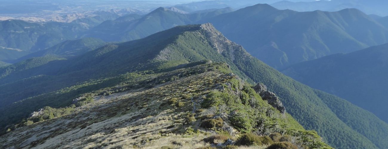
Beginning at the DOC sign at the end of the road, Ben Nevis Track emerges from the forestry block and climbs up Gibbs Spur through open scrub and douglas fir trees, before entering beech forest. After 1.6 km a meadow is reached, where the track climbs up around rocky crags, which drop steeply to the east into Wairoa River valley. The track re-enters beech forest and is undulating for another kilometre until the tree line at 1350 m elevation.
The track continues winding upwards through tussock and rocky outcrops, with cairns marking the way. The trig at the summit is positioned on the crest of the range at 1619 m elevation. Here you will enjoy expansive views north and west over the Tasman Bay hinterland, and south toward the distinctive hue of Red Hill.
Return the way you came.
From the trig at the summit an unmarked route continues southwest along the range to connect with Te Araroa Trail near Mt Ellis (approx. 6 km away), creating connections to Hunters Hut and Top Wairoa Hut. Travel along the range is straight-forward for experienced trampers in clear, snow-free conditions. Expect the range traverse to take at least 2 hours.
Ben Nevis is an alpine environment, so proper preparation and care should be made to ensure a safe trip. The track reaches a high elevation and is exposed above the tree line, so proper outdoor clothing is essential. You must always be prepared for freezing conditions and take extreme care if snow and ice and are present. Do not rely on the Nelson weather forecast as the alpine conditions in Mt Richmond Forest Park are likely to be drastically different. Make sure you carry plenty of water with you as there are no water sources on the way up.
See the Mountain Safety Council website for useful information on preparing for the outdoors.


Ben Nevis (1619 m) is a peak in Mt Richmond Forest Park, southwest of Nelson. Beginning in Wairoa Valley, Ben Nevis Track climbs along Gibbs Spur to the trig at the summit and is a half-day return walk. The term ‘Ben’ means mountain in Scottish Gaelic. ‘Ben Nevis’ is an Anglicisation of ‘Beinn Nibheis’, which is commonly translated to ‘mountain of the heaven’. This particular Ben Nevis is second highest of the three peaks in New Zealand that share the name.
| Details | |
| Length | 9.6 km return |
| Time Required | 4-5 hr return |
| Trail Type | Tramping track |
| Physical Difficulty | Hard |
| Uses | Walking and trail running |
| Direction | Return (up and down) |
| Start Elevation | 820 m |
| Max Elevation | 1619 m |
| Dog Access | Permit required for Mt Richmond Forest Park; see local DOC office |
This elevation profile should be considered approximate. Its accuracy is determined by the quality of data available.
1 hr from Nelson
From Nelson, head south along State Highway 6 to Wakefield, turn left onto Pitfure Rd, then left again onto Edward St. Turn right onto Church Valley Rd, which becomes Pig Valley Rd and is unsealed from here on. Continue straight at the intersection with Wairoa Gorge Rd, and follow the latter for 5 km until Old Mill Rd forks on the left, bridging Wairoa River Right Branch. Head up Old Mill Rd for 2.7 km and then turn right onto Ben Nevis Rd as it begins up the hillside into pine forest (look for the DOC sign on the left).
Ben Nevis Road is steep, rough and windy, so it is suitable for 4WD vehicles only. There are a few forestry roads that branch off, so pay attention to the orange DOC markers that indicate the correct route. A the top of the road you’ll reach a gate, where there is a small area to park your vehicle. Walk past the gate and follow the steep forestry track to the edge of the forestry block, where you’ll see a DOC sign indicating the start of Ben Nevis Track.
Check DOC’s Mt Richmond Forest Park access page for closures before you go. Logging and high fire risk will close access.
Beginning at the DOC sign at the end of the road, Ben Nevis Track emerges from the forestry block and climbs up Gibbs Spur through open scrub and douglas fir trees, before entering beech forest. After 1.6 km a meadow is reached, where the track climbs up around rocky crags, which drop steeply to the east into Wairoa River valley. The track re-enters beech forest and is undulating for another kilometre until the tree line at 1350 m elevation.
The track continues winding upwards through tussock and rocky outcrops, with cairns marking the way. The trig at the summit is positioned on the crest of the range at 1619 m elevation. Here you will enjoy expansive views north and west over the Tasman Bay hinterland, and south toward the distinctive hue of Red Hill.
Return the way you came.
From the trig at the summit an unmarked route continues southwest along the range to connect with Te Araroa Trail near Mt Ellis (approx. 6 km away), creating connections to Hunters Hut and Top Wairoa Hut. Travel along the range is straight-forward for experienced trampers in clear, snow-free conditions. Expect the range traverse to take at least 2 hours.
Ben Nevis is an alpine environment, so proper preparation and care should be made to ensure a safe trip. The track reaches a high elevation and is exposed above the tree line, so proper outdoor clothing is essential. You must always be prepared for freezing conditions and take extreme care if snow and ice and are present. Do not rely on the Nelson weather forecast as the alpine conditions in Mt Richmond Forest Park are likely to be drastically different. Make sure you carry plenty of water with you as there are no water sources on the way up.
See the Mountain Safety Council website for useful information on preparing for the outdoors.
Ben Nevis Track does not connect to any other official tracks. Experienced parties may continue along the ridge to Mt Ellis and Te Araroa Trail, though this route is unmaintained and highly exposed.
Updated 26 October 2021