Takorika (721 m) is a hill immediately west of Havelock. A network of tracks provide several options for reaching the summit. Takorika’s eastern slopes form the catchment of the town’s former water supply and feature some nice native bush and two waterfalls.
| Details | |
| Length | 6.7 km return to car park (most direct route) |
| Time Required | 3-4 hr |
| Trail Type | Walking track/Tramping track |
| Physical Difficulty | Moderate |
| Uses | Walking, trail running and MTB (on specific tracks only) |
| Direction | Either |
| Start Elevation | 50 m |
| Max Elevation | 721 m |
If any layers fail to load, try clearing your cache and refreshing the page.
Wilson Road
Trail running and MTB
1 hr from Nelson | 30 min from Blenheim
Havelock is an hour-long drive along State Highway 6 from Nelson, via Whangamoa and Rai saddles. From Blenheim it is a 30 min drive, also along State Highway 6.
Takorika Track is accessed from Lawrence St, which is a side-street off of SH6 in Havelock. Where Lawrence St turns south to become Takorika St, there is a small grassed parking area on the right with a hand-painted map showing the various tracks.
The tracks are not located within DOC conservation land and are primarily maintained by local volunteers Camilla and John. They have made neat hand-painted signs that provide clear directions along all tracks on the hill. They also maintain a trapping network that is helping to increase native bird numbers.
There are several options for climbing the summit depending on your fitness and ability (see map).
A 4WD road climbs from the end of Lawrence St. After a few hundred metres you’ll reach a junction where Main Track heads uphill to the left and Waterfall Track heads to the right (past the town dam).
Heading up Waterfall Track, the first waterfall is located a short distance past the dam, along an easy-grade track. A sign warns that Waterfall Track above here is ‘unformed’; if you’re fit and OK with a bit of a rough scramble, Waterfall Track is the best option for the uphill leg, otherwise go back the way you came and take Main Track for a gentler ascent.
Waterfall Track climbs up a gully alongside the unnamed stream that feeds the waterfall and once provided Havelock’s water supply. The gully definitely has the most attractive, intact bush of anywhere else on the Havelock side of Takorika, though it is steep and a little rough. Ferns, supplejack and kiekie give it a ‘jungle’ feel. A second waterfall of similar height is located about 20 min further up. The top end of Waterfall Track connects with Lower Track, where you can turn left to connect to Main Track. Given how steep it is, Waterfall Track is best done in the uphill direction.
Lower Track sidles the hill eastward to connect to Main Track, where you will turn right and climb a little further to the junction with Lookout Track. Lookout Track branches to the left and leads to a set of boulders that allow clear views down toward Havelock (and rival the views of the summit). A little further on, the upper end of Lookout Track connects to Escarpment Track (where you can also turn right to get back Main Track). As the name suggests, Escarpment Track climbs on the upward side of a rocky escarpment and approaches the summit from the southeast, allowing good views down the valley to the south. The track briefly enters beech forest and skirts the boundary of Mt Richmond Forest Park before reaching the summit.
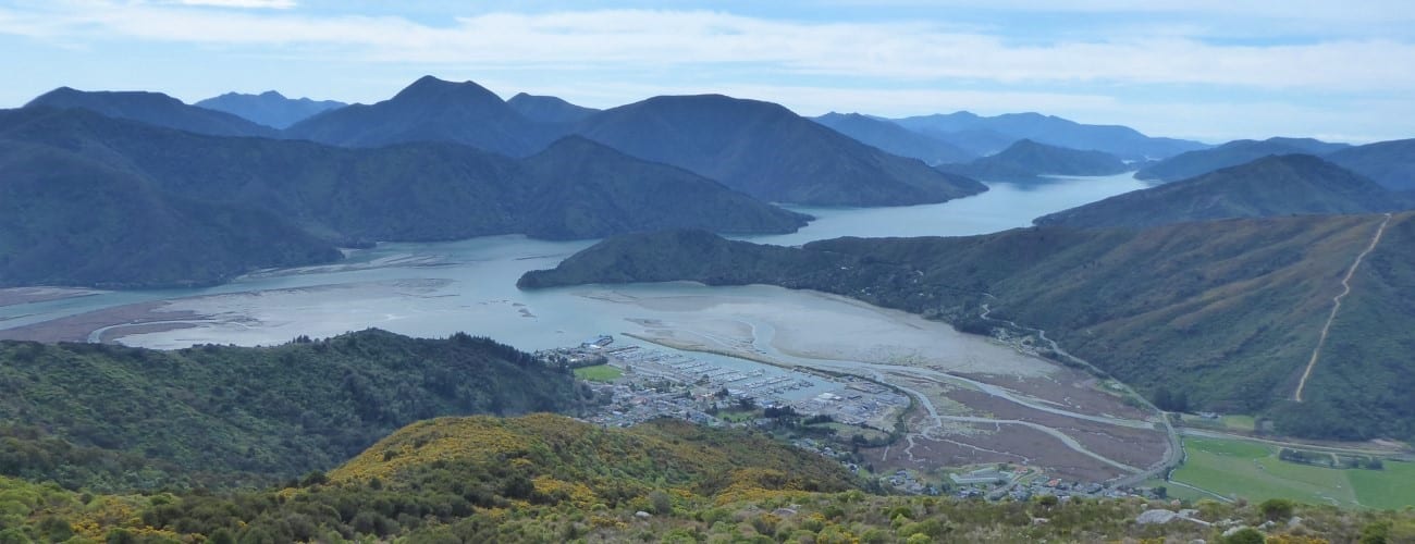
The summit hosts a trig point and several telecommunications towers. A wooden platform provides a good spot to sit and admire the views of Havelock, Pelorus Sound and the steep forested ranges that surround them.
On the return leg, the most straight-forward way down is via Main Track, which zig-zags all the way to the bottom through scruffy regenerating native bush.


Takorika (721 m) is a hill immediately west of Havelock. A network of tracks provide several options for reaching the summit. Takorika’s eastern slopes form the catchment of the town’s formr water supply and feature some nice native bush and two waterfalls.
| Details | |
| Length | 6.7 km return to car park (most direct route) |
| Time Required | 3-4 hr |
| Trail Type | Walking track/Tramping track |
| Physical Difficulty | Moderate |
| Uses | Walking, trail running and MTB (on specific tracks only) |
| Direction | Either |
| Start Elevation | 50 m |
| Max Elevation | 721 m |
60 min from Nelson | 30 min from Blenheim
Havelock is an hour-long drive along State Highway 6 from Nelson, via Whangamoa and Rai saddles. From Blenheim it is a 30 min drive, also along State Highway 6.
Takorika Track is accessed from Lawrence St, which is a side-street off of SH6 in Havelock. Where Lawrence St turns south to become Takorika St, there is a small grassed parking area on the right with a hand-painted map showing the various tracks.
The tracks are not located within DOC conservation land and are primarily maintained by local volunteers Camilla and John. They have made neat hand-painted signs that provide clear directions along all tracks on the hill. They also maintain a trapping network that is helping to increase native bird numbers.
There are several options for climbing the summit depending on your fitness and ability (see map).
A 4WD road climbs from the end of Lawrence St. After a few hundred metres you’ll reach a junction where Main Track heads uphill to the left and Waterfall Track heads to the right (past the town dam).
Heading up Waterfall Track, the first waterfall is located a short distance past the dam, along an easy-grade track. A sign warns that Waterfall Track above here is ‘unformed’; if you’re fit and OK with a bit of a rough scramble, Waterfall Track is the best option for the uphill leg, otherwise go back the way you came and take Main Track for a gentler ascent.
Waterfall Track climbs up a gully alongside the unnamed stream that feeds the waterfall and once provided Havelock’s water supply. The gully definitely has the most attractive, intact bush of anywhere else on the Havelock side of Takorika, though it is steep and a little rough. Ferns, supplejack and kiekie give it a ‘jungle’ feel. A second waterfall of similar height is located about 20 min further up. The top end of Waterfall Track connects with Lower Track, where you can turn left to connect to Main Track. Given how steep it is, Waterfall Track is best done in the uphill direction.
Lower Track sidles the hill eastward to connect to Main Track, where you will turn right and climb a little further to the junction with Lookout Track. Lookout Track branches to the left and leads to a set of boulders that allow clear views down toward Havelock (and rival the views of the summit). A little further on, the upper end of Lookout Track connects to Escarpment Track (where you can also turn right to get back Main Track). As the name suggests, Escarpment Track climbs on the upward side of a rocky escarpment and approaches the summit from the southeast, allowing good views down the valley to the south. The track briefly enters beech forest and skirts the boundary of Mt Richmond Forest Park before reaching the summit.
The summit hosts a trig point and several telecommunications towers. A wooden platform provides a good spot to sit and admire the views of Havelock, Pelorus Sound and the steep forested ranges that surround them.
On the return leg, the most straight-forward way down is via Main Track, which zig-zags all the way to the bottom through scruffy regenerating native bush.
Wilson Road
Trail running and MTB
Updated 26 November 2020