Beeby’s Knob (1442 m) is a peak in the southwestern corner of Mt Richmond Forest Park, near St Arnaud. A return trip to the summit is a good half-day walk or MTB ride, and Beeby’s Hut provides the option for overnight stays. There are two access routes; a walking track, and a 4WD road/MTB singletrack, the latter providing the option to ride.
| Details | |
| Distances (via walking track) | 6 km one way to summit; 7.8 km one way to Beeby’s Hut |
| Distances (via Wots Up Doc) | 8.4 km one way to summit; 10.2 km one way to Beeby’s Hut |
| Time Required | 3-4 hr one way to summit; 4-5 hr one way to Beeby’s Hut (walking) |
| Trail Type | Tramping track/4WD road |
| Physical Difficulty | Hard |
| Uses | Walking, trail running and MTB |
| Direction | Either |
| Start Elevation | 610 m (walking track) or 710 m (4WD road) |
| Max Elevation | 1442 m |
| Dog Access | Permit required for Mt Richmond Forest Park; see local DOC office |
If any layers fail to load, try clearing your cache and refreshing the page.
This elevation profile should be considered approximate. Its accuracy is determined by the quality of data available.
1 hr from Nelson
There are two ways to reach the summit of Beeby’s Knob and Beeby’s Hut; a walking track and a 4WD road/MTB single track. The walking track is suitable for walking only, while the 4WD/singletrack is suitable for both walking and MTB.
Beeby’s Knob Walking Track: Korere-Tophouse Road
The track starts at a small car park on the left side (if you’re heading south) of Korere-Tophouse Road, 62 km south of Nelson (6.9 km south of Kikiwa and 6.5 km north of the State Highway 63 junction). The turnoff is in a tricky location on a sweeping left bend in the road. Look for the DOC sign and make a sharp left turn onto the gravel road that leads to the car park. There is a closed gate (unlocked) that you will need to open.
Beeby’s Knob 4WD Road and Wots Up Doc: Tophouse Road
Turn left onto Tophouse Rd and follow it for 3.3 km until you you see the green DOC sign on the left. There is no car park but there is space on either side of the gravel road to fit your car.
Beeby’s Walking Track
From the car park, the Beeby’s Walking Track climbs and sidles the hillside through beech forest, reaching a wide saddle where beautiful beech forest and mossy logs cover the forest floor. The track steepens as it climbs the side of broad spur, and once on the crest, the gradient lessens. As the track progresses up the spur the beech trees gradually become shorter and thinner.
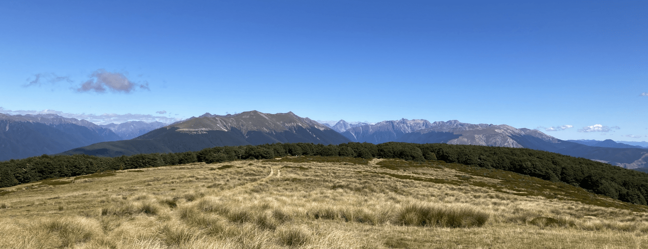
The track connects with Beeby’s 4WD road at the top of range. Turn left here and follow the road as it soon reaches the turnoff to Maitland Ridge Track at the tree line. The road continues along the range through open tussock and alpine herbs. The summit is 1.8 km beyond the Maitland Ridge turnoff. It is not signposted, though you will see the trig and a group of transmitters on top a rounded knob, which is a short deviation off the road.
The 4WD road continues for quite a distance along the range. Beeby’s Hut is a further 1.8 km beyond the summit, located alongside the bush edge on the eastern side of the range.
| Beeby’s Hut | |
| Hut Type | Standard Hut |
| Capacity | 6 bunks |
| Bookings | Not required; first in, first served |
| Fee | 1 Standard Hut Ticket |
| Altitude | 1320 m |
Beeby’s Knob is a highly-exposed alpine environment, so proper preparation and care is essential to ensure a safe trip. Check the Nelson Lakes alpine weather forecast before you go; do not rely on the weather forecast for Nelson or Blenheim, as the alpine weather in the Richmond Ranges are likely to be very different. Make sure you carry plenty of water with you as there are no water sources on the way up.
See the Mountain Safety Council website for useful information on preparing for the outdoors.


Beeby’s Knob (1442 m) is a peak in the southwestern corner of Mt Richmond Forest Park, near St Arnaud. A return trip to the summit is a good half-day walk or MTB ride, and Beeby’s Hut provides the option for overnight stays. There are two access routes; a walking track, and a 4WD road/MTB singletrack, the latter providing the option to ride. Maitland Ridge Track, which is now used as Te Araroa Trail, connects Beeby’s Knob with Red Hills Hut, allowing circuits between the two.
| Details | |
| Distances (via walking track) | 6 km one way to summit; 7.8 km one way to Beeby’s Hut |
| Distances (via Wots Up Doc) | 8.4 km one way to summit; 10.2 km one way to Beeby’s Hut |
| Time Required | 3-4 hr one way to summit; 4-5 hr one way to Beeby’s Hut (walking) |
| Trail Type | Tramping track/4WD road |
| Physical Difficulty | Hard |
| Uses | Walking, trail running and MTB |
| Direction | Either |
| Start Elevation | 610 m (walking track) or 710 m (4WD road) |
| Max Elevation | 1442 m |
| Dog Access | Permit required for Mt Richmond Forest Park; see local DOC office |
This elevation profile should be considered approximate. Its accuracy is determined by the quality of data available.
1 hr from Nelson
There are two ways to reach the summit of Beeby’s Knob and Beeby’s Hut; a walking track and a 4WD road/MTB singletrack. The walking track is suitable for walking only, while the 4WD/single track is suitable for both walking and MTB.
Beeby’s Knob Walking Track: Korere-Tophouse Road
The track starts at a small car park on the left side (if you’re heading south) of Korere-Tophouse Road, 62 km south of Nelson (6.9 km south of Kikiwa and 6.5 km north of the State Highway 63 junction). The turnoff is in a tricky location on a sweeping left bend in the road. Look for the DOC sign and make a sharp left turn onto the gravel road that leads to the car park. There is a closed gate (unlocked) that you will need to open.
Beeby’s Knob 4WD Road and Wots Up Doc: Tophouse Road
Turn left onto Tophouse Rd and follow it for 3.3 km until you you see the green DOC sign on the left. There is no car park but there is space on either side of the gravel road to fit your car.
Beeby’s Walking Track
From the car park, the Beeby’s Walking Track climbs and sidles the hillside through beech forest, reaching a wide saddle where beautiful beech forest and mossy logs cover the forest floor. The track steepens as it climbs the side of broad spur, and once on the crest, the gradient lessens. As the track progresses up the spur the beech trees gradually become shorter and thinner.
The track connects with Beeby’s 4WD road at the top of range. Turn left here and follow the road as it soon reaches the turnoff to Maitland Ridge Track at the tree line. The road continues along the range through open tussock and alpine herbs. The summit is 1.8 km beyond the Maitland Ridge turnoff. It is not signposted, though you will see the trig and a group of transmitters on top a rounded knob, which is a short deviation off the road.
The 4WD road continues for quite a distance along the range. Beeby’s Hut is a further 1.8 km beyond the summit, located alongside the bush edge on the eastern side of the range.
| Beeby’s Hut | |
| Hut Type | Standard Hut |
| Capacity | 6 bunks |
| Bookings | Not required; first in, first served |
| Fee | 1 Standard Hut Ticket |
| Altitude | 1320 m |
Beeby’s Knob is a highly-exposed alpine environment, so proper preparation and care is essential to ensure a safe trip. Check the Nelson Lakes alpine weather forecast before you go; do not rely on the weather forecast for Nelson or Blenheim, as the alpine weather in the Richmond Ranges are likely to be very different. Make sure you carry plenty of water with you as there are no water sources on the way up.
See the Mountain Safety Council website for useful information on preparing for the outdoors.
Updated 18 August 2020