Parapara Peak (1249 m) rises steeply above the coastal plain of Golden Bay, between Takaka and Collingwood. Located in Kahurangi National Park, a return trip to the summit is a physically-demanding full-day walk, requiring a high level of fitness. For your efforts you will be rewarded with a diverse range of stunning native bush, as well as what are probably the best views of Golden Bay.
| Details | |
| Length | 18.4 km return |
| Time Required | 8-9 hr return for most, though fit parties may be as quick as 6 hr return |
| Trail Type | Tramping track |
| Physical Difficulty | Hard |
| Uses | Walking and trail running |
| Direction | Return (up and down) |
| Start Elevation | 75 m |
| Max Elevation | 1270 m |
| Dog Access | Dogs are prohibited in Kahurangi National Park |
If any layers fail to load, try clearing your cache and refreshing the page.
This elevation profile should be considered approximate. Its accuracy is determined by the quality of data available.
Parapara Peak Track does not connect to any other official tracks. The route connecting it with Pupu Hydro Walkway has not been maintained for nearly two decades.

1 hr 30 min from Nelson | 10 min from Takaka
Parapara Peak Track begins at the end of Ward-Holmes Road in Puramāhoi, which is a left hand turn off of State Highway 60, 12 km northwest of Takaka. There is a small grassed car park at the road end and a structure with a DOC intentions book.
The track enters Kahurangi National Park at the end of the paddock after the car park, before you enter the bush.
Immediately after the car park you will have to cross Pariwhakaoho River and follow the farm track towards the bush. The river will be impassable if running high. The track passes paddocks and then enters the bush, soon climbing the steep-sided gully of Copperstain Creek, literally in the creek bed. The bush in the gully has a primeval feel, with nikau, tree ferns and epiphyte-smothered beech and podocarps towering above.
The track climbs out of the creek gully and zig-zags up the side of a spur, gaining the crest of it and continuing more or less straight up. Openings in the bush allows good views across the coastal plain to the bay. You will reach a knob with a small clearing on top, where a DOC sign reads ‘Para para Track’ reassuring you that you are indeed on the correct track. This is approximately the halfway point (4.5 km) of the uphill leg, though a little further along the ridge you will face the steepest climb of the day, where the track heads directly up the ridge for several hundred metres, at an angle that feels like 45°. After this climb the track crosses an area of marble geology and the surrounding bush soon becomes entirely dracophyllum.
The forest makes way for low sub-alpine scrub at 1100 m elevation, at which point the amount of climbing you’ve done truly becomes apparent. It is a short distance to the crest of the summit ridge.
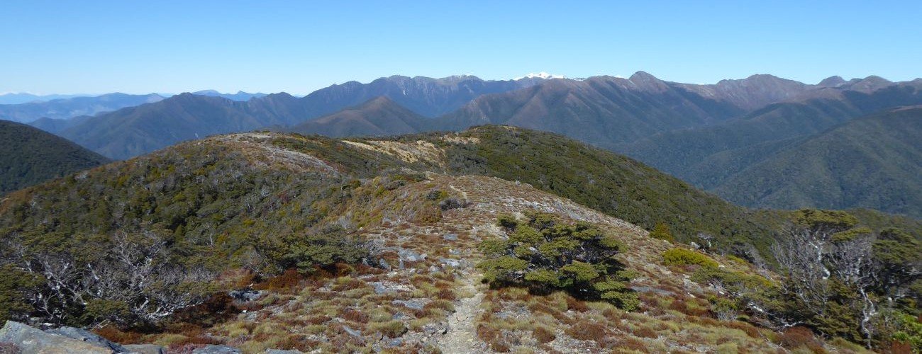
A private two-man bivvy is located a short distance south of the ridge, and offers a little more shelter for a lunch stop if a wind is blowing. Otherwise continue straight along the ridge, following the well-worn track and cairns. The summit ridge is fortified with rocky outcrops, some of which you will have to climb over. The true summit is not the highest point on the ridge; the track reaches approximately 1270 m before dropping slightly to the trig at 1249 m. This marks the end of the track. The views from the trig are breathtaking; most of Golden Bay is clearly visible, and Haupiri Range and Lead Hills stand out to the south. On clear mornings you may even be able to see Mt Taranaki.
Return the way you came. The steep sections you encountered on the way are up more difficult to descend than climb, so take your time lowering yourself down. Also be mindful that fallen dracophyllum fronds that litter the track are quite slippery underfoot.
Parapara Peak Track requires dry weather in the days prior; both Pariwhakaoho River and Copperstain Creek will be impassable following heavy or prolonged rain. The track reaches high elevation and above the treeline it is highly exposed. Make sure you prepare accordingly with proper outdoor clothing. If snow and ice are present, be very careful as you make your way along the narrow summit ridge. Take plenty of water with you as there are no water sources beyond Copperstain Creek. There are some sections of the track that are very steep, and require great care as you descend them.
See the Mountain Safety Council website for useful information on preparing for the outdoors.
The base of Parapara Peak was prospected for rare minerals 1960s. A rough road was bulldozed up Copperstain Creek to support the operations, and the original vegetation is yet to fully recover. Gerard Hindmarsh details this further in Kahurangi Calling, along with the extraordinary feats of stockmen in the first half of the 1900s whom drove sheep up what is now the modern day track, and further into the alpine basins like Boulder Lake for grazing.


Parapara Peak (1249 m) rises steeply above the coastal plain of Golden Bay, between Takaka and Collingwood. Located in Kahurangi National Park, a return trip to the summit is a physically-demanding full-day walk, requiring a high level of fitness. For your efforts you will be rewarded with a diverse range of stunning native bush, as well as what are probably the best views of Golden Bay.
| Details | |
| Length | 18.4 km return |
| Time Required | 8-9 hr return for most, though fit parties may be as quick as 6 hr return |
| Trail Type | Tramping track |
| Physical Difficulty | Hard |
| Uses | Walking and trail running |
| Direction | Return (up and down) |
| Start Elevation | 75 m |
| Max Elevation | 1270 m |
| Dog Access | Dogs are prohibited in Kahurangi National Park |
This elevation profile should be considered approximate. Its accuracy is determined by the quality of data available.
1 hr 30 min from Nelson | 10 min from Takaka
Parapara Peak Track begins at the end of Ward-Holmes Road in Puramāhoi, which is a left hand turn off of State Highway 60, 12 km northwest of Takaka. There is a small grassed car park at the road end and a structure with a DOC intentions book.
The track enters Kahurangi National Park at the end of the paddock after the car park, before you enter the bush.
Immediately after the car park you will have to cross Pariwhakaoho River and follow the farm track towards the bush. The river will be impassable if running high. The track passes paddocks and then enters the bush, soon climbing the steep-sided gully of Copperstain Creek, literally in the creek bed. The bush in the gully has a primeval feel, with nikau, tree ferns and epiphyte-smothered beech and podocarps towering above.
The track climbs out of the creek gully and zig-zags up the side of a spur, gaining the crest of it and continuing more or less straight up. Openings in the bush allows good views across the coastal plain to the bay. You will reach a knob with a small clearing on top, where a DOC sign reads ‘Para para Track’ reassuring you that you are indeed on the correct track. This is approximately the halfway point (4.5 km) of the uphill leg, though a little further along the ridge you will face the steepest climb of the day, where the track heads directly up the ridge for several hundred metres, at an angle that feels like 45°. After this climb the track crosses an area of marble geology and the surrounding bush soon becomes entirely dracophyllum.
The forest makes way for low sub-alpine scrub at 1100 m elevation, at which point the amount of climbing you’ve done truly becomes apparent. It is a short distance to the crest of the summit ridge.
A private two-man bivvy is located a short distance south of the ridge, and offers a little more shelter for a lunch stop if a wind is blowing. Otherwise continue straight along the ridge, following the well-worn track and cairns. The summit ridge is fortified with rocky outcrops, some of which you will have to climb over. The true summit is not the highest point on the ridge; the track reaches approximately 1270 m before dropping slightly to the trig at 1249 m. This marks the end of the track. The views from the trig are breathtaking; most of Golden Bay is clearly visible, and Haupiri Range and Lead Hills stand out to the south. On clear mornings you may even be able to see Mt Taranaki.
Return the way you came. The steep sections you encountered on the way are up more difficult to descend than climb, so take your time lowering yourself down. Also be mindful that fallen dracophyllum fronds that litter the track are quite slippery underfoot.
Parapara Peak Track requires dry weather in the days prior; both Pariwhakaoho River and Copperstain Creek will be impassable following heavy or prolonged rain. The track reaches high elevation and above the treeline it is highly exposed. Make sure you prepare accordingly with proper outdoor clothing. If snow and ice are present, be very careful as you make your way along the narrow summit ridge. Take plenty of water with you as there are no water sources beyond Copperstain Creek. There are some sections of the track that are very steep, and require great care as you descend them.
See the Mountain Safety Council website for useful information on preparing for the outdoors.
Parapara Peak Track does not connect to any other official tracks. The route connecting it with Pupu Hydro Walkway has not been maintained for nearly two decades.
Updated 29 January 2019