and Lake Peel
Balloon Hut is located at the end of Lake Peel Track, between Cobb Valley and Mt Arthur, in Kahurangi National Park. It’s a great destination for an overnight trip from Cobb Valley, and is also commonly used as a second night stay on three day trips from Flora car park to Cobb Valley. The climb to Balloon Hut from Cobb Valley will take you up and around the spectacular Lake Peel and Peel Range, before descending to the remarkable tussock expanse of the Tableland.
| Details | |
| Distances | 8.4 km Cobb Valley Rd to Balloon Hut via Lake Peel Track; 13.7 km Cobb Valley Rd to Balloon Hut via Cobb Ridge; 3.3 km Lake Peel to Balloon Hut; 4.1 km Balloon Hut to Salisbury Lodge |
| Time Required | 4 hr one way to Balloon Hut via Lake Peel Track; 4 hr return to Lake Peel via Lake Peel Track; 1 hr 30 min Balloon Hut to Salisbury Lodge |
| Trail Type | Tramping track/Poled route |
| Physical Difficulty | Moderate |
| Uses | Walking and trail running |
| Direction | Either |
| Start Elevation | 830 m (Cobb Valley) |
| Max Elevation | 1440 m (Peel Range) |
| Dog Access | Dogs are prohibited in Kahurangi National Park |
If any layers fail to load, try clearing your cache and refreshing the page.
2 hr from Nelson | 1 hr from Takaka
From Richmond, head west along State Highway 60. After you’ve driven over Takaka Hill, turn left at Upper Takaka onto Cobb Dam Road, and follow it up Cobb Valley and over the ridge to Cobb Reservoir. The road is very narrow and has steep drop-offs to Takaka River below, so you must drive with caution. The road is unsealed from the turbine house, and reaches 1100 m elevation at Cobb Ridge, meaning snow and ice can be present throughout the year.
Follow the road the whole way along the reservoir and park in the small grassed car park on the left (signpost reads Lake Peel Track).
From the car park, Lake Peel Track heads through grass and scrub to Myttons Hut (10 min). Myttons Hut is classed as a basic hut and is in a slightly awkward location, being so close to the road, though it is certainly a more homely alternative to nearby Trilobite Hut.
| Myttons Hut | |
| Hut Type | Basic Hut |
| Capacity | 4 bunks |
| Bookings | Not required; first in, first served |
| Fee | No fee |
| Altitude | 910 m |
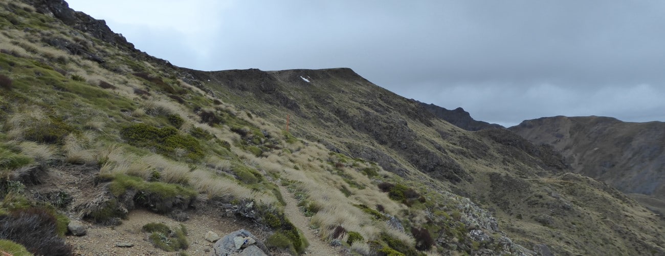
From Myttons Hut the track climbs up the side of the valley through a series of wide zig-zags. The treeline is reached after 2.3 km, where you emerge into tussock and alpine shrubs. The track from here is a poled route all the way to Balloon Hut, so pay attention to the poles when snow hides the track. It’s a steep scramble from the treeline to the crest of the range.
At the crest of the range you will reach a tee junction with Cobb Ridge Track, which heads left (north). Continue straight, as the track dips into Deep Creek valley and sidles the steep valley side, passing beneath massive bluffs and across rock slide deposits. The cirque that holds Lake Peel can be seen ahead, though the true summit of Mt Peel is obscured by the ridge that leads to it. The track crosses the outlet of Lake Peel (Deep Creek) and then reaches the lake itself. If you’re brave the lake is a good place for a quick dip in summer.
A side trip can be made to the summit of Mt Peel (1654 m). There is no official track, though the most commonly-used route is easy in clear conditions. The route begins approx. 1 km south of Lake Peel (towards Balloon Hut), where there is a boulder with a DOC sign attached to it. Climb west onto the crest of the ridge that bounds the western edge of the Lake Peel cirque. Head north along the broad, largely featureless ridge until you reach a small cairn marking the summit at the obvious high point. Return the way you came. Allow an extra 1 hr 30 min for a summit trip.
The track climbs out of the southern side of the valley and then descends along the broad Peel Range through snow tussock all the way to Balloon Hut (3.3 km from Lake Peel). Along this section you’ll enjoy spectacular views straight ahead to Mt Arthur and the Twins on fine days.
Balloon Hut is nestled against the treeline at 1260 m elevation. There are no grand views from the hut itself, though the beech and tussock outlook is very nice. There are plenty of weka around and you will hear morepork at night. The current edition of the hut has been in place since a refurbishment in 1995. A framed picture on the wall shows the history of the hut, right back to when it was first constructed in 1909.
| Balloon Hut | |
| Hut Type | Serviced Hut |
| Capacity | 14 bunks |
| Bookings | Not required; first in, first served |
| Fee | 1 Serviced Hut Ticket |
| Altitude | 1260 m |
Salisbury Lodge is a short distance from Balloon Hut (4.1 km, 1 hr 30 min). From Balloon Hut, the track continues east through a corridor of tussock just east of Balloon Hill. You’ll drop down into a karst amphitheater known as ‘The Clearing’ near the head of Cundy Creek, then climb back onto another tussock expanse, where the track junction to Leslie-Karamea Track is located (Karamea Bend Hut is 4 hr distant of here). The track continues through the tussock and passes the turnoff to Starvation Ridge Track. The remainder of the gentle decent to Salisbury Lodge passes through stunted mountain beech and dracophyllum.
Lake Peel Track traverses an alpine environment, and Peel Range and the Tableland are particularly exposed. Make sure you prepare accordingly, even in summer, as freezing alpine conditions can occur at any time of year. Do not rely on weather forecasts for Motueka or Takaka as the alpine weather is likely to be drastically different. Be mindful of the karst landscape east of Balloon Hut, where there are hidden caves and sinkholes. Be sure to record your intentions at Trilobite Hut, as well as huts along the way.
See the Mountain Safety Council website for useful information on preparing for the outdoors.


Balloon Hut is located at the end of Lake Peel Track, between Cobb Valley and Mt Arthur, in Kahurangi National Park. It’s a great destination for an overnight trip from Cobb Valley, and is also commonly used as a second night stay on three day trips from Flora car park to Cobb Valley. The climb to Balloon Hut from Cobb Valley will take you up and around the spectacular Lake Peel and Peel Range, before descending to the remarkable tussock expanse of the Tableland.
| Details | |
| Distances | 8.4 km Cobb Valley Rd to Balloon Hut via Lake Peel Track; 13.7 km Cobb Valley Rd to Balloon Hut via Cobb Ridge; 3.3 km Lake Peel to Balloon Hut; 4.1 km Balloon Hut to Salisbury Lodge |
| Time Required | 4 hr one way to Balloon Hut via Lake Peel Track; 4 hr return to Lake Peel via Lake Peel Track; 1 hr 30 min Balloon Hut to Salisbury Lodge |
| Trail Type | Tramping track/Poled route |
| Physical Difficulty | Moderate |
| Uses | Walking and trail running |
| Direction | Either |
| Start Elevation | 830 m (Cobb Valley) |
| Max Elevation | 1440 m (Peel Range) |
| Dog Access | Dogs are prohibited in Kahurangi National Park |
2 hr from Nelson | 1 hr from Takaka
From Richmond, head west along State Highway 60. After you’ve driven over Takaka Hill, turn left at Upper Takaka onto Cobb Dam Road, and follow it up Cobb Valley and over the ridge to Cobb Reservoir. The road is very narrow and has steep drop-offs to Takaka River below, so you must drive with caution. The road is unsealed from the turbine house, and reaches 1100 m elevation at Cobb Ridge, meaning snow and ice can be present throughout the year.
Follow the road the whole way along the reservoir and park in the small grassed car park on the left (signpost reads Lake Peel Track).
From the car park, Lake Peel Track heads through grass and scrub to Myttons Hut (10 min). Myttons Hut is classed as a basic hut and is in a slightly awkward location, being so close to the road, though it is certainly a more homely alternative to nearby Trilobite Hut.
| Myttons Hut | |
| Hut Type | Basic Hut |
| Capacity | 4 bunks |
| Bookings | Not required; first in, first served |
| Fee | No fee |
| Altitude | 910 m |
From Myttons Hut the track climbs up the side of the valley through a series of wide zig-zags. The treeline is reached after 2.3 km, where you emerge into tussock and alpine shrubs. The track from here is a poled route all the way to Balloon Hut, so pay attention to the poles when snow hides the track. It’s a steep scramble from the treeline to the crest of the range.
At the crest of the range you will reach a tee junction with Cobb Ridge Track, which heads left (north). Continue straight, as the track dips into Deep Creek valley and sidles the steep valley side, passing beneath massive bluffs and across rock slide deposits. The cirque that holds Lake Peel can be seen ahead, though the true summit of Mt Peel is obscured by the ridge that leads to it. The track crosses the outlet of Lake Peel (Deep Creek) and then reaches the lake itself. If you’re brave the lake is a good place for a quick dip in summer.
A side trip can be made to the summit of Mt Peel (1654 m). There is no official track, though the most commonly-used route is easy in clear conditions. The route begins approx. 1 km south of Lake Peel (towards Balloon Hut), where there is a boulder with a DOC sign attached to it. Climb west onto the crest of the ridge that bounds the western edge of the Lake Peel cirque. Head north along the broad, largely featureless ridge until you reach a small cairn marking the summit at the obvious high point. Return the way you came. Allow an extra 1 hr 30 min for a summit trip.
The track climbs out of the southern side of the valley and then descends along the broad Peel Range through snow tussock all the way to Balloon Hut (3.3 km from Lake Peel). Along this section you’ll enjoy spectacular views straight ahead to Mt Arthur and the Twins on fine days.
Balloon Hut is nestled against the treeline at 1260 m elevation. There are no grand views from the hut itself, though the beech and tussock outlook is very nice. There are plenty of weka around and you will hear morepork at night. The current edition of the hut has been in place since a refurbishment in 1995. A framed picture on the wall shows the history of the hut, right back to when it was first constructed in 1909.
| Balloon Hut | |
| Hut Type | Serviced Hut |
| Capacity | 14 bunks |
| Bookings | Not required; first in, first served |
| Fee | 1 Serviced Hut Ticket |
| Altitude | 1260 m |
Salisbury Lodge is a short distance from Balloon Hut (4.1 km, 1 hr 30 min). From Balloon Hut, the track continues east through a corridor of tussock just east of Balloon Hill. You’ll drop down into a karst amphitheater known as ‘The Clearing’ near the head of Cundy Creek, then climb back onto another tussock expanse, where the track junction to Leslie-Karamea Track is located (Karamea Bend Hut is 4 hr distant of here). The track continues through the tussock and passes the turnoff to Starvation Ridge Track. The remainder of the gentle decent to Salisbury Lodge passes through stunted mountain beech and dracophyllum.
Lake Peel Track traverses an alpine environment, and Peel Range and the Tableland are particularly exposed. Make sure you prepare accordingly, even in summer, as freezing alpine conditions can occur at any time of year. Do not rely on weather forecasts for Motueka or Takaka as the alpine weather is likely to be drastically different. Be mindful of the karst landscape east of Balloon Hut, where there are hidden caves and sinkholes. Be sure to record your intentions at Trilobite Hut, as well as huts along the way.
See the Mountain Safety Council website for useful information on preparing for the outdoors.
Updated 23 January 2019