Hooker Valley Track is the most popular short walk in Aoraki / Mount Cook National Park. Beginning a short distance from Mt Cook Village, the easy walk provides breath-taking views of the lofty peaks of the Southern Alps / Kā Tiritiri o te Moana, including Aoraki / Mt Cook.
| Details | |
| Length | 10.2 km return |
| Time Required | 3 hr return |
| Trail Type | Walking track |
| Physical Difficulty | Easy |
| Uses | Walking and trail running |
| Start Elevation | 780 m |
| Max Elevation | 885 m |
| Dog Access | Dogs are prohibited |
If any layers fail to load, try clearing your cache and refreshing the page.
Kea Point Track
Walking and trail running
2 min from Mount Cook Village
Hooker Valley Track begins at the car park at White Horse Hill Campground, located a two minute drive from Mt Cook Village. Here there are toilets and a kiosk with information on the track conditions and any warnings in place.
From the car park, the wide, well-graded track passes the Alpine Memorial and Freda’s Rock, then drops into the gully carved by the Hooker River, which drains the proglacial lake that has formed as the Mueller Glacier has retreated. The track crosses the river via a suspension bridge, then sidles the lake atop the lateral moraine of the Mueller Glacier, offering good views of it as well as the dramatic glacier-laden Mt Sefton (3157 m) towering more than 2.3 km vertically above you, immediately ahead.
The second suspension bridge crosses the deep ravine cut by the river that drains Hooker Lake, after which the track heads north, climbing at a gentle gradient up the hummocky floor of the Hooker Valley through tussock and sub-alpine scrub. The third suspension bridge crosses the river again, then the track climbs past car-sized boulders over the most recent moraine of the Hooker Glacier, to the viewpoint above Hooker Lake.
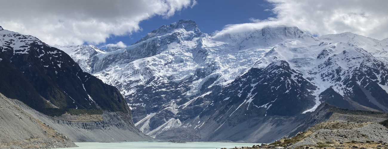
The track ends at the lake, which has formed as the Hooker Glacier has retreated. Here, on clear days, you will enjoy stunning views of Aoraki/Mt Cook (3724 m), located 11 km away, straight ahead up the valley. The lake is an opaque turquoise-grey colour due to the glacially-eroded sediment that is suspended in the water. The lake holds icebergs that have calved off the face of the Hooker Glacier, and in winter it can freeze over completely. Hooker Valley and Hooker Glacier were named by Sir Julius von Haast (Canterbury provincial geologist in the 1860s) after William Jackson Hooker, an English Botanist.
Return the way you came.


Hooker Valley Track is the most popular short walk in Aoraki / Mount Cook National Park. Beginning a short distance from Mt Cook Village, the easy walk provides breath-taking views of the lofty peaks of the Southern Alps / Kā Tiritiri o te Moana, including Aoraki / Mt Cook.
| Details | |
| Length | 10.2 km return |
| Time Required | 3 hr return |
| Trail Type | Walking track |
| Physical Difficulty | Easy |
| Uses | Walking and trail running |
| Start Elevation | 780 m |
| Max Elevation | 885 m |
| Dog Access | Dogs are prohibited |
2 min from Mount Cook Village
Hooker Valley Track begins at the car park at White Horse Hill Campground, located a two minute drive from Mt Cook Village. Here there are toilets and a kiosk with information on the track conditions and any warnings in place.
From the car park, the wide, well-graded track passes the Alpine Memorial and Freda’s Rock, then drops into the gully carved by the Hooker River, which drains the proglacial lake that has formed as the Mueller Glacier has retreated. The track crosses the river via a suspension bridge, then sidles the lake atop the lateral moraine of the Mueller Glacier, offering good views of it as well as the dramatic glacier-laden Mt Sefton (3157 m) towering more than 2.3 km vertically above you, immediately ahead.
The second suspension bridge crosses the deep ravine cut by the river that drains Hooker Lake, after which the track heads north, climbing at a gentle gradient up the hummocky floor of the Hooker Valley through tussock and sub-alpine scrub. The third suspension bridge crosses the river again, then the track climbs past car-sized boulders over the most recent moraine of the Hooker Glacier, to the viewpoint above Hooker Lake.
The track ends at the lake, which has formed as the Hooker Glacier has retreated. Here, on clear days, you will enjoy stunning views of Aoraki/Mt Cook (3724 m), located 11 km away, straight ahead up the valley. The lake is an opaque turquoise-grey colour due to the glacially-eroded sediment that is suspended in the water. The lake holds icebergs that have calved off the face of the Hooker Glacier, and in winter it can freeze over completely. Hooker Valley and Hooker Glacier were named by Sir Julius von Haast (Canterbury provincial geologist in the 1860s) after William Jackson Hooker, an English Botanist.
Return the way you came.
Kea Point Track
Walking and trail running
Updated 16 October 2022