Te Waikoropupū Springs in Golden Bay are the largest freshwater springs in New Zealand and the largest cold water springs in the southern hemisphere. They are renowned for their amazing clarity and are considered a taonga (treasure) by Māori. An easy loop walkway showcases the springs and the native bush that surrounds them.
| Details | |
| Length | 1 km |
| Time Required | Allow 40 min |
| Trail Type | Walking track |
| Physical Difficulty | Easy |
| Uses | Walking |
| Direction | Either |
| Dog Access | Dogs are prohibited |
If any layers fail to load, try clearing your cache and refreshing the page.
Te Waikoropupū Springs Walkway does not connect to any other tracks.
10 min from Takaka
From Takaka, head north along SH60 to the bridge over Takaka River. Immediately after the bridge you will see the signposted turnoff to the springs, along Pupu Valley Rd. A short distance along the road turn left onto Pupu Springs Rd. The walkway has a large car park with toilets.
The land surrounding the springs is protected in Te Waikoropupū Springs Scenic Reserve.
The walkway starts and finishes at the car park, where a sheltered area with Māori carvings has information panels that provide interesting details on the history, hydrology and ecology of the springs. The walkway can be walked in either direction. Though it is only 1 km in length, allow a little more time to admire the springs.
The gravel walkway is wide and smooth. A few hundred metres from the car park a boardwalk crosses a shallow area of water flowing from Fish Creek Springs and then a bridge crosses the swift-flowing Fish Creek. Surrounding the walkway are impressive rimu, kahikatea and a particularly large mataī.
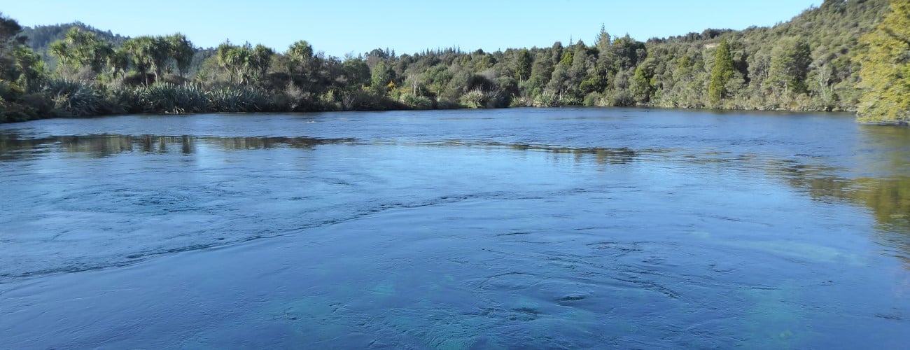
The walkway reaches a viewing platform that overlooks Main Spring. The rippling surface of the water masks its true clarity, though the aqua blue sands and colourful aquatic vegetation can be seen at the bottom of the springs’ basin, which has a deceptive depth of nearly 7 m. Dancing Sands Spring, separated from Main Spring by a small island, is a short distance further and has its own, smaller viewing platform.
The walkway heads back alongside Fish Creek, where a bridge crosses back to the start of the walkway next to the car park.
The springs are considered wāhi tapu (sacred) by Māori. Their waters were traditionally used for ceremonies and healing processes, and a taniwha named Huriawa was said to guard them. To preserve their clarity, no contact is allowed to be made with the water that flows from the springs. Be respectful of this when you visit.
Though collectively known as Te Waikoropupū Springs (and locally shortened to ‘Pupu’) there are actually three distinct springs; Main Spring, Dancing Sands Spring and Fish Creek Springs (a group of springs). Together they discharge water at a rate of over 13,000 L/s. Their water is exceptionally clear, with measurements in 2018 recording an underwater visual clarity distance of nearly 81 m. This makes the springs’ water, generally speaking, just as clear as Blue Lake in Nelson Lakes National Park (thought to be New Zealand’s clearest), which has an underwater visual clarity distance of 70-80 m. For context, the theoretical maximum optical clarity of pure water is 83 m.
The springs are fed by the Arthur Marble Aquifer, which underlies the floor of Takaka Valley and comprises a layer of marble up to a kilometre in thickness. Hydrogeological research into the aquifer has shown that there two flow separate systems; a shallow system and a deep system. A conceptual model proposes the deep system, fed solely by drainage from karst landscapes in the upper catchment, provides 74% of Main Springs’s flow; Takaka River and rainfall directly onto the valley floor contribute 18% and 8% respectively. By comparison, half of Fish Creek Springs’ flow originates from Takaka River, with the karst uplands and direct rainfall each contributing 25%. On average, from the time it entered the ground, water is underground for 8 years before it emerges from Main Spring (for Fish Creek Springs it is just over 3 years).
The springs also have a saltwater influence, even though the coast is 4 km distant. On average, the saltwater component of Main Spring is 0.5%, while for Fish Creek Springs it is 0.1%. However, this varies with flow; during low flow conditions the saltwater component at Main Spring is 0.2%, but following heavy rainfall, increased aquifer pressure in the deep system induces the venturi effect, drawing salt upwards from intruded seawater (which underlies the Arthur Marble Aquifer). This results in a five-fold increase in Main Spring’s saltwater component, to 0.65%.


Te Waikoropupū Springs in Golden Bay are the largest freshwater springs in New Zealand and the largest cold water springs in the southern hemisphere. They are renowned for their amazing clarity and are considered a taonga (treasure) by Māori. An easy loop walkway showcases the springs and the native bush that surrounds them.
| Details | |
| Length | 1 km |
| Time Required | Allow 40 min |
| Trail Type | Walking track |
| Physical Difficulty | Easy |
| Uses | Walking |
| Direction | Either |
| Dog Access | Dogs are prohibited |
10 min from Takaka
From Takaka, head north along SH60 to the bridge over Takaka River. Immediately after the bridge you will see the signposted turnoff to the springs, along Pupu Valley Rd. A short distance along the road turn left onto Pupu Springs Rd. The walkway has a large car park with toilets.
The land surrounding the springs is protected in Te Waikoropupū Springs Scenic Reserve.
The walkway starts and finishes at the car park, where a sheltered area with Māori carvings has information panels that provide interesting details on the history, hydrology and ecology of the springs. The walkway can be walked in either direction. Though it is only 1 km in length, allow a little more time to admire the springs.
The gravel walkway is wide and smooth. A few hundred metres from the car park a boardwalk crosses a shallow area of water flowing from Fish Creek Springs and then a bridge crosses the swift-flowing Fish Creek. Surrounding the walkway are impressive rimu, kahikatea and a particularly large mataī.
The walkway reaches a viewing platform that overlooks Main Spring. The rippling surface of the water masks its true clarity, though the aqua blue sands and colourful aquatic vegetation can be seen at the bottom of the springs’ basin, which has a deceptive depth of nearly 7 m. Dancing Sands Spring, separated from Main Spring by a small island, is a short distance further and has its own, smaller viewing platform.
The walkway heads back alongside Fish Creek, where a bridge crosses back to the start of the walkway next to the car park.
The springs are considered wāhi tapu (sacred) by Māori. Their waters were traditionally used for ceremonies and healing processes, and a taniwha named Huriawa was said to guard them. To preserve their clarity, no contact is allowed to be made with the water that flows from the springs. Be respectful of this when you visit.
Though collectively known as Te Waikoropupū Springs (and locally shortened to ‘Pupu’) there are actually three distinct springs; Main Spring, Dancing Sands Spring and Fish Creek Springs (a group of springs). Together they discharge water at a rate of over 13,000 L/s. Their water is exceptionally clear, with measurements in 2018 recording an underwater visual clarity distance of nearly 81 m. This makes the springs’ water, generally speaking, just as clear as Blue Lake in Nelson Lakes National Park (thought to be New Zealand’s clearest), which has an underwater visual clarity distance of 70-80 m. For context, the theoretical maximum optical clarity of pure water is 83 m.
The springs are fed by the Arthur Marble Aquifer, which underlies the floor of Takaka Valley and comprises a layer of marble up to a kilometre in thickness. Hydrogeological research into the aquifer has shown that there two flow separate systems; a shallow system and a deep system. A conceptual model proposes the deep system, fed solely by drainage from karst landscapes in the upper catchment, provides 74% of Main Springs’s flow; Takaka River and rainfall directly onto the valley floor contribute 18% and 8% respectively. By comparison, half of Fish Creek Springs’ flow originates from Takaka River, with the karst uplands and direct rainfall each contributing 25%. On average, from the time it entered the ground, water is underground for 8 years before it emerges from Main Spring (for Fish Creek Springs it is just over 3 years).
The springs also have a saltwater influence, even though the coast is 4 km distant. On average, the saltwater component of Main Spring is 0.5%, while for Fish Creek Springs it is 0.1%. However, this varies with flow; during low flow conditions the saltwater component at Main Spring is 0.2%, but following heavy rainfall, increased aquifer pressure in the deep system induces the venturi effect, drawing salt upwards from intruded seawater (which underlies the Arthur Marble Aquifer). This results in a five-fold increase in Main Spring’s saltwater component, to 0.65%.
Te Waikoropupū Springs Walkway does not connect to any other tracks.
Updated 16 August 2020