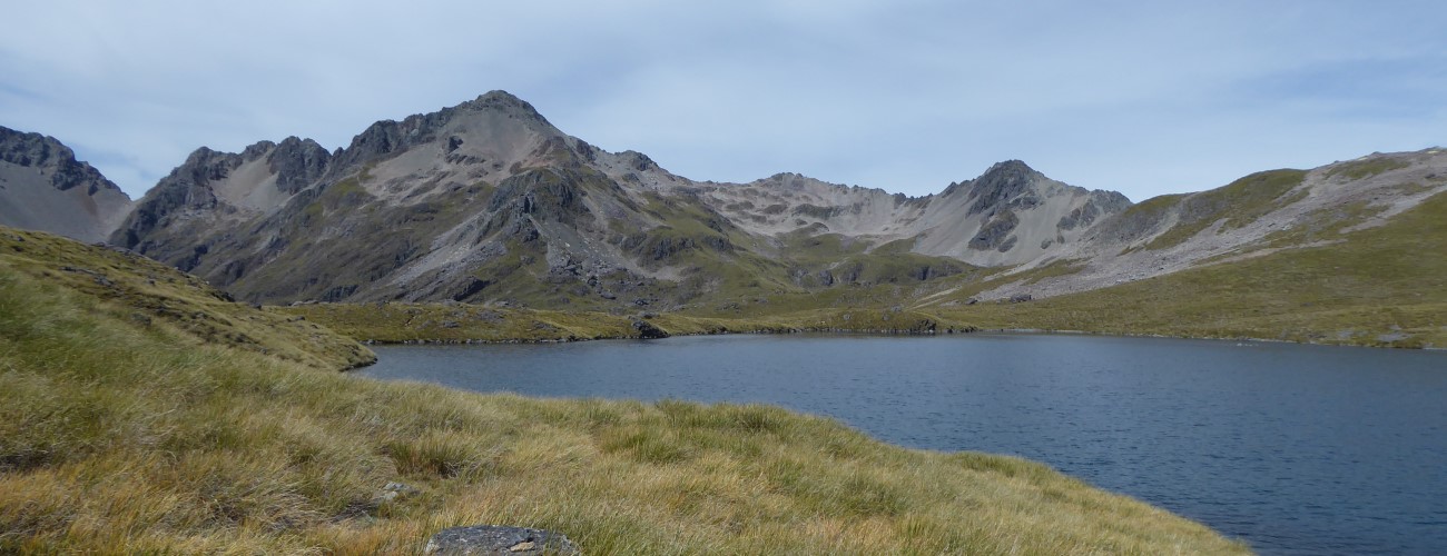
Angelus Hut is located in a spectacular setting next to Rotomaninitua / Lake Angelus at 1650 m elevation, on the Travers Range in Nelson Lakes National Park. The hut is popular for overnight trips and multi-day traverses through the park, and can even be visited in a single day if weather, daylight and fitness allow it. It is commonly accessed via Robert Ridge Route, though there are four other routes leading directly to it, allowing for circuits to suit different abilities and weather conditions.
| Details | |
| Distances (to Angelus Hut) | 11.8 km from Mt Robert car park (via Robert Ridge Route); 5 km from Speargrass Hut (via Speargrass Creek Route); 7.2 km from Sabine Hut (via Mt Cedric Route); 9.7 km from Coldwater Hut (via Cascade Track); 6 km from Hopeless Hut (via Sunset Saddle) |
| Time Required | 5-7 hr from Mt Robert car park (via Robert Ridge Route); 3-4 hr from Speargrass Hut (via Speargrass Creek Route); 5-6 hr from Sabine Hut (via Mt Cedric Route); 5-6 hr from Coldwater Hut (via Cascade Track); 3-4 hr from Hopeless Hut (via Sunset Saddle) |
| Trail Type | Tramping track/Poled route |
| Physical Difficulty | Hard |
| Uses | Walking and trail running |
If any layers fail to load, try clearing your cache and refreshing the page.
Mt Robert Circuit
Walking and trail running
Hopeless Hut (via Sunset Saddle)
Walking
Sabine Hut (via Mt Cedric Route)
Walking and trail running
Speargrass Hut (via Speargrass Creek Route)
Walking and trail running
Travers Valley (Cascade Track)
Walking and trail running
Angelus Hut can only be accessed via alpine routes that each require a high level of preparedness.
Robert Ridge Route is extremely exposed; between the tree line at Pinchgut Track and Angelus Hut you will have to traverse nearly 10 km of open tops, with no easy escape routes. Though it is relatively straight-forward in good conditions, it quickly gets difficult and dangerous when the temperature drops and the wind picks up. Multiple fatalities have occurred here from people being underprepared or caught out by cold weather. Be sure to check the Nelson Lakes alpine weather forecast before you go (the DOC visitor centre at St Arnaud provides daily weather outlook updates). You must carry adequate alpine clothing, even in summer. Sections of the route are extremely hazardous when snow and ice is present.
Though the cold is the obvious hazard, warm and sunny conditions also require preparation. There are no water sources immediate to the route between Relax Shelter and Angelus Hut, so make sure you carry plenty of your own. As Robert Ridge Route is entirely above the tree line, there is no shade whatsoever, so make sure you apply sunscreen appropriately.
See the Mountain Safety Council website, as well as their video below, for useful information on preparing for an Angelus Hut trip.
1 hr 10 min from Nelson | 1 hr 20 min from Blenheim
The most straightforward way to Angelus Hut is via Robert Ridge, which is accessed from Mt Robert car park, at the end of Mt Robert Road. The turnoff to Mt Robert Road a 2 minute drive west of St Arnaud along State Highway 63. Mt Robert Road passes West Bay where there is parking and a campsite, crosses the source of the Buller River and reaches Mt Robert car park at 900 m elevation. There is a small shelter, toilets and a trail info panel at the car park. The car park is large but fills up on busy weekends. The road can be icy in winter, so take care when driving.
Nelson Lakes DOC Visitor Centre is located on View Road, St Arnaud. This is a good place to read up on the ecology, geology and history of St Arnaud and Nelson Lakes National Park, as well as check the latest alpine weather forecasts and speak to DOC staff about any warnings in place.
Beginning at Mt Robert car park, Pinchgut Track zig-zags up the bare northern aspect of Mt Robert. The climb is unrelenting, though the gradient is never too steep and there are ample opportunities to stop and admire the view of the lake below. The lack of shade means this can be a warm climb on sunny days. The upper portion of the track zig-zags through beech forest, which becomes more stunted as you approach the tree line at 1360 m elevation. The crest of the ridge is just above the tree line, where the gradient flattens out and the well-worn track (now a poled route) follows the broad ridge south through snow tussock to Relax Shelter, which is a good place to put on warm layers if there’s a cold wind blowing. You will reach a junction where Paddy’s Track forks left (east) and Robert Ridge Route continues straight (south) along the ridge.
Onward from the junction, Robert Ridge Route climbs gradually along the ridge and skirts the upper edge of 2nd Basin, where you’ll see the buildings of the old Mt Robert Skifield. At the southern end of 2nd Basin the track crosses over the summit of Flagtop (1690 m), and then heads along the edge of 3rd Basin. At the southern end of 3rd Basin the route traverses larger boulders, which will slow progress. It then crosses over into a basin on the western side of the range, as it sidles beneath the craggy knob of Julius Summit. This is the first tricky section of the route, where you’ll have to carefully negotiate your way across the bouldery slope.
Once on the other side, you’ll traverse above the top of the tarn-dotted 4th Basin. The ridge is quite narrow here, and you’ll need to be careful as you make your way along the loose rocks. Along here you’ll reach the highest point of Robert Ridge Route (1800 m). The route again sidles the western side of the ridge, then drops into a saddle at the head of Speargrass Valley, where Speargrass Creek Route begins on the right (Speargrass Hut is 2 hr 30 min from here). After a short climb onto the ridge on the opposite side of the saddle, you’ll get your first view of the glacial cirque that holds Lake Angelus, with Angelus Hut positioned alongside. The track winds down the rocky slope for 10 min to the hut.
| Angelus Hut | |
| Hut Type | Serviced Hut |
| Capacity | 28 |
| Bookings | Required |
| Fee | Varies by season |
| Altitude | 1650 m |
You can explore the surrounding landscape around Angelus Hut. A good side trip in summer is Maniniaro / Angelus Peak (2075 m), the summit of which provides breath-taking views of the craggy ranges of Nelson Lakes National Park. From the hut, follow the route to Sunset Saddle, which drops around the outlet of Hinapouri Tarn then climbs into the basin above it. Instead of heading toward the saddle, follow the cairns to the left and climb the steep slope towards the obvious peak. The last few hundred metres to the summit climb steeply over loose scree and you will need to take care not to dislodge rocks onto others below you. Expect a return trip to Angelus Peak to take 3-4 hr (from Angelus Hut).
An overnight trip to Angelus Hut commonly involves using Speargrass Creek Route on the return leg back to Mt Robert car park. From Angelus Hut, head northward back up the ridge above the basin to the saddle at the head of Speargrass Valley. Turn left here and follow Speargrass Creek Route as it descends steeply into the valley through snow tussock. The route cuts across the toe of a massive scree slope on the western side of Robert Ridge, that comes right down to the creek. Don’t linger along here as loose rocks are precariously positioned on the slope above, and there is danger of rockfall. Towards the bottom of the valley the gradient lessens and the route enters low sub-alpine scrub and crosses the creek multiple times. The route passes through beech forest for the final kilometre to Speargrass Hut.
Speargrass Creek Route is a good alternative when poor weather makes Robert Ridge too dangerous. Note that the route may be impassable when Speargrass Creek is running high.
Mt Cedric Route climbs the western ridge above Angelus Basin and follows a spur to Mt Cedric (1532 m) the geographic position of which is a nondescript location a few hundred metres above the tree line. Before reaching the tree line you’ll enjoy magnificent views along the length of Lake Rotoroa and up Sabine Valley. The track steeply descends the crest of the spur through beech forest directly to Sabine Hut.
Cascade Track begins a few metres from the hut. The descent into Hukere Valley begins gently, before quickly steeping as the track drops down the bluffs of the upper valley through snow tussock and sections of loose scree. The track drops down alongside the cascading waterfall that empties Lake Angelus and Hinapouri Tarn to form Hukere Stream, then crosses the base of it. On the valley floor there is a grassy clearing before the track enters beech forest. The track descends the valley, never deviating too far from Hukere Stream, which tumbles (or ‘cascades’) down the valley. At one point the stream takes an underground path through a scree slope that has cut into its course. Once on the floor of Travers Valley, the track connects with Travers Valley Track, where you can turn left to get to Coldwater Hut (4 km away) or right to John Tait Hut (10.5 km away.
Note that the steep upper section of Cascade Track can be extremely hazardous when snow and ice is present. The track may also be impassable when Hukere Stream is running high.


Angelus Hut is located in a spectacular setting next to Rotomaninitua / Lake Angelus at 1650 m elevation, on the Travers Range in Nelson Lakes National Park. The hut is popular for overnight trips and multi-day traverses through the park, and can even be visited in a single day if weather, daylight and fitness allow it. It is commonly-accessed via Robert Ridge Route, though there are four other routes leading directly to it, allowing for circuits to suit different abilities and weather conditions.
| Details | |
| Distances (to Angelus Hut) | 11.8 km from Mt Robert car park (via Robert Ridge Route); 5 km from Speargrass Hut (via Speargrass Creek Route); 7.2 km from Sabine Hut (via Mt Cedric Route); 9.7 km from Coldwater Hut (via Cascade Track); 6 km from Hopeless Hut (via Sunset Saddle) |
| Time Required | 5-7 hr from Mt Robert car park (via Robert Ridge Route); 3-4 hr from Speargrass Hut (via Speargrass Creek Route); 5-6 hr from Sabine Hut (via Mt Cedric Route); 5-6 hr from Coldwater Hut (via Cascade Track); 3-4 hr from Hopeless Hut (via Sunset Saddle) |
| Trail Type | Tramping track/Poled route |
| Physical Difficulty | Hard |
| Uses | Walking and trail running |
If any layers fail to load, try clearing your cache and refreshing the page.
1 hr 10 min from Nelson | 1 hr 20 min from Blenheim
The most straightforward way to Angelus Hut is via Robert Ridge, which is accessed from Mt Robert car park, at the end of Mt Robert Road. The turnoff to Mt Robert Road a 2 minute drive west of St Arnaud along State Highway 63. Mt Robert Road passes West Bay where there is parking and a campsite, crosses the source of the Buller River and reaches Mt Robert car park at 900 m elevation. There is a small shelter, toilets and a trail info panel at the car park. The car park is large but fills up on busy weekends. The road can be icy in winter, so take care when driving.
Nelson Lakes DOC Visitor Centre is located on View Road, St Arnaud. This is a good place to read up on the ecology, geology and history of St Arnaud and Nelson Lakes National Park, as well as check the latest alpine weather forecasts and speak to DOC staff about any warnings in place.
Beginning at Mt Robert car park, Pinchgut Track zig-zags up the bare northern aspect of Mt Robert. The climb is unrelenting, though the gradient is never too steep and there are ample opportunities to stop and admire the view of the lake below. The lack of shade means this can be a warm climb on sunny days. The upper portion of the track zig-zags through beech forest, which becomes more stunted as you approach the tree line at 1360 m elevation. The crest of the ridge is just above the tree line, where the gradient flattens out and the well-worn track (now a poled route) follows the broad ridge south through snow tussock to Relax Shelter, which is a good place to put on warm layers if there’s a cold wind blowing. You will reach a junction where Paddy’s Track forks left (east) and Robert Ridge Route continues straight (south) along the ridge.
Onward from the junction, Robert Ridge Route climbs gradually along the ridge and skirts the upper edge of 2nd Basin, where you’ll see the buildings of the old Mt Robert Skifield. At the southern end of 2nd Basin the track crosses over the summit of Flagtop (1690 m), and then heads along the edge of 3rd Basin. At the southern end of 3rd Basin the route traverses larger boulders, which will slow progress. It then crosses over into a basin on the western side of the range, as it sidles beneath the craggy knob of Julius Summit. This is the first tricky section of the route, where you’ll have to carefully negotiate your way across the bouldery slope.
Once on the other side, you’ll traverse above the top of the tarn-dotted 4th Basin. The ridge is quite narrow here, and you’ll need to be careful as you make your way along the loose rocks. Along here you’ll reach the highest point of Robert Ridge Route (1800 m). The route again sidles the western side of the ridge, then drops into a saddle at the head of Speargrass Valley, where Speargrass Creek Route begins on the right (Speargrass Hut is 2 hr 30 min from here). After a short climb onto the ridge on the opposite side of the saddle, you’ll get your first view of the glacial cirque that holds Lake Angelus, with Angelus Hut positioned alongside. The track winds down the rocky slope for 10 min to the hut.
| Angelus Hut | |
| Hut Type | Serviced Hut |
| Capacity | 28 bunks |
| Bookings | Required |
| Fee | Varies by season |
| Altitude | 1650 m |
You can explore the surrounding landscape around Angelus Hut. A good side trip in summer is Maniniaro / Angelus Peak (2075 m), the summit of which provides breath-taking views of the craggy ranges of Nelson Lakes National Park. From the hut, follow the route to Sunset Saddle, which drops around the outlet of Hinapouri Tarn then climbs into the basin above it. Instead of heading toward the saddle, follow the cairns to the left and climb the steep slope towards the obvious peak. The last few hundred metres to the summit climb steeply over loose scree and you will need to take care not to dislodge rocks onto others below you. Expect a return trip to Angelus Peak to take 3-4 hr (from Angelus Hut).
An overnight trip to Angelus Hut commonly involves using Speargrass Creek Route on the return leg back to Mt Robert car park. From Angelus Hut, head northward back up the ridge above the basin to the saddle at the head of Speargrass Valley. Turn left here and follow Speargrass Creek Route as it descends steeply into the valley through snow tussock. The route cuts across the toe of a massive scree slope on the western side of Robert Ridge, that comes right down to the creek. Don’t linger along here as loose rocks are precariously positioned on the slope above, and there is danger of rockfall. Towards the bottom of the valley the gradient lessens and the route enters low sub-alpine scrub and crosses the creek multiple times. The route passes through beech forest for the final kilometre to Speargrass Hut.
Speargrass Creek Route is a good alternative when poor weather makes Robert Ridge too dangerous. Note that the route may be impassable when Speargrass Creek is running high.
Mt Cedric Route climbs the western ridge above Angelus Basin and follows a spur to Mt Cedric (1532 m) the geographic position of which is a nondescript location a few hundred metres above the tree line. Before reaching the tree line you’ll enjoy magnificent views along the length of Lake Rotoroa and up Sabine Valley. The track steeply descends the crest of the spur through beech forest directly to Sabine Hut.
Cascade Track begins a few metres from the hut. The descent into Hukere Valley begins gently, before quickly steeping as the track drops down the bluffs of the upper valley through snow tussock and sections of loose scree. The track drops down alongside the cascading waterfall that empties Lake Angelus and Hinapouri Tarn to form Hukere Stream, then crosses the base of it. On the valley floor there is a grassy clearing before the track enters beech forest. The track descends the valley, never deviating too far from Hukere Stream, which tumbles (or ‘cascades’) down the valley. At one point the stream takes an underground path through a scree slope that has cut into its course. Once on the floor of Travers Valley, the track connects with Travers Valley Track, where you can turn left to get to Coldwater Hut (4 km away) or right to John Tait Hut (10.5 km away.
Note that the steep upper section of Cascade Track can be extremely hazardous when snow and ice is present. The track may also be impassable when Hukere Stream is running high.
Angelus Hut can only be accessed via alpine routes that each require a high level of preparedness.
Robert Ridge Route is extremely exposed; between the tree line at Pinchgut Track and Angelus Hut you will have to traverse nearly 10 km of open tops, with no easy escape routes. Though it is relatively straight-forward in good conditions, it quickly gets difficult and dangerous when the temperature drops and the wind picks up. Multiple fatalities have occurred here from people being underprepared or caught out by cold weather. Be sure to check the Nelson Lakes alpine weather forecast before you go (the DOC visitor centre at St Arnaud provides daily weather outlook updates). You must carry adequate alpine clothing, even in summer. Sections of the route are extremely hazardous when snow and ice is present.
Though the cold is the obvious hazard, warm and sunny conditions also require preparation. There are no water sources immediate to the route between Relax Shelter and Angelus Hut, so make sure you carry plenty of your own. As Robert Ridge Route is entirely above the tree line, there is no shade whatsoever, so make sure you apply sunscreen appropriately.
See the Mountain Safety Council website, as well as their video below, for useful information on preparing for an Angelus Hut trip.
Updated 10 January 2021