Gordon’s Knob (1592 m) is a peak on the Gordon Range, southwest of Nelson. The unmarked route to the summit is a challenging full-day return trip through tussock and scree. The easiest way to access Gordon’s Knob is via Inwood Lookout. Gordon’s Knob is named after William Gordon Bell, who purchased land in the Upper Motueka valley the 1852. Golden Downs Forest, which today occupies the land he once owned, is a corruption of the original name ‘Gordon Downs’. The settlement of Belgrove also stems from the Bell surname.
| Details | |
| Length | 11 km return from Inwood Lookout |
| Time Required | 5-6 hr return from Inwood Lookout |
| Trail Type | Tramping track/Unmaintained route |
| Physical Difficulty | Hard |
| Uses | Walking |
| Direction | Return (up and down) |
| Start Elevation | 1060 m |
| Max Elevation | 1685 m |
| Dog Access | Permit required for Mt Richmond Forest Park; see local DOC office |
If any layers fail to load, try clearing your cache and refreshing the page.
This elevation profile should be considered approximate. Its accuracy is determined by the quality of data available.
1 hr 15 min from Nelson
Gordon’s Knob is accessed from Inwood Lookout. Head south from Nelson along State Highway 6. Just past Belgrove turn left onto Wai-iti Valley Road (the main road to St Arnaud from Nelson). The turnoff to Inwood Lookout (Wai-iti Road) is approximately 11 km from Belgrove. Allow 45 min to reach the Wai-iti Road turnoff from Nelson. The forestry road to the lookout, Wai-iti Road, is steep and rough, so a 4WD vehicle is recommended. Follow the orange DOC triangle markers along the road as it heads beneath the power pylons and climbs the pine-forested range to the car park at Inwood Lookout.
You can reach Gordon’s Knob via Motueka Gorge, though this is best done as an overnight trip; stay at Hunters Hut and tackle Gordon’s Knob on the second day, exiting via Inwood Lookout.
Logging and high fire risk will close access.
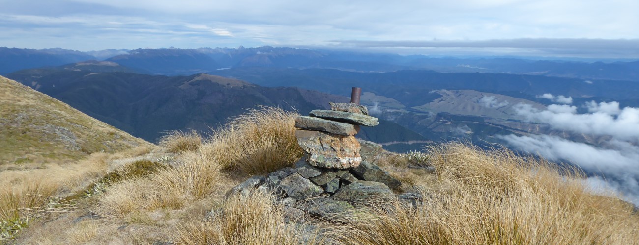
Begin on the track that continues south along the range from Inwood Lookout. The track alternates between open tussock and beech forest for the first kilometre, before opening up to low alpine scrub for the rest of the way along. The ridge is reasonably flat initially, then it starts steepening toward the main Gordon Range, gaining 300 m elevation in less than 900 m. There is one particularly scrambly bit where the track skirts beneath some craggy outcrops. Above this bit you will reach the turnoff to the unmaintained route up Gordon’s Knob; look out for a flat gravel area with a particularly large cairn. While the official poled route to Hunters Hut continues straight up the range (Hunters Hut is 2-3 hr away from this point), Gordon’s Knob Route deviates to the right from this cairn. There is no signage to indicate this, and the cairn is easily missed if you’re not paying attention.
From the turnoff the route continues as a well-worn path marked by cairns in the open sections and white markers through the patches of forest. It is reasonably easy to follow in clear conditions, though there a couple of sections you’ll need to keep an eye out for the next cairn, particularly on the return leg. The route sidles across some loose scree slopes and undulates across a saddle east of Gordon’s Knob.
On the other side of the saddle the route climbs above the treeline and grinds up through snow tussock towards the top of the summit ridge. Once at the top, it is a short distance south to the obvious knob that is the highest point (1685 m). The official geographical summit (1592 m) is further north, though the true summit (referred to by some as ‘Gordon’s Top’) is nearly 100 m higher. Enjoy the magnificent views of Red Hill to the east and the sprawling expanse of Golden Downs Forest to the west and north.
Return the way you came.
Gordon’s Knob is an alpine route, so proper preparation and care should be made to ensure a safe trip. The track above Inwood Lookout is very exposed and has a reputation for being windy, so adequate outdoor clothing is essential. Be sure to check the weather forecast before you go. Though the Richmond Ranges do not typically receive as much snowfall as the Western Ranges, Gordon’s knob usually receives more snow than peaks further north given its exposure to the southwest. Snow and ice may be present for weeks during winter, which will require you to be very careful traversing steeper sections of the route. As this is an unofficial route, good navigation skills are essential as visibility may deteriorate unexpectedly.
See the Mountain Safety Council website for useful information on preparing for the outdoors.


Gordon’s Knob (1592 m) is a peak on the Gordon Range, southwest of Nelson. The unmarked route to the summit is a challenging full-day return trip through tussock and scree. The easiest way to access Gordon’s Knob is via Inwood Lookout. Gordon’s Knob is named after William Gordon Bell, who purchased land in the Upper Motueka valley the 1852. Golden Downs Forest, which today occupies the land he once owned, is a corruption of the original name ‘Gordon Downs’. The settlement of Belgrove also stems from the Bell surname.
| Details | |
| Length | 11 km return from Inwood Lookout |
| Time Required | 5-6 hr return from Inwood Lookout |
| Trail Type | Tramping track/Unmaintained route |
| Physical Difficulty | Hard |
| Uses | Walking |
| Direction | Return (up and down) |
| Start Elevation | 1060 m |
| Max Elevation | 1685 m |
| Dog Access | Permit required for Mt Richmond Forest Park; see local DOC office |
This elevation profile should be considered approximate. Its accuracy is determined by the quality of data available.
1 hr 15 min from Nelson
Gordon’s Knob is accessed from Inwood Lookout. Head south from Nelson along State Highway 6. Just past Belgrove turn left onto Wai-iti Valley Road (the main road to St Arnaud from Nelson). The turnoff to Inwood Lookout (Wai-iti Road) is approximately 11 km from Belgrove. Allow 45 min to reach the Wai-iti Road turnoff from Nelson. The forestry road to the lookout, Wai-iti Road, is steep and rough, so a 4WD vehicle is recommended. Follow the orange DOC triangle markers along the road as it heads beneath the power pylons and climbs the pine-forested range to the car park at Inwood Lookout.
You can reach Gordon’s Knob via Motueka Gorge, though this is best done as an overnight trip; stay at Hunters Hut and tackle Gordon’s Knob on the second day, exiting via Inwood Lookout.
Logging and high fire risk will close access.
Begin on the track that continues south along the range from Inwood Lookout. The track alternates between open tussock and beech forest for the first kilometre, before opening up to low alpine scrub for the rest of the way along. The ridge is reasonably flat initially, then it starts steepening toward the main Gordon Range, gaining 300 m elevation in less than 900 m. There is one particularly scrambly bit where the track skirts beneath some craggy outcrops. Above this bit you will reach the turnoff to the unmaintained route up Gordon’s Knob; look out for a flat gravel area with a particularly large cairn. While the official poled route to Hunters Hut continues straight up the range (Hunters Hut is 2-3 hr away from this point), Gordon’s Knob Route deviates to the right from this cairn. There is no signage to indicate this, and the cairn is easily missed if you’re not paying attention.
From the turnoff the route continues as a well-worn path marked by cairns in the open sections and white markers through the patches of forest. It is reasonably easy to follow in clear conditions, though there a couple of sections you’ll need to keep an eye out for the next cairn, particularly on the return leg. The route sidles across some loose scree slopes and undulates across a saddle east of Gordon’s Knob.
On the other side of the saddle the route climbs above the treeline and grinds up through snow tussock towards the top of the summit ridge. Once at the top, it is a short distance south to the obvious knob that is the highest point (1685 m). The official geographical summit (1592 m) is further north, though the true summit (referred to by some as ‘Gordon’s Top’) is nearly 100 m higher. Enjoy the magnificent views of Red Hill to the east and the sprawling expanse of Golden Downs Forest to the west and north.
Return the way you came.
Gordon’s Knob is an alpine route, so proper preparation and care should be made to ensure a safe trip. The track above Inwood Lookout is very exposed and has a reputation for being windy, so adequate outdoor clothing is essential. Be sure to check the weather forecast before you go. Though the Richmond Ranges do not typically receive as much snowfall as the Western Ranges, Gordon’s knob usually receives more snow than peaks further north given its exposure to the southwest. Snow and ice may be present for weeks during winter, which will require you to be very careful traversing steeper sections of the route. As this is an unofficial route, good navigation skills are essential as visibility may deteriorate unexpectedly.
See the Mountain Safety Council website for useful information on preparing for the outdoors.
Updated 2 June 2020