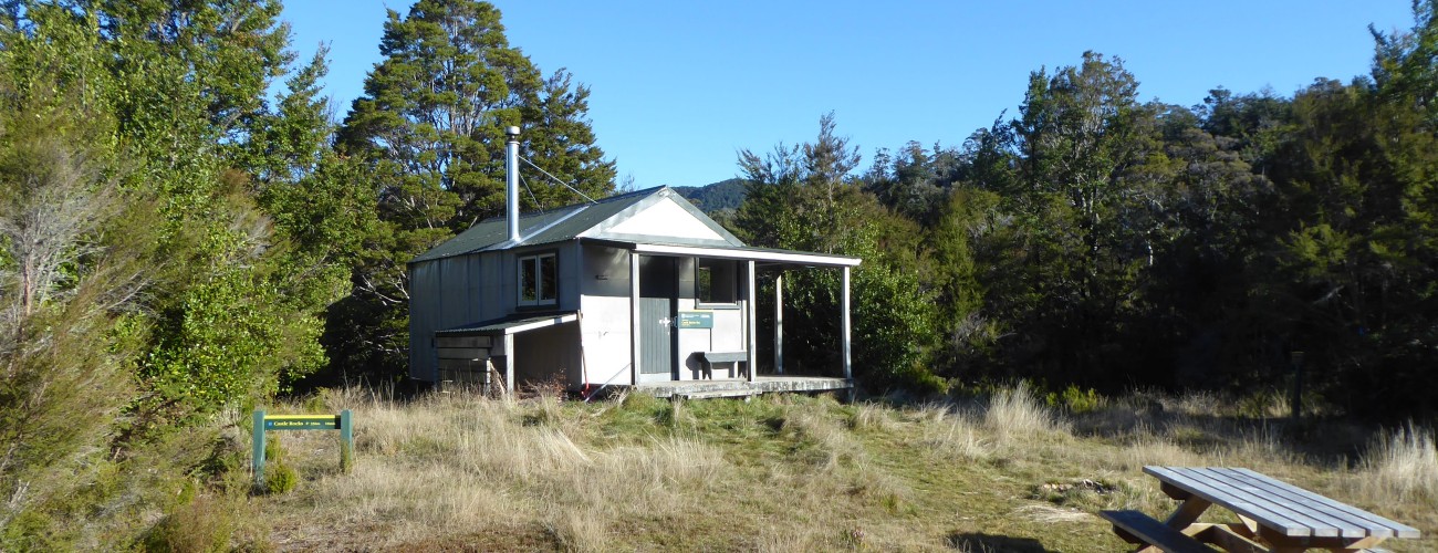
Castle Rocks Hut
Abel Tasman National Park
Castle Rocks Hut is on the Inland Track in Abel Tasman National Park. Located on a ridge above Mārahau Valley, it is commonly used as the first night stop for trampers walking the Inland Track from south to north, or as part of an overnight trip between Mārahau and Canaan Downs. Compared with the Coast Track, the Inland Track is quieter and more physically demanding, traversing upland bush and ridgelines high above the coastline.
| Details | |
| Distances | 14.3 km one way from Mārahau; 8.5 km one way from Canaan Downs car park; 13.7 km one way from Awapoto Hut |
| Time Required | 5-6 hr one way from Mārahau; 3-4 hr one way from Canaan Downs; 5 hr one way from Awapoto Hut |
| Trail Type | Tramping track |
| Physical Difficulty | Moderate |
| Uses | Walking and trail running |
| Max Elevation | 730 m from Mārahau or 1010 m from Canaan Downs |
Anchorage (Coast Track)
Walking and trail running
Moa Park
Walking and trail running
See also
Inland Track
Walking and trail running
1 hr from Nelson (Mārahau) | 1 hr 30 min from Nelson (Canaan Downs)
Though it is much closer to Canaan Downs car park, Castle Rocks Hut is most commonly accessed from Mārahau (via the Coast Track) by trampers walking the Inland Track.
Mārahau is the main southern access point for Abel Tasman National Park. From Nelson, follow SH60 through Motueka and Riwaka. A few minutes past Riwaka you’ll reach a corner where the road to Kaiteriteri turns right; instead of turning right, follow SH60 left around the corner, then turn right onto Riwaka-Sandy Bay Road, which climbs over a saddle and descends to Otuwhero Inlet and Mārahau. To get to the national park entry, follow the main (and only) road through Mārahau. A kilometre past the beachfront you’ll see plenty of signage indicating the large car park on the right, which is the primary one for Abel Tasman National Park. There are toilets and an information panel with a map that shows times and distances. Though it is large, the car park is often at capacity during the summer months.
If you’re tramping to Castle Rocks Hut from Canaan Downs, you will have a longer drive to the start (if coming from Nelson). Follow State Highway 60 to the top of Takaka Hill. Turn right onto Canaan Road, which is just past the Ngarua Cave turnoff. Canaan Road is unsealed, winding and narrow, so drive with caution. It is 11 km from the turnoff to Canaan Downs car park. Since the car park is at 750 m elevation, the trip from Canaan Downs to Mārahau via Castle Rocks Hut is primarily downhill.
Mārahau to Castle Rocks Hut
Follow Abel Tasman Coast Track for 2.7 km until just after the Tinline Bay campsite, which is where Inland Track forks to the left. From here Inland Track climbs steadily through regenerating native bush, dominated by kānuka, and lush broadleaf and ferns in the gullies. The track is generally well-formed and sandy, and the gradient is initially gentle, before steepening considerably for the next kilometre. As you climb you’ll enjoy occasional glimpses towards Anchorage and back across Tasman Bay.
After around 2 hr 15 min (4 km) from the Coast Track turnoff you will reach a track junction where a track heads downhill to reconnect with the Coast Track near Anchorage (2 hr 30 min away). Holyoake Clearing Shelter, at 600 m elevation, is a further 15 min past this junction.
From Holyoake Clearing the track is rougher, but the gradient is largely undulating with only short uphill sections. The surrounding bush is less disturbed and contains some attractive rimu. Keep an eye and an ear out for kaka and kakariki, both of which are increasing in numbers thanks to Project Janszoon. The track dips in and out of a few stream gullies along the 6.2 km (2-3 hr) to Castle Rocks Hut.
Castle Rocks Hut stands in a relatively sunny spot on the edge of a small clearing.
| Castle Rocks Hut | |||
| Hut Type | Standard Hut | Capacity | 8 |
| Bookings | Not required; first in, first served | Elevation | 720 m |
Castle Rocks themselves are a 20 min walk from the hut. The several granite outcrops that stand on the edge of the ridge provide impressive views over Mārahau Valley and further out across Tasman Bay. Note that the track to the rocks is in poor condition, with erosion making some sections difficult.
Castle Rocks Hut to Awapoto Hut
Distance: 13.7 km • Time Required: 4-5 hr
The track climbs up the broadly-sloping Evans Ridge and is uphill most of the way with varying degrees of steepness. The track is not well-graded, with ruts and roots adding to the physical challenge. Dracophyllum becomes numerous a little further up the track and mountain cedar (pahautea) becomes prominent above 1000 m elevation.
Not too long before Moa Park Shelter, the track reaches the top of the ridge (the highest point on the Inland Track; 1050 m) and flattens out. Porters Rock is a worthy 45 min side-trip from here; the track climbs to a large granite outcrop, which provides spectacular views of the interior of Abel Tasman National Park and Tasman Bay. Two minutes further along Inland Track, another short side track leads to an outcrop which allows Moa Park to be viewed from above.
Moa Park Shelter (3.6 km from Castle Rocks Hut) is located next to Table Creek. It has no bunks but you can still camp here on the flat clearings that provide enough room to pitch a tent.
Beyond Moa Park, it is a short distance to a track junction between the continuation of the Inland Track to Awapoto Hut, and Moa Park Track to Canaan Downs car park (1 hr 30 min). Turn right here and follow Inland Track through mainly beech forest as it continues northward along Evans Ridge. The ridge is undulating, passing over a high point of 1025 m, before overall descending to Awapoto Hut, positioned in a clearing at 670 m elevation, a short side track off the eastern side of Inland Track.


