Moa Park is an intriguing sub-alpine tussock basin in the highlands of Abel Tasman National Park. Located on the Inland Abel Tasman Track between Wainui Saddle and Castle Rocks Hut, visitors usually pass straight through given its proximity to the latter hut, as well as the road end at Canaan Downs. This is also due to the lack of accommodation, with Moa Park Shelter no longer being classed as a standard hut, but rather a bunk-less shelter. Despite this, Moa Park is a great location as an overnight campsite on multi-day trips along the Inland Track. It is also a worthy day-walk in its own right, via Moa Park Track from Canaan Downs.
| Details | |
| Distances (to Moa Park) | 5.2 km one way from Canaan Downs car park; 3.5 km one way from Castle Rocks Hut; 10.5 km one way from Awapoto Hut; 5 km return Moa Park to Mt Evans |
| Time Required (to Moa Park) | 4-5 hr return from Canaan Downs car park; 1 hr 30 min one way from Castle Rocks Hut; 4 hr 30 min one way from Awapoto Hut; 3 hr return Moa Park to Mt Evans |
| Trail Type | Farm track/Tramping track |
| Physical Difficulty | Moderate |
| Uses | Walking and trail running |
| Direction | Either |
| Max Elevation | 1010 m (Inland Track junction) |
| Dog Access | Dogs are prohibited in Abel Tasman National Park |
If any layers fail to load, try clearing your cache and refreshing the page.
1 hr 30 min from Nelson
The easiest way to access Moa Park is via Canaan Downs. From Nelson, follow State Highway 60 to the top of Takaka Hill. Turn right onto Canaan Road, which is just past the Ngarua Cave turnoff. Canaan Road is unsealed, windy and narrow, so drive with caution. It is 11 km from the turnoff to Canaan Downs car park.
The car park is situated at 750 m elevation. It is also the start point for Harwoods Hole Track, Rameka Track, Canaan Downs MTB tracks, and overnight tramps to Wainui Hut.
Moa Park Track begins as a farm track, steadily climbing along the forest edge above the farmland of Canaan Downs. Pages Saddle is 1 km from the car park, where Rameka Track forks to the left. After 3 km you will reach Wainui Saddle, where Wainui Track descends north toward Wainui Hut (1 hr away). Moa Park Track continues into the bush and climbs up the western side of Evans Ridge. Once at the top, the surrounding bush becomes predominantly dracophyllum, the roots of which make the track quite rugged. The track dips in and out of two creek gullies, then reaches a junction with the Inland Track. From the junction the Moa Park Track doubles as the Inland Track, and it is a short descent to Moa Park.
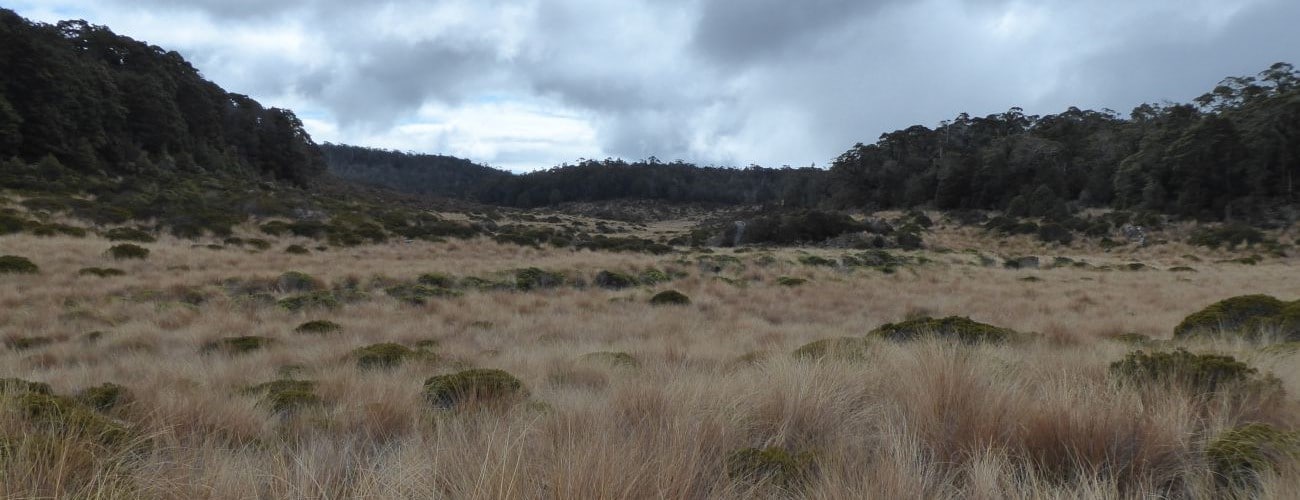
Moa Park is a basin of sub-alpine scrub and tussock amid the surrounding forested ridges. It is unusual in that it occurs at such a low elevation; situated at 1000 m, it is well below the natural tree line for the area (obviously, given that is it surrounded by tall beech and cedar). It is thought that the inability of trees to grow is caused by the microclimate created through the basin acting as a sink for cold air, as well as infertile and poorly-draining soil on the basin floor.
Moa Park Shelter is positioned on a slightly elevated site above Table Creek. The bunks were removed and the hut was downgraded to a shelter. Presumably this was partly due to the its slightly awkward position of being roughly equidistant of Castle Rocks Hut, Wainui Hut and Canaan Downs car park (nearby Holyoake Shelter suffered the same demotion, given its position between Castle Rocks Hut and Abel Tasman Coast Track). You can still camp here, and there are a few flat clearings next to the shelter that provide enough room to pitch a tent.
| Moa Park Shelter | |
| Hut Type | Shelter |
| Capacity | No bunks; space for two or three sleeping mats |
| Bookings | Not required; first in, first served |
| Fee | No fee |
| Altitude | 1000 m |
Castle Rocks Hut is a further 1 hr 30 min along the Inland Track from Moa Park. The Coast Track road end at Marahau is 13.5 km beyond Castle Rocks Hut.
Moa Park is also the start point for the route to the summit of Mt Evans, the highest point in Abel Tasman National Park (1156 m). The route is not maintained and requires good navigation skills. A return trip to the summit from Moa Park will take around 3 hr.


Moa Park is an intriguing sub-alpine tussock basin in the highlands of Abel Tasman National Park. Located on the Inland Abel Tasman Track between Wainui Saddle and Castle Rocks Hut, visitors usually pass straight through given its proximity to the latter hut, as well as the road end at Canaan Downs. This is also due to the lack of accommodation, with Moa Park Shelter no longer being classed as a standard hut, but rather a bunk-less shelter. Despite this, Moa Park is a great location as an overnight campsite on multi-day trips along the Inland Track. It is also a worthy day-walk in its own right, via Moa Park Track from Canaan Downs.
| Details | |
| Distances (from Moa Park) | 5.2 km one way from Canaan Downs car park; 3.5 km one way from Castle Rocks Hut; 10.5 km one way from Awapoto Hut; 5 km return Moa Park to Mt Evans |
| Time Required (from Moa Park) | 4-5 hr return from Canaan Downs car park; 1 hr 30 min one way from Castle Rocks Hut; 4 hr 30 min one way from Awapoto Hut; 3 hr return Moa Park to Mt Evans |
| Trail Type | Farm track/Tramping track |
| Physical Difficulty | Moderate |
| Uses | Walking and trail running |
| Direction | Either |
| Max Elevation | 1010 m (Inland Track junction) |
| Dog Access | Dogs are prohibited in Abel Tasman National Park |
1 hr 30 min from Nelson
The easiest way to access Moa Park is via Canaan Downs. From Nelson, follow State Highway 60 to the top of Takaka Hill. Turn right onto Canaan Road, which is just past the Ngarua Cave turnoff. Canaan Road is unsealed, windy and narrow, so drive with caution. It is 11 km from the turnoff to Canaan Downs car park.
The car park is situated at 750 m elevation. It is also the start point for Harwoods Hole Track, Rameka Track, Canaan Downs MTB tracks, and overnight tramps to Wainui Hut.
Moa Park Track begins as a farm track, steadily climbing along the forest edge above the farmland of Canaan Downs. Pages Saddle is 1 km from the car park, where Rameka Track forks to the left. After 3 km you will reach Wainui Saddle, where Wainui Track descends north toward Wainui Hut (1 hr away). Moa Park Track continues into the bush and climbs up the western side of Evans Ridge. Once at the top, the surrounding bush becomes predominantly dracophyllum, the roots of which make the track quite rugged. The track dips in and out of two creek gullies, then reaches a junction with the Inland Track. From the junction the Moa Park Track doubles as the Inland Track, and it is a short descent to Moa Park.
Moa Park is a basin of sub-alpine scrub and tussock amid the surrounding forested ridges. It is unusual in that it occurs at such a low elevation; situated at 1000 m, it is well below the natural tree line for the area (obviously, given that is it surrounded by tall beech and cedar). It is thought that the inability of trees to grow is caused by the microclimate created through the basin acting as a sink for cold air, as well as infertile and poorly-draining soil on the basin floor.
Moa Park Shelter is positioned on a slightly elevated site above Table Creek. The bunks were removed and the hut was downgraded to a shelter. Presumably this was partly due to the its slightly awkward position of being roughly equidistant of Castle Rocks Hut, Wainui Hut and Canaan Downs car park (nearby Holyoake Shelter suffered the same demotion, given its position between Castle Rocks Hut and Abel Tasman Coast Track). You can still camp here, and there are a few flat clearings next to the shelter that provide enough room to pitch a tent.
| Moa Park Shelter | |
| Hut Type | Shelter |
| Capacity | No bunks; space for two or three sleeping mats |
| Bookings | Not required; first in, first served |
| Fee | No fee |
| Altitude | 1000 m |
Castle Rocks Hut is a further 1 hr 30 min along the Inland Track from Moa Park. The Coast Track road end at Marahau is 13.5 km beyond Castle Rocks Hut.
Moa Park is also the start point for the route to the summit of Mt Evans, the highest point in Abel Tasman National Park (1156 m). The route is not maintained and requires good navigation skills. A return trip to the summit from Moa Park will take around 3 hr.
Updated 20 February 2019