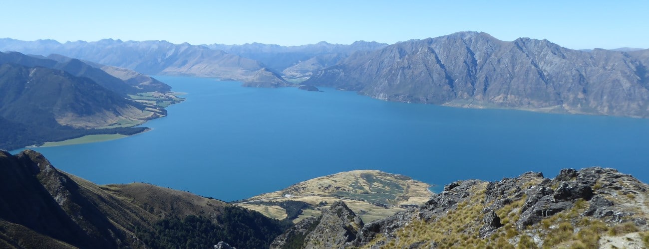
Isthmus Peak (1386 m) stands above its namesake, the narrow isthmus known as ‘The Neck’ between Lake Wanaka and Lake Hāwea. The track to the summit offers expansive views of both lakes and the surrounding peaks and ranges.
| Details | |
| Length | 9.6 km return |
| Time Required | 5-6 hr return |
| Trail Type | 4WD road |
| Physical Difficulty | Hard |
| Uses | Walking and trail running |
| Direction | Return (up and down) |
| Start Elevation | 380 m |
| Max Elevation | 1386 m |
| Dog Access | Dogs are prohibited |
If any layers fail to load, try clearing your cache and refreshing the page.
Glen Dene Ridge Track continues south along the top of the range to Matatiaho Conservation Area, from the track junction near the summit.
30 min from Wanaka
Isthmus Peak Track starts next to State Highway 6, approx. 30 km north of Wanaka. There is a small parking area, called Stewart Creek car park, on the southbound side of the highway. Don’t be surprised to find the parking area overflowing; being one of the more accessible day trips along the ‘tourist highway’, the track is quite popular during the summer months.
From the highway the track initially climbs steeply through beech trees, then sidles the slope above Glen Dene Farm. After 2.3 km the track connects with a 4WD farm track, which zig-zags up eastern face of the range, sometimes steeply. The surrounding vegetation is initially manuka scrub and then open pasture, which allows magnificent views over Lake Hāwea for the whole climb. Towards the top the track enters tussockland and skirts around tilted schist outcrops.
Near the top of the range there is a track junction; follow the DOC signpost and turn right, following the ridgeline for the remaining distance to the summit.
The summit is marked by a wooden pole and overlooks Lake Wanaka and The Neck. Enjoy the spectacular 360° views of both lakes and the surrounding mountains.
Return the way you came.
Isthmus Peak is an alpine environment, so proper preparation and care should be made to ensure a safe trip. The track reaches a high elevation and is exposed the entire way, so good outdoor clothing is essential. Be sure to check the alpine weather forecast before you go.
The track crosses terrain that is avalanche-prone from autumn to spring; check conditions on the avalanche advisory website before you go.
There are no water sources along the track so make sure you carry plenty of your own.
See the Mountain Safety Council website for useful information on preparing for the outdoors.


Isthmus Peak (1386 m) stands above its namesake, the narrow isthmus known as ‘The Neck’ between Lake Wanaka and Lake Hāwea. The track to the summit offers expansive views of both lakes and the surrounding peaks and ranges.
| Details | |
| Length | 9.6 km return |
| Time Required | 5-6 hr return |
| Trail Type | 4WD road |
| Physical Difficulty | Hard |
| Uses | Walking and trail running |
| Direction | Return (up and down) |
| Start Elevation | 380 m |
| Max Elevation | 1386 m |
| Dog Access | Dogs are prohibited |
30 min from Wanaka
Isthmus Peak Track starts next to State Highway 6, approx. 30 km north of Wanaka. There is a small parking area, called Stewart Creek car park, on the southbound side of the highway. Don’t be surprised to find the parking area overflowing; being one of the more accessible day trips along the ‘tourist highway’, the track is quite popular during the summer months.
From the highway the the track initially climbs steeply through beech trees, then sidles the slope above Glen Dene Farm. After 2.3 km the track connects with a 4WD farm track, which zig-zags up eastern face of the range, sometimes steeply. The surrounding vegetation is initially manuka scrub and then open pasture, which allows magnificent views over Lake Hāwea for the whole climb. Towards the top the track enters tussockland and skirts around tilted schist outcrops.
Near the top of the range there is a track junction; follow the DOC signpost and turn right, following the ridgeline for the remaining distance to the summit.
The summit is marked by a wooden pole and overlooks Lake Wanaka and The Neck. Enjoy the spectacular 360° views of both lakes and the surrounding mountains.
Return the way you came.
Isthmus Peak is an alpine environment, so proper preparation and care should be made to ensure a safe trip. The track reaches a high elevation and is exposed the entire way, so good outdoor clothing is essential. Be sure to check the alpine weather forecast before you go.
The track crosses terrain that is avalanche-prone from autumn to spring; check conditions on the avalanche advisory website before you go.
There are no water sources along the track so make sure you carry plenty of your own.
See the Mountain Safety Council website for useful information on preparing for the outdoors.
Glen Dene Ridge Track continues south along the top of the range to Matatiaho Conservation Area, from the track junction near the summit.
Updated 15 April 2020