St Arnaud Range Track climbs from Lake Rotoiti to Parachute Rocks and the top of St Arnaud Range, in Nelson Lakes National Park. The track is a physically-demanding day walk, but the views from the top are breathtaking. The name ‘parachute’ comes from the resemblance of the scree slope in the gully immediately north of the track, when viewed from St Arnaud and the lake edge below.
| Trail Details | |
| Length | 10.5 km return |
| Time Required | 4-5 hr return |
| Trail Type | Tramping track/Poled route |
| Physical Difficulty | Hard |
| Uses | Walking and trail running |
| Direction | Return (up and down) |
| Start Elevation | 620 m |
| Max Elevation | 1787 m |
| Dog Access | Dogs are prohibited in Nelson Lakes National Park |
If any layers fail to load, try clearing your cache and refreshing the page.
This elevation profile should be considered approximate. Its accuracy is determined by the quality of data available.
Honeydew Walk
Walking and trail running
Lakehead Track
Walking and trail running
Loop Track
Walking and trail running
1 hr 5 min from Nelson | 1 hr 20 min from Blenheim
St Arnaud is the gateway to Lake Rotoiti and Nelson Lakes National Park, and is 75 km southwest of Nelson and 103 km west of Blenheim. St Arnaud Range Track begins at the eastern end of Kerr Bay on Lake Rotoiti. There is plenty of parking at the lake edge and next to the DOC campground. You will see a large information board with a map, and times and distances of the various tracks in the area.
St Arnaud Range Track forks to the left from Lakehead Track after 200 m, and then again from Honeydew Track after a further 300 m. The lower slopes of the range are forested in an attractive mix of silver and red beech, with putaputaweta, lemonwood and other broadleaf species in the sub-canopy. The track crosses a series of moraine terraces that indicate the advance and retreat cycles of the glacier that carved out the valley and the depression that the lake now fills. After 1.3 km of gentle climbing Loop Track forks to the right, (eventually linking back with Lakehead Track back on the lake edge) and St Arnaud Range Track heads left across the ephemeral Borlase Stream. The track zig-zags up a truncated spur for 1-2 hr.
The zig-zags become progressively narrower as the tree line is approached. Take note of the altitudinal stratification of the beech forest; red beech transitions to silver beech and then to stunted mountain beech. The tree line is at 1420 m elevation, immediately above which a rocky outcrop offers a great lookout and turn around point if you think the remaining climb to the top of the range is a bit too far.
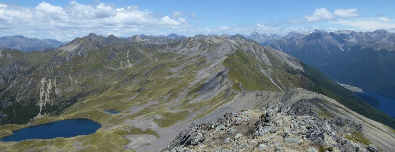
From here the track is a poled route, heading straight up the range through alpine grass and tussock. This is the steepest section of the track; be very cautious ascending and descending in winter. The top of the range is 1705 m elevation. Here you will enjoy spectacular views west across Lake Rotoiti and east into the unnamed tarn-dotted basins on the eastern side of St Arnaud Range.
You can continue south along the range for 15 min to a high point (1787 m elevation). The range is craggy and narrow, so watch your step, especially when there is snow and ice about. It is possible to head further south along the ridge to the basin that hosts Rainbow Skifield, and Mt McRae (1878 m). This will involve several hours of travel along the top of the range and requires clear, calm weather.
Return the way you came.
St Arnaud Range is an alpine route, so proper preparation and care should be made to ensure a safe trip. This track reaches a high elevation and is very exposed above the treeline, so proper outdoor clothing is essential. Be sure to check the Nelson Lakes alpine weather forecast before you go (the DOC visitor centre at St Arnaud provides daily updates on the weather outlook). Take extra care in snowy or icy conditions as the steep sections toward the top of the range can be very slippery. Wasps are often in high numbers during summer; be sure to carry antihistamine if you are allergic.
See the Mountain Safety Council website for useful information on preparing for the outdoors.


St Arnaud Range Track climbs from Lake Rotoiti to Parachute Rocks and the top of St Arnaud Range, in Nelson Lakes National Park. The track is a physically-demanding day walk, but the views from the top are breathtaking. The name ‘parachute’ comes from the resemblance of the scree slope in the gully immediately north of the track, when viewed from St Arnaud and the lake edge below.
| Details | |
| Length | 10.5 km return |
| Time Required | 4-5 hr return |
| Trail Type | Tramping track/Poled route |
| Physical Difficulty | Hard |
| Uses | Walking and trail running |
| Direction | Return (up and down) |
| Start Elevation | 620 m |
| Max Elevation | 1787 m |
| Dog Access | Dogs are prohibited in Nelson Lakes National Park |
1 hr 5 min from Nelson | 1 hr 20 min from Blenheim
St Arnaud is the gateway to Lake Rotoiti and Nelson Lakes National Park, and is 75 km southwest of Nelson and 103 km west of Blenheim. St Arnaud Range Track begins at the eastern end of Kerr Bay on Lake Rotoiti. There is plenty of parking at the lake edge and next to the DOC campground. You will see a large information board with a map, and times and distances of the various tracks in the area.
St Arnaud Range Track forks to the left from Lakehead Track after 200 m, and then again from Honeydew Track after a further 300 m. The lower slopes of the range are forested in an attractive mix of silver and red beech, with putaputaweta, lemonwood and other broadleaf species in the sub-canopy. The track crosses a series of moraine terraces that indicate the advance and retreat cycles of the glacier that carved out the valley and the depression that the lake now fills. After 1.3 km of gentle climbing Loop Track forks to the right, (eventually linking back with Lakehead Track back on the lake edge) and St Arnaud Range Track heads left across the ephemeral Borlase Stream. The track zig-zags up a truncated spur for 1-2 hr.
The zig-zags become progressively narrower as the tree line is approached. Take note of the altitudinal stratification of the beech forest; red beech transitions to silver beech and then to stunted mountain beech. The tree line is at 1420 m elevation, immediately above which a rocky outcrop offers a great lookout and turn around point if you think the remaining climb to the top of the range is a bit too far.
From here the track is a poled route, heading straight up the range through alpine grass and tussock. This is the steepest section of the track; be very cautious ascending and descending in winter. The top of the range is 1705 m elevation. Here you will enjoy spectacular views west across Lake Rotoiti and east into the unnamed tarn-dotted basins on the eastern side of St Arnaud Range.
You can continue south along the range for 15 min to a high point (1787 m elevation). The range is craggy and narrow, so watch your step, especially when there is snow and ice about. It is possible to head further south along the ridge to the basin that hosts Rainbow Skifield, and Mt McRae (1878 m). This will involve several hours of travel along the top of the range and requires clear, calm weather.
Return the way you came.
St Arnaud Range is an alpine route, so proper preparation and care should be made to ensure a safe trip. This track reaches a high elevation and is very exposed above the treeline, so proper outdoor clothing is essential. Be sure to check the Nelson Lakes alpine weather forecast before you go (the DOC visitor centre at St Arnaud provides daily updates on the weather outlook). Take extra care in snowy or icy conditions as the steep sections toward the top of the range can be very slippery. Wasps are often in high numbers during summer; be sure to carry antihistamine if you are allergic.
See the Mountain Safety Council website for useful information on preparing for the outdoors.
Honeydew Walk
Walking and trail running
Lakehead Track
Walking and trail running
Loop Track
Walking and trail running
Updated 29 January 2019