The Sanctuary Circuit circumnavigates the perimeter of the pest-proof fence of the Brook Waimārama Sanctuary. It is a half-day walk over challenging topography and features some of the steepest sections of walking track of anywhere within close range of the city.
| Details | |
| Length | 14.1 km |
| Time Required | 4-5 hr |
| Trail Type | 4WD track |
| Physical Difficulty | Hard |
| Uses | Walking and trail running |
| Direction | Anti-clockwise recommended |
| Start Elevation | 90 m |
| Max Elevation | 873 m |
| Dog Access | Dogs are prohibited in Brook Conservation Area |
If any layers fail to load, try clearing your cache and refreshing the page.

10 min from central Nelson
From central Nelson, head up the Brook Valley along Brook St. Continue through Brook Motor Camp, following the Brook Waimārama Sanctuary signage. Just to the right of the sanctuary visitor centre and below the bottom Dam there is a car park. The circuit starts at the footbridge here.
Due to the steepness of the terrain, the circuit is best walked in an anti-clockwise direction (i.e. heading up to Jenkins Hill first, rather than Third House).
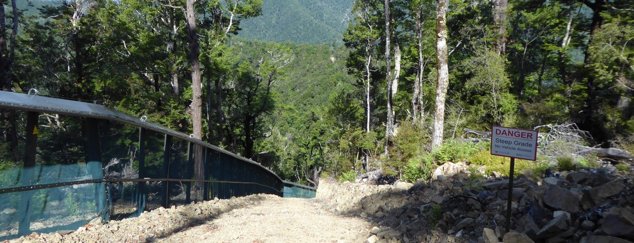
At the Brook Waimārama Sanctuary Visitor Centre, cross the bridge at the car park. Follow the track back underneath the bridge and along the fence. The fence turns to the left and heads straight up the base of the spur, and the track follows, climbing the very steep hillside through a series of wooden steps. It then connects to a 4WD vehicle track that runs alongside the fence line from here on, continuing at a reasonably consistent uphill gradient. After the first kilometre of climbing, you will have gained 285 m elevation (a gradient of nearly 30%). The track surface consists of clay and loose gravel, and is rutted in places, especially after rain.
A short section of slight downhill offers brief respite, then it’s on to the steepest part of the climb, where you will gain 100 m elevation in a little over 300 m distance. This section is challenging to climb, and even harder to descend, hence the recommendation to complete the circuit in this direction. Above here, the track enters beech forest, and the climb continues at varying degrees of steepness to the track junction at the top of Jenkins Hill. Note that MTB is not possible between the visitor centre and the top of Jenkins Hill; the terrain is too steep.
You’ll reach the junction at the top of Jenkins Hill (not the true summit) after 3.5 km. From here, continue along the 4WD track along the fence is wider and smoother, as it follows the broad, beech-forested ridge the bounds the southern side of the sanctuary. You’ll pass the high point of the circuit (873 m) and from here the ridge is undulating though overall descending as it heads toward Third House. At one point the vehicle track deviates from the fence to take a less-steep path.
At Third House, you have the option to continue downhill along Coppermine Trail, though it is much the same as the fence line 4WD track, as it runs directly parallel with the latter, 30 m upslope. The descent through here is gentle. The fence 4WD track and Coppermine Trail connect again at Four Corners, 4.1 km from Third House.
At Four Corners, the fence drops away into Brook Valley along Cummins Spur at a steeper gradient, and the 4WD track follows suit. At a skid side above Eureka Park, the fence turns to the left, and the last few hundred metres down to the visitor centre are a walking track rather than 4WD track.


The Sanctuary Circuit circumnavigates the perimeter of the pest-proof fence of the Brook Waimārama Sanctuary. It is a half-day walk over challenging topography and features some of the steepest sections of walking track of anywhere within close range of the city.
| Details | |
| Length | 14.1 km |
| Time Required | 4-5 hr |
| Trail Type | 4WD track |
| Physical Difficulty | Hard |
| Uses | Walking and trail running |
| Direction | Anti-clockwise recommended |
| Start Elevation | 90 m |
| Max Elevation | 873 m |
| Dog Access | Dogs are prohibited in Brook Conservation Area |
10 min from Nelson
From central Nelson, head up the Brook Valley along Brook St. Continue through Brook Motor Camp, following the Brook Waimarama Sanctuary signage. Just to the right of the sanctuary visitor centre and below the bottom Dam there is a car park. The circuit starts at the footbridge here.
Due to the steepness of the terrain, the circuit is best walked in an anti-clockwise direction (i.e. heading up to Jenkins Hill first, rather than Third House).
At the Brook Waimārama Sanctuary Visitor Centre, cross the bridge at the car park. Follow the track back underneath the bridge and along the fence. The fence turns to the left and heads straight up the base of the spur, and the track follows, climbing the very steep hillside through a series of wooden steps. It then connects to a 4WD vehicle track that runs alongside the fence line from here on, continuing at a reasonably consistent uphill gradient. After the first kilometre of climbing, you will have gained 285 m elevation (a gradient of nearly 30%). The track surface consists of clay and loose gravel, and is rutted in places, especially after rain.
A short section of slight downhill offers brief respite, then it’s on to the steepest part of the climb, where you will gain 100 m elevation in a little over 300 m distance. This section is challenging to climb, and even harder to descend, hence the recommendation to complete the circuit in this direction. Above here, the track enters beech forest, and the climb continues at varying degrees of steepness to the track junction at the top of Jenkins Hill. Note that MTB is not possible between the visitor centre and the top of Jenkins Hill; the terrain is too steep.
You’ll reach the junction at the top of Jenkins Hill (not the true summit) after 3.5 km. From here, continue along the 4WD track along the fence is wider and smoother, as it follows the broad, beech-forested ridge the bounds the southern side of the sanctuary. You’ll pass the high point of the circuit (873 m) and from here the ridge is undulating though overall descending as it heads toward Third House. At one point the vehicle track deviates from the fence to take a less-steep path.
At Third House, you have the option to continue downhill along Coppermine Trail, though it is much the same as the fence line 4WD track, as it runs directly parallel with the latter, 30 m upslope. The descent through here is gentle. The fence 4WD track and Coppermine Trail connect again at Four Corners, 4.1 km from Third House.
At Four Corners, the fence drops away into Brook Valley along Cummins Spur at a steeper gradient, and the 4WD track follows suit. At a skid side above Eureka Park, the fence turns to the left, and the last few hundred metres down to the visitor centre are a walking track rather than 4WD track.
Updated 26 January 2021