Avalanche Peak
Arthur’s Pass National Park
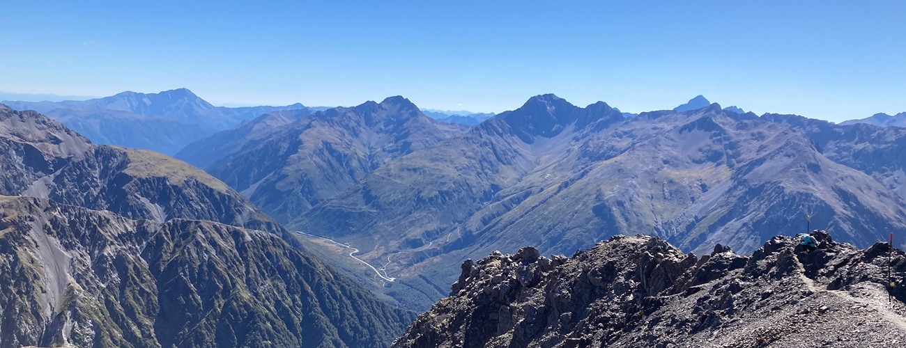
Avalanche Peak (1833 m) is a challenging day hike beginning in Arthur’s Pass village. The summit provides spectacular views of the surrounding peaks and ranges, especially Mt Rolleston and the Crow Glacier.
| Details | |
| Length | 3.1 km one way from visitor centre to Avalanche Peak summit; 4.1 km Avalanche Peak summit to Devils Punchbowl car park via Scotts Route |
| Time Required | 2-4 hr one way from visitor centre to Avalanche Peak summit; 1 hr 30 min-3 hr Avalanche Peak summit to Devils Punchbowl car park via Scotts Route |
| Trail Type | Tramping track/Poled route |
| Physical Difficulty | Hard |
| Uses | Walking and trail running |
| Start Elevation | 750 m |
| Max Elevation | 1833 m |
Avalanche Peak Route-Scotts Route circuit does not connect to any other official tracks. When conditions allow it, experienced hikers can continue south along the range to Mt Bealey.
1 hr 45 min from Christchurch
Avalanche Peak can be climbed via either Avalanche Peak Route or Scotts Route, and the two can be combined to form a circuit. Avalanche Peak Route begins behind the Arthur’s Pass Visitor Centre, while Scotts Route begins 800 m further along SH73, at the Devils Punchbowl car park.
Avalanche Peak Route begins behind the Arthur’s Pass Visitor Centre, climbing steeply through mountain beech forest alongside Avalanche Creek, which tumbles through the gully on your right. The route ascends sharply to the tree line at around 1300 m, where the forest gives way to subalpine scrub and tussock. Above here, a yellow-poled route continues through snow tussock along the narrow ridge, with Rough Creek Valley dropping steeply away to your left. As you approach the summit, the route steepens as it climbs over scree and through bluffs. Just below the summit, Scotts Route joins from the right (marked with orange poles), forming an alternative return route for a rewarding circuit.
The summit of Avalanche Peak offers panoramic views across to Mt Rolleston, the Crow Glacier, and the surrounding peaks of Arthur’s Pass National Park. For a circuit, return via Scotts Route, which is similar to Avalanche Peak Route but descends slightly more gradually back to the highway near the village. Head back through the village to return to where you started.
Arthur’s Pass is a stronghold for kea, which you’ll often see or hear overhead. Rock wren can occasionally be seen above the tree line.
Avalanche Peak to Mt Bealey
Traversing the range between Avalanche Peak and Mt Bealey is an advanced alpine route, suitable only in clear weather and for those with strong off-track navigation and scrambling experience. From Avalanche Peak, descend south along the ridge and follow the crest toward Mt Lyell. The route remains relatively straightforward across Mt Lyell, but the final kilometre before Mt Bealey is exposed and demanding — a serrated ridge of narrow crags, loose rock, and steep drop-offs on both sides. In snow or ice conditions, a slip here could be fatal. Once at Mt Bealey, you can descend back to Arthur’s Pass Village via the Mt Bealey Route.


Avalanche Peak is an alpine environment, so proper preparation and care should be taken to ensure a safe trip. The route reaches a high elevation and is exposed above the tree line, so proper outdoor clothing is essential. You must always be prepared for freezing conditions and take extreme care if snow and ice and are present. Extreme care is required on the upper slopes of Avalanche Peak, which features loose scree and sheer bluffs. Attempt this climb only in good weather and if you’re confident in alpine terrain. Make sure you carry plenty of water with you as there are no water sources on the way up.
See the Mountain Safety Council website for useful information on preparing for the outdoors.
Avalanche Peak Route-Scotts Route circuit does not connect to any other official tracks. When conditions allow it, experienced hikers can continue south along the range to Mt Bealey.