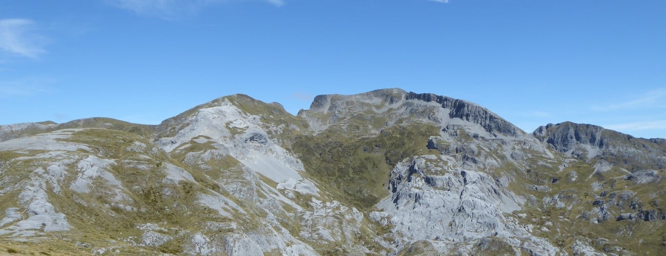
Tu Ao Wharepapa / Mt Arthur (1795 m) is one of the highest peaks in Kahurangi National Park and forms part of the iconic skyline on Nelson’s western horizon. Mt Arthur and the neighboring Twins (1796 m and 1809 m) comprise fascinating karst landscapes, with glacially-molded cirques, spectacular outcrops of ancient marble, and rolling tussock ridges. The mountain is riddled with caves and sinkholes, and is the location of New Zealand’s deepest cave systems (Nettlebed and Ellis Basin), the exploration of which are ongoing. The mountain and wider area contain rare and nationally-significant ecosystems, which are home to a high number of threatened endemic species. Mt Arthur is named after Captain Arthur Wakefield, who played a significant role in the European settlement of Nelson, though it was known as Tu Ao Wharepapa to local Maori, due to its flat summit resembling the roof of a meeting house.
| Details | |
| Distances (from Flora car park) | 4 km one way to Mt Arthur Hut; 17.3 km to Mt Arthur summit (return); 12.7 km one way to Salisbury Lodge (via Mt Arthur Hut and Gordon’s Pyramid); 10.4 km one way to Ellis Basin Hut; 2 km one way to Flora Hut |
| Time Required (from Flora car park) | 1 hr 15 min one way to Mt Arthur Hut; 5-7 hr to Mt Arthur summit (return); 5 hr one way to Salisbury Lodge (via Mt Arthur Hut and Gordon’s Pyramid); 4 hr 30 min one way to Ellis Basin Hut; 45 min one way to Flora Hut |
| Trail Type | Walking track to Mt Arthur Hut; Poled route above hut |
| Physical Difficulty | Moderate (Mt Arthur Hut) to Hard (Mt Arthur summit and Ellis Basin) |
| Uses | Walking and trail running |
| Start Elevation | 930 m (Flora car park) |
| Max Elevation | 1310 m (Mt Arthur Hut) or 1795 m (Mt Arthur summit) |
| Dog Access | Dogs are prohibited in Kahurangi National Park |
If any layers fail to load, try clearing your cache and refreshing the page.
This elevation profile should be considered approximate. Its accuracy is determined by the quality of data available.

1 hr 15 min from Nelson
Flora car park is the starting point for Mt Arthur Track and Mt Arthur Summit Route. Flora car park is located 10 km up Graham Valley Road at 930 m elevation. Graham Valley Road begins off Motueka River West Bank Road near Ngatimoti, and is approximately 65 km from Nelson and 21 km from Motueka. Be aware that the road is steep, narrow and unsealed, and can be icy in winter. A 4WD vehicle is recommended. It is also prone to slips, so check the DOC or TDC websites for road access updates.
At the car park there is a toilet and a shelter named Flora Kiosk, where you can view maps and track information, and enter your intentions in the logbook.
Begin by following Flora Track (a 4WD road) from Flora car park. You will quickly reach Flora Saddle (975 m), where Mt Arthur Track forks to the left. Mt Arthur Track is smooth and wide, and climbs gently onto the crest of a ridge, which it follows in a southwest direction through dracophyllum and stunted mountain beech. After about a kilometre on the ridge the track steepens a little and winds up through elegant silver beech trees towards Mt Arthur Hut. You will reach the hut, which sits just below the tree line at 1310 m, after around 1 hr 15 min.
Mt Arthur Hut is popular given its easy access. It is not a large hut, so do not be surprised to find it full. There is space for only a couple of tents outside, though you can also erect tent flies among the trees just downhill of the hut.
| Mt Arthur Hut | |
| Hut Type | Serviced Hut |
| Capacity | 8 bunks |
| Bookings | Not required; first in, first served |
| Fee | 1 Serviced Hut Ticket |
| Altitude | 1310 m |
On the return leg, you can retrace you steps back the way you came. Alternatively, you can return via Flora Hut. For the latter option, continue just uphill of the Mt Arthur Hut to a track junction, where you can turn off to Flora Hut. It is 2.8 km (1 hr) to Flora Hut and downhill most of the way. The first kilometre passes through tussock, which allows good views of Mt Arthur and Gordon’s Pyramid. The track then enters beech forest, through which it continues for the remainder of the decent to Flora Hut. The track is tramping grade and is certainly more challenging than Mt Arthur Track, so it would be wise to wear decent outdoor footwear if you intend to do this circuit. Once at Flora Hut, head back along the 4WD road for 2 km to Flora car park.
Just above the hut is a track junction between Mt Arthur Summit Route and the track down to Flora Hut. Turn left here, and climb up onto the ridge amid tussock and alpine shrubs. Though categorised as a route, the track is well-worn and marked with poles. You will soon reach an impressive section of marble pavement, where you’ll get the first glimpse of the summit and enjoy good views in all directions. The ridge is undulating at first, then rises steeply above the eastern side of Horseshoe Basin. 1.9 km from Mt Arthur Hut you will reach the turnoff to Gordon’s Pyramid Route, which descends west into the pockmarked topography of Horseshoe Basin, then takes a direct path over the summit of Gordon’s Pyramid (1489 m), and drops down to the Tableland and Salisbury Lodge (6.8 km away).
Further along the ridge, the route transverses a few sections of loose scree that require a bit of care. The ridge narrows and drops into a low saddle overlooked by a massive marble outcrop, with shattered rock sliding from its base into a basin that drops very steeply to the left. The route climbs steeply to the right of this outcrop, and then over and around deeply-fissured marble, to the turnoff to Ellis Basin Route; the latter branches off to the left, eventually reaching Ellis Basin Hut (1 hr 30 min away).
You’ll reach the saddle between Winter Peak and a steep bluff that drops very steeply into Ellis Basin to the south. The last few hundred metres to the summit crest of Mt Arthur are a steep rocky scramble. Note that the area below the summit is susceptible to avalanches in winter, so you will need to assess the risk before traversing.
The summit is gently sloping and covered in flat marble rocks. On fine days it is a really enjoyable place to have lunch and admire the spectacular views south towards The Twins, west to the interior of Kahurangi National Park and east across Tasman Bay. A circular cairn offers protection from the southerly wind. At 1795 m Mt Arthur is the fourth-highest peak in Kahurangi National Park, after Mt Owen massif (1875 m), Mt Snowdon (1859 m) and The Twins (1809 m and 1796 m).
Descend from the summit by returning the way you came.
Mt Arthur is an alpine environment, so proper preparation and care should be made to ensure a safe trip. The track reaches a high elevation and is exposed above the tree line, so proper outdoor clothing is essential. You must always be prepared for freezing conditions and take extreme care if snow and ice and are present. Be sure to check the forecast for Kahurangi National Park; do not rely on the Nelson or Motueka weather forecasts as the alpine conditions are likely to be drastically different. The karst landscape is riddled with caves, sinkholes and bluffs; do not deviate off the track, especially in winter, when snow will disguise the true ground surface. Consider the extra time snow will add to your trip. Basic snowcraft skills and equipment are recommended, particularly as there is risk of small avalanches below the summit crest. Make sure you record your intentions in the logbook in Flora Kiosk at Flora car park. Mobile phone coverage is possible at Flora car park and above the tree line on Mt Arthur, though it is intermittent at best throughout the remainder of the area.
See the Mountain Safety Council website for useful information on preparing for the outdoors.


Tu Ao Wharepapa / Mt Arthur (1795 m) is one of the highest peaks in Kahurangi National Park and forms part of the iconic skyline on Nelson’s western horizon. Mt Arthur and the neighboring Twins (1796 m and 1809 m) comprise fascinating karst landscapes, with glacially-molded cirques, spectacular outcrops of ancient marble, and rolling tussock ridges. The mountain is riddled with caves and sinkholes, and is the location of New Zealand’s deepest cave systems (Nettlebed and Ellis Basin), the exploration of which are ongoing. The mountain and wider area contain rare and nationally-significant ecosystems, which are home to a high number of threatened endemic species. Mt Arthur is named after Captain Arthur Wakefield, who played a significant role in the European settlement of Nelson, though it was known as Tu Ao Wharepapa to local Maori, due to its flat summit resembling the roof of a meeting house.
| Details | |
| Distances (from Flora car park) | 4 km one way to Mt Arthur Hut; 17.3 km to Mt Arthur summit (return); 12.7 km one way to Salisbury Lodge (via Mt Arthur Hut and Gordon’s Pyramid); 10.4 km one way to Ellis Basin Hut; 2 km one way to Flora Hut |
| Time Required (from Flora car park) | 1 hr 15 min one way to Mt Arthur Hut; 5-7 hr to Mt Arthur summit (return); 5 hr one way to Salisbury Lodge (via Mt Arthur Hut and Gordon’s Pyramid); 4 hr 30 min one way to Ellis Basin Hut; 45 min one way to Flora Hut |
| Trail Type | Walking track to Mt Arthur Hut; Poled route above hut |
| Physical Difficulty | Moderate (Mt Arthur Hut) to Hard (Mt Arthur summit and Ellis Basin) |
| Uses | Walking and trail running |
| Start Elevation | 930 m (Flora car park) |
| Max Elevation | 1310 m (Mt Arthur Hut) or 1795 m (Mt Arthur summit) |
| Dog Access | Dogs are prohibited in Kahurangi National Park |
This elevation profile should be considered approximate. Its accuracy is determined by the quality of data available.
1 hr 15 min from Nelson
Flora car park is the starting point for Mt Arthur Track and Mt Arthur Summit Route. Flora car park is located 10 km up Graham Valley Road at 930 m elevation. Graham Valley Road begins off Motueka River West Bank Road near Ngatimoti, and is approximately 65 km from Nelson and 21 km from Motueka. Be aware that the road is steep, narrow and unsealed, and can be icy in winter. A 4WD vehicle is recommended. It is also prone to slips, so check the DOC or TDC websites for road access updates.
At the car park there is a toilet and a shelter named Flora Kiosk, where you can view maps and track information, and enter your intentions in the logbook.
Begin by following Flora Track (a 4WD road) from Flora car park. You will quickly reach Flora Saddle (975 m), where Mt Arthur Track forks to the left. Mt Arthur Track is smooth and wide, and climbs gently onto the crest of a ridge, which it follows in a southwest direction through dracophyllum and stunted mountain beech. After about a kilometre on the ridge the track steepens a little and winds up through elegant silver beech trees towards Mt Arthur Hut. You will reach the hut, which sits just below the tree line at 1310 m, after around 1 hr 15 min.
Mt Arthur Hut is popular given its easy access. It is not a large hut, so do not be surprised to find it full. There is space for only a couple of tents outside, though you can also erect tent flies among the trees just downhill of the hut.
| Mt Arthur Hut | |
| Hut Type | Serviced Hut |
| Capacity | 8 bunks |
| Bookings | Not required; first in, first served |
| Fee | 1 Serviced Hut Ticket |
| Altitude | 1310 m |
On the return leg, you can retrace you steps back the way you came. Alternatively, you can return via Flora Hut. For the latter option, continue just uphill of the Mt Arthur Hut to a track junction, where you can turn off to Flora Hut. It is 2.8 km (1 hr) to Flora Hut and downhill most of the way. The first kilometre passes through tussock, which allows good views of Mt Arthur and Gordon’s Pyramid. The track then enters beech forest, through which it continues for the remainder of the decent to Flora Hut. The track is tramping grade and is certainly more challenging than Mt Arthur Track, so it would be wise to wear decent outdoor footwear if you intend to do this circuit. Once at Flora Hut, head back along the 4WD road for 2 km to Flora car park.


Just above Mt Arthur Hut is a track junction between Mt Arthur Summit Route and the track down to Flora Hut. Turn left here, and climb up onto the ridge amid tussock and alpine shrubs. Though categorised as a route, the track is well-worn and marked with poles. You will soon reach an impressive section of marble pavement, where you’ll get the first glimpse of the summit and enjoy good views in all directions. The ridge is undulating at first, then rises steeply above the eastern side of Horseshoe Basin. 1.9 km from Mt Arthur Hut you will reach the turnoff to Gordon’s Pyramid Route, which descends west into the pockmarked topography of Horseshoe Basin, then takes a direct path over the summit of Gordon’s Pyramid (1489 m), and drops down to the Tableland and Salisbury Lodge (6.8 km away).
Further along the ridge, the route transverses a few sections of loose scree that require a bit of care. The ridge narrows and drops into a low saddle overlooked by a massive marble outcrop, with shattered rock sliding from its base into a basin that drops very steeply to the left. The route climbs steeply to the right of this outcrop, and then over and around deeply-fissured marble, to the turnoff to Ellis Basin Route; the latter branches off to the left, eventually reaching Ellis Basin Hut (1 hr 30 min away).
You’ll reach the saddle between Winter Peak and a steep bluff that drops very steeply into Ellis Basin to the south. The last few hundred metres to the summit crest of Mt Arthur are a steep rocky scramble. Note that the area below the summit is susceptible to avalanches in winter, so you will need to assess the risk before traversing.
The summit is gently sloping and covered in flat marble rocks. On fine days it is a really enjoyable place to have lunch and admire the spectacular views south towards The Twins, west to the interior of Kahurangi National Park and east across Tasman Bay. A circular cairn offers protection from the southerly wind. At 1795 m Mt Arthur is the fourth-highest peak in Kahurangi National Park, after Mt Owen massif (1875 m), Mt Snowdon (1859 m) and The Twins (1809 m and 1796 m).


Mt Arthur is an alpine environment, so proper preparation and care should be made to ensure a safe trip. The track reaches a high elevation and is exposed above the treeline, so proper outdoor clothing is essential. You must always be prepared for freezing conditions and take extreme care if snow and ice and are present. Be sure to check the forecast for Kahurangi National Park; do not rely on the Nelson or Motueka weather forecasts as the alpine conditions are likely to be drastically different. The karst landscape is riddled with caves, sinkholes and bluffs; do not deviate off the track, especially in winter, when snow will disguise the true ground surface. Consider the extra time snow will add to your trip. Basic snowcraft skills and equipment are recommended, particularly as there is risk of small avalanches below the summit crest. Make sure you record your intentions in the logbook in Flora Kiosk at Flora car park. Mobile phone coverage is possible at Flora car park and above the treeline on Mt Arthur, though it is intermittent at best throughout the remainder of the area.
See the Mountain Safety Council website for useful information on preparing for the outdoors.
Updated 12 August 2020