Browning Hut is located on Browning Track, which doubles as Te Araroa Trail, in Mt Richmond Forest Park. The hut is great for overnight trips from Hacket car park, and is a convenient stopover on multi-day tramps along the Mt Richmond section of Te Araroa Trail. Browning Hut is located between Hacket Hut and Totara Saddle, the latter being where Browning Track, Pelorus Track and Te Araroa Trail converge. Browning Hut is the third-closest hut to Nelson City.
| Details | |
| Distances | 8.1 km one way from Hacket car park; 3.4 km one way from Hacket Hut |
| Time Required | 3 hr one way from Hacket car park; 1 hr one way from Hacket Hut |
| Trail Type | Tramping track |
| Physical Difficulty | Moderate |
| Uses | Walking and trail running |
| Direction | Either |
| Start Elevation | 120 m (Hacket car park) |
| Finish Elevation | 480 m (Browning Hut) |
| Dog Access | Permit required for Mt Richmond Forest Park; see Nelson DOC office |
If any layers fail to load, try clearing your cache and refreshing the page.
30 min from Nelson
Browning Hut is most easily accessed via Hacket Track, which begins at Hacket car park, 8 km up Aniseed Valley Road (25 min drive from Richmond). There are toilets at the car park and a bridge across the Roding River, beneath which there is a great swimming hole to cool off in during summer.
Hacket Track bridges Roding River at the car park and heads east up Hacket Valley, following the true right of Hacket Creek through pine forest. A suspension bridge crosses the creek and the road becomes a walking track, continuing on the true left through native bush and crossing into Mt Richmond Forest Park.
From here until the Whispering Falls turnoff, the valley narrows and the track sidles the steep slope above the creek. Erosion is a serious issue along here; in places the creek has undercut the bank beneath the track, causing it to fall away to the creekbed a few metres below. Some parts are very narrow and there are limited places to go if you need pass others, so proceed with caution. A few hundred metres further on, the track crosses into the Dun Mountain Mineral Belt, where the surrounding vegetation becomes stunted and outcrops of ultramafic rock (namely dunite, rodingite and serpentinite) jut out from the hillside above the track.
Hacket Track continues past the Whispering Falls and Old Chrome Road Circuit turnoffs, along Hacket Creek through mineral belt scrub (including kānuka, celery pine and lancewood) and a little further enters douglas fir plantation. You will reach the junction with Browning Track 4.8 km from the car park. Turn left here.
Browning Track crosses Hacket Creek and Browning Creek soon after. Browning Creek is crossed again and then the track reaches a junction with Te Araroa Trail. Turn left to get to Browning Hut; turning right will take you to Hacket Hut, 1.3 km away. From here to Browning Hut, Browning Track doubles as Te Araroa Trail. The track crosses Browning Creek again, and heads through native forest, deviating from Browning Creek and instead climbing in and out of the unnamed creek gully. You will reach a section where you will need to clamber over car-size boulders have crashed down into the creek gully. The remainder of the distance to the hut passes through attractive native forest that contains beech, rimu, totara.
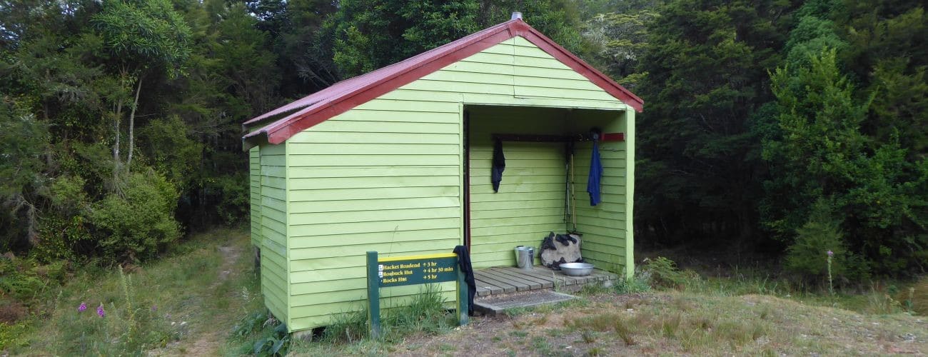
Browning Hut is located on the edge of a clearing, 25 m from Browning Creek, the hut’s water source. Do not be surprised to find the hut at full capacity, given its location on the Te Araroa Trail.
| Browning Hut | |
| Hut Type | Standard Hut |
| Capacity | 8 bunks |
| Bookings | Not required; first in, first served |
| Fee | 1 Standard Hut Ticket |
| Altitude | 480 m |
From Browning Hut it is about 40 min along Te Araroa Trail to Totara Saddle. A track junction at the saddle gives you the option to continue along Te Araroa Trail to Rocks Hut, or follow Pelorus Track to Roebuck Hut.
Browning Hut to Roebuck Hut
Pelorus Track to Roebuck Hut continues east through the saddle and sidles the forest hillside on the southern side of the valley above Roebuck Creek. The track is not benched, though is relatively gentle in gradient, as it stays around the 600 m elevation contour for nearly four kilometres. Tall beech forest allows only occasional views north toward the other side of the valley. As you near Roebuck Hut, the track descends a spur and a swingbridge crosses Pelorus River to reach Roebuck Hut. The hut stands in a grassy clearing above the confluence of Roebuck Creek and Pelorus River. The stunningly-clear Pelorus River is great for swimming if you can stand the sandflies. Browning Hut to Roebuck Hut is 8.7 km, and will take you 3-4 hours.
Browning Hut to Rocks Hut
Te Araroa Trail to Rocks Hut climbs steeply and roughly north out of the saddle, and follows the crest of the ridge northeast. Soon the track emerges onto an area of mineral belt tussock and scrub, which allow open views back to Mt Starveall. The track dips into a low saddle, then climbs up to 1030 m, the highest elevation it gets to. From here the track is undulating though gently descending, as it climbs over and around a series of hummocks and rock outcrops that dot the ridge (a nearby point on the ridge appropriately named The Rocks, and is the hut’s namesake). The majority of the track passes attractive beech forest with a thick undergrowth of crown ferns, though you will also encounter a couple of sections where the forest has been severely damaged by wind. Occasional openings in the trees allow good views northwest toward Tasman Bay. Browning Hut to Rocks Hut is 10.7 km, and will take you 5-6 hours.


Browning Hut is located on Browning Track, which doubles as Te Araroa Trail, in Mt Richmond Forest Park. The hut is great for overnight trips from Hacket car park, and is a convenient stopover on multi-day tramps along the Mt Richmond section of Te Araroa Trail. Browning Hut is located between Hacket Hut and Totara Saddle, the latter being where Browning Track, Pelorus Track and Te Araroa Trail converge. Browning Hut is the third-closest hut to Nelson City.
| Details | |
| Distances | 8.1 km one way from Hacket car park; 3.4 km one way from Hacket Hut |
| Time Required | 3 hr one way from Hacket car park; 1 hr one way from Hacket Hut |
| Trail Type | Tramping track |
| Physical Difficulty | Moderate |
| Uses | Walking and trail running |
| Direction | Either |
| Start Elevation | 120 m (Hacket car park) |
| Finish Elevation | 480 m (Browning Hut) |
| Dog Access | Permit required for Mt Richmond Forest Park; see Nelson DOC office |
30 min from Nelson
Browning Hut is most easily accessed via Hacket Track, which begins at Hacket car park, 8 km up Aniseed Valley Road (25 min drive from Richmond). There are toilets at the car park and a bridge across the Roding River, beneath which there is a great swimming hole to cool off in during summer.
Hacket Track bridges Roding River at the car park and heads east up Hacket Valley, following the true right of Hacket Creek through pine forest. A suspension bridge crosses the creek and the road becomes a walking track, continuing on the true left through native bush and crossing into Mt Richmond Forest Park.
From here until the Whispering Falls turnoff, the valley narrows and the track sidles the steep slope above the creek. Erosion is a serious issue along here; in places the creek has undercut the bank beneath the track, causing it to fall away to the creekbed a few metres below. Some parts are very narrow and there are limited places to go if you need pass others, so proceed with caution. A few hundred metres further on, the track crosses into the Dun Mountain Mineral Belt, where the surrounding vegetation becomes stunted and outcrops of ultramafic rock (namely dunite, rodingite and serpentinite) jut out from the hillside above the track.
Hacket Track continues past the Whispering Falls and Old Chrome Road Circuit turnoffs, along Hacket Creek through mineral belt scrub (including kānuka, celery pine and lancewood) and a little further enters douglas fir plantation. You will reach the junction with Browning Track 4.8 km from the car park. Turn left here.
Browning Track crosses Hacket Creek and Browning Creek soon after. Browning Creek is crossed again and then the track reaches a junction with Te Araroa Trail. Turn left to get to Browning Hut; turning right will take you to Hacket Hut, 1.3 km away. From here to Browning Hut, Browning Track doubles as Te Araroa Trail. The track crosses Browning Creek again, and heads through native forest, deviating from Browning Creek and instead climbing in and out of the unnamed creek gully. You will reach a section where you will need to clamber over car-size boulders have crashed down into the creek gully. The remainder of the distance to the hut passes through attractive native forest that contains beech, rimu, totara.
Browning Hut is located on the edge of a clearing, 25 m from Browning Creek, the hut’s water source. Do not be surprised to find the hut at full capacity, given its location on the Te Araroa Trail.
| Browning Hut | |
| Hut Type | Standard Hut |
| Capacity | 8 bunks |
| Bookings | Not required; first in, first served |
| Fee | 1 Standard Hut Ticket |
| Altitude | 480 m |
From Browning Hut it is about 40 min along Te Araroa Trail to Totara Saddle. A track junction at the saddle gives you the option to continue along Te Araroa Trail to Rocks Hut, or follow Pelorus Track to Roebuck Hut.
Browning Hut to Roebuck Hut
Pelorus Track to Roebuck Hut continues east through the saddle and sidles the forest hillside on the southern side of the valley above Roebuck Creek. The track is not benched, though is relatively gentle in gradient, as it stays around the 600 m elevation contour for nearly four kilometres. Tall beech forest allows only occasional views north toward the other side of the valley. As you near Roebuck Hut, the track descends a spur and a swingbridge crosses Pelorus River to reach Roebuck Hut. The hut stands in a grassy clearing above the confluence of Roebuck Creek and Pelorus River. The stunningly-clear Pelorus River is great for swimming if you can stand the sandflies. Browning Hut to Roebuck Hut is 8.7 km, and will take you 3-4 hours.
Browning Hut to Rocks Hut
Te Araroa Trail to Rocks Hut climbs steeply and roughly north out of the saddle, and follows the crest of the ridge northeast. Soon the track emerges onto an area of mineral belt tussock and scrub, which allow open views back to Mt Starveall. The track dips into a low saddle, then climbs up to 1030 m, the highest elevation it gets to. From here the track is undulating though gently descending, as it climbs over and around a series of hummocks and rock outcrops that dot the ridge (a nearby point on the ridge appropriately named The Rocks, and is the hut’s namesake). The majority of the track passes attractive beech forest with a thick undergrowth of crown ferns, though you will also encounter a couple of sections where the forest has been severely damaged by wind. Occasional openings in the trees allow good views northwest toward Tasman Bay. Browning Hut to Rocks Hut is 10.7 km, and will take you 5-6 hours.
Updated 05 March 2019