Lodestone is a peak on the Arthur Range, in Kahurangi National Park. Rising to 1462 m, Lodestone is a great half-day walk from Flora car park, particularly if you are seeking a quieter and shorter alternative to nearby Mt Arthur. The summit offers breathtaking views of Tasman Bay and the Arthur Range.
| Details | |
| Length | 7 km circuit from Flora car park |
| Time Required | 3-4 hr circuit from Flora car park |
| Trail Type | 4WD road/Tramping track |
| Physical Difficulty | Moderate |
| Uses | Walking |
| Direction | Either |
| Start Elevation | 930 m (Flora car park) |
| Max Elevation | 1462 m |
| Dog Access | Dogs are prohibited in Kahurangi National Park |
If any layers fail to load, try clearing your cache and refreshing the page.
1 hr 15 min from Nelson
Lodestone Circuit begins and ends at Flora car park, which is located 10 km up Graham Valley Road at 930 m elevation. Graham Valley Road begins off Motueka River West Bank Road near Ngatimoti, and is approximately 65 km from Nelson and 21 km from Motueka. Be aware that the road is steep, narrow and unsealed, and can be icy in winter. A 4WD vehicle is recommended. It is also prone to slips, so check the DOC or TDC websites for road access updates.
At the car park there is a toilet, and a shelter named Flora Kiosk, where you can view maps and track information, and enter your intentions in the logbook.
Begin by following Flora Track (the 4WD road) from Flora car park. This will take you over Flora Saddle (975 m) and down to the grassy clearing where Flora Hut stands. Lodestone Track crosses Flora Stream next to the hut, and immediately begins climbing the ridge to the north. The track follows the ridge, which is quite steep and rough in places, passing through beech and dracophyllum. You will reach the treeline (1350 m elevation) after 4.1 km.
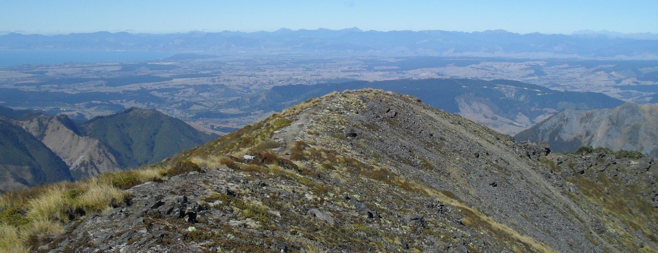
From the treeline it is a steep, rocky scramble to the pyramidal summit (1462 m), which offers 360° views across Tasman Bay and into the wilderness of Kahurangi National Park. The summit ridge is relatively flat and there is a small radio mast on the northwestern slope. On sunny days it is a good spot to have lunch. The track descends steeply off the summit and down a forested ridge for 2.4 km to complete the circuit back to Flora car park.
Lodestone is an alpine environment, so proper preparation and care should be made to ensure a safe trip. The track reaches a high elevation and is exposed above the treeline, so proper outdoor clothing is essential. You must always be prepared for freezing conditions and take extreme care if snow and ice and are present. Be sure to check the forecast for Kahurangi National Park; do not rely on the Nelson or Motueka weather forecasts as the alpine conditions are likely to be drastically different. Make sure you carry plenty of water with you as there are no water sources beyond Flora Hut.
See the Mountain Safety Council website for useful information on preparing for the outdoors.


Lodestone is a peak on the Arthur Range, in Kahurangi National Park. Rising to 1462 m, Lodestone is a great half-day walk from Flora car park, particularly if you are seeking a quieter and shorter alternative to nearby Mt Arthur. The summit offers breathtaking views of Tasman Bay and the Arthur Range.
| Details | |
| Length | 7 km circuit from Flora car park |
| Time Required | 3-4 hr circuit from Flora car park |
| Trail Type | 4WD road/Tramping track |
| Physical Difficulty | Moderate |
| Uses | Walking |
| Direction | Either |
| Start Elevation | 930 m (Flora car park) |
| Max Elevation | 1462 m |
| Dog Access | Dogs are prohibited in Kahurangi National Park |
1 hr 15 min from Nelson
Lodestone Circuit begins and ends at Flora car park, which is located 10 km up Graham Valley Road at 930 m elevation. Graham Valley Road begins off Motueka River West Bank Road near Ngatimoti, and is approximately 65 km from Nelson and 21 km from Motueka. Be aware that the road is steep, narrow and unsealed, and can be icy in winter. A 4WD vehicle is recommended. It is also prone to slips, so check the DOC or TDC websites for road access updates.
At the car park there is a toilet, and a shelter named Flora Kiosk, where you can view maps and track information, and enter your intentions in the logbook.
Begin by following Flora Track (the 4WD road) from Flora car park. This will take you over Flora Saddle (975 m) and down to the grassy clearing where Flora Hut stands. Lodestone Track crosses Flora Stream next to the hut, and immediately begins climbing the ridge to the north. The track follows the ridge, which is quite steep and rough in places, passing through beech and dracophyllum. You will reach the treeline (1350 m elevation) after 4.1 km.
From the treeline it is a steep, rocky scramble to the pyramidal summit (1462 m), which offers 360° views across Tasman Bay and into the wilderness of Kahurangi National Park. The summit ridge is relatively flat and there is a small radio mast on the northwestern slope. On sunny days it is a good spot to have lunch. The track descends steeply off the summit and down a forested ridge for 2.4 km to complete the circuit back to Flora car park.
Lodestone is an alpine environment, so proper preparation and care should be made to ensure a safe trip. The track reaches a high elevation and is exposed above the treeline, so proper outdoor clothing is essential. You must always be prepared for freezing conditions and take extreme care if snow and ice and are present. Be sure to check the forecast for Kahurangi National Park; do not rely on the Nelson or Motueka weather forecasts as the alpine conditions are likely to be drastically different. Make sure you carry plenty of water with you as there are no water sources beyond Flora Hut.
See the Mountain Safety Council website for useful information on preparing for the outdoors.
Updated 18 February 2019