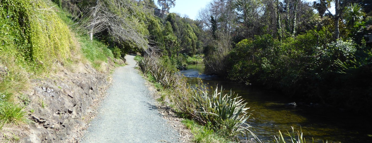
Maitai River Walkway runs alongside Maitai River through central Nelson. The walkway begins at the Maitai River mouth and extends for eight kilometres to Maitai Motor Camp in the Maitai Valley, passing through a mixture of urban and natural surroundings along the way. The walkway is a great option in summer as there are many swimming holes and picnic spots to stop at. The river’s name is a corruption of ‘Maitahi’, which refers to a particular mataī tree that grew on one of its banks.
| Details | |
| Length | 8.1 km Rutherford Park to Maitai Motor Camp; 2.8 km Riverside Pool to Sunday Hole; 11-12 km circuit with Tantragee Saddle and Brook Valley |
| Time Required (full length, one way) | 2 hr for walkers, 30 min for MTB; 2 hr 45 min for circuit with Tantragee Saddle and Brook Valley |
| Trail Type | Shared pathway/Walking track |
| Physical Difficulty | Easy |
| Uses | Walking, running, cycling and MTB (no bikes between either end of Nile St) |
| Direction | Either |
If any layers fail to load, try clearing your cache and refreshing the page.
Less than 5 min from anywhere in central Nelson
Maitai River Walkway can be accessed at numerous locations in the central city. The river mouth end connects directly to Haven Road Shared Pathway (which heads to Wakefield Quay) and Atawhai Shared Pathway (which follows QEII Drive to Atawhai). Good starting points for walks are Millers Acre and Riverside Pool. The walkway can be completed as an out-and-back trip, or you can combine it with other tracks to create a longer circuit (Botanical Hill and Tantragee Saddle are good options). At the upstream end of the walkway there are car parks on each respective side of the Maitai Motor Camp.
Most of the walkway is open to both walkers and cyclists, though as it is busy and narrow in sections, cyclists need to be respectful and courteous towards people on foot.
Beginning at the Maitai River mouth where QEII Drive bridge crosses, the walkway begins as a wide promenade alongside Rutherford Park, with terraces stepping down to the river. The walkway crosses Trafalgar St, passes Nelson Visitor Information Centre at Millers Acre, then goes beneath the Collingwood St Bridge to Riverside Pool, where there is a footbridge across to Halifax St East.
Beyond Riverside the walkway goes beneath Bridge St and runs parallel with Domett St to Hardy St, where there is a pedestrian bridge crossing the river to Hardy St East (giving quick access to Botanical Hill).
Beyond Nile St the walkway is unsealed, and undulates on the bank adjacent to Girlies swimming hole, named because it was used by Nelson College for Girls for swimming sports. No bikes are allowed along this section. The walkway follows the bend in the river and goes beneath Nile St again (Clouston Bridge), then through Hanby Park, where a boardwalk sidles the rock face above Black swimming hole. The walkway goes beneath Maitai Valley Rd at Jickells Bridge and weaves between native plantings past Dennes swimming hole around the Maitai Cricket Ground, before reaching the Maitai Valley Rd again at Gibbs Bridge. After Sunday swimming hole the it crosses pasture, then runs alongside Waahi Taakaro Golf Course and then Maitai Arboretum, across the river from the Maitai Motor Camp (where Maitai Camp swimming hole is located). At the end of the walkway a footbridge crosses the river to Maitai Valley Rd, where there is a small car park.
To create a circuit with Tantragee Saddle and Brook Valley, you can cross the fence stile at the footbridge and continue along the track that climbs steadily through Tantragee Arboretum (you can also backtrack a few hundred metres to Te Ara Kōpiko which begins adjacent to the motor camp). It’s about 2.2 km to Tantragee Saddle, and once at the top you have several options for descending into Brook Valley and reconnecting with Maitai River Walkway (which is 4.2 km from the saddle; see map for options).


Maitai River Walkway runs alongside Maitai River through central Nelson. The walkway begins at the Maitai River mouth and extends for eight kilometres to Maitai Motor Camp in the Maitai Valley, passing through a mixture of urban and natural surroundings along the way. The walkway is a great option in summer as there are many swimming holes and picnic spots to stop at. The river’s name is a corruption of ‘Maitahi’, which refers to a particular mataī tree that grew on one of its banks.
| Details | |
| Length | 8.1 km Rutherford Park to Maitai Motor Camp; 2.8 km Riverside Pool to Sunday Hole; 11-12 km circuit with Tantragee Saddle and Brook Valley |
| Time Required (full length, one way) | 2 hr for walkers, 30 min for MTB; 2 hr 45 min for circuit with Tantragee Saddle and Brook Valley |
| Trail Type | Shared pathway/Walking track |
| Physical Difficulty | Easy |
| Uses | Walking, running, cycling and MTB (no bikes between either end of Nile St) |
| Direction | Either |
Less than 5 min from anywhere in central Nelson
Maitai River Walkway can be accessed at numerous locations in the central city. The river mouth end connects directly to Haven Road Shared Pathway (which heads to Wakefield Quay) and Atawhai Shared Pathway (which follows QEII Drive to Atawhai). Good starting points for walks are Millers Acre and Riverside Pool. The walkway can be completed as an out-and-back trip, or you can combine it with other tracks to create a longer circuit (Botanical Hill and Tantragee Saddle are good options). At the upstream end of the walkway there are car parks on each respective side of the Maitai Motor Camp.
Most of the walkway is open to both walkers and cyclists, though as it is busy and narrow in sections, cyclists need to be respectful and courteous towards people on foot.
Beginning at the Maitai River mouth where QEII Drive bridge crosses, the walkway begins as a wide promenade alongside Rutherford Park, with terraces stepping down to the river. The walkway crosses Trafalgar St, passes Nelson Visitor Information Centre at Millers Acre, then goes beneath the Collingwood St Bridge to Riverside Pool, where there is a footbridge across to Halifax St East.
Beyond Riverside the walkway goes beneath Bridge St and runs parallel with Domett St to Hardy St, where there is a pedestrian bridge crossing the river to Hardy St East (giving quick access to Botanical Hill).
Beyond Nile St the walkway is unsealed, and undulates on the bank adjacent to Girlies swimming hole, named because it was used by Nelson College for Girls for swimming sports. No bikes are allowed along this section. The walkway follows the bend in the river and goes beneath Nile St again (Clouston Bridge), then through Hanby Park, where a boardwalk sidles the rock face above Black swimming hole. The walkway goes beneath Maitai Valley Rd at Jickells Bridge and weaves between native plantings past Dennes swimming hole around the Maitai Cricket Ground, before reaching the Maitai Valley Rd again at Gibbs Bridge. After Sunday swimming hole the it crosses pasture, then runs alongside Waahi Taakaro Golf Course and then Maitai Arboretum, across the river from the Maitai Motor Camp (where Maitai Camp swimming hole is located). At the end of the walkway a footbridge crosses the river to Maitai Valley Rd, where there is a small car park.
To create a circuit with Tantragee Saddle and Brook Valley, you can cross the fence stile at the footbridge and continue along the track that climbs steadily through Tantragee Arboretum (you can also backtrack a few hundred metres to Te Ara Kōpiko which begins adjacent to the motor camp). It’s about 2.2 km to Tantragee Saddle, and once at the top you have several options for descending into Brook Valley and reconnecting with Maitai River Walkway (which is 4.2 km from the saddle; see map for options).
Updated 7 February 2019