Conical Hill (1202 m) is at the northern end of the Hope Range, east of Mt Owen. It is accessed via Lookout Range Route, which climbs the range through interesting forest and granite rock formations, before continuing over Lookout Range to Granity Pass Hut.
| Details | |
| Length | 15.6 km return from Tadmor-Glenhope Rd |
| Time Required | 6 hr return from Tadmor-Glenhope Rd |
| Trail Type | Tramping track |
| Physical Difficulty | Moderate |
| Uses | Walking and trail running |
| Direction | Either |
| Dog Access | Dogs are prohibited in Kahurangi National Park |
If any layers fail to load, try clearing your cache and refreshing the page.
Granity Pass Hut and Mt Owen (via Lookout Range)
Walking and trail running
1 hr 5 min from Nelson
The beginning of Lookout Range Route is a 70 km drive southwest of Nelson. Head south along SH6 to Kohatu and turn right onto Motueka Valley Highway. Continue to Tapawera, where you turn left onto Tadmor Valley Rd. Follow Tadmor Valley Rd for approx. 26 km. The route starts on the right side of the road, where you will see a DOC sign and a small parking bay.
Lookout Range Route begins by heading around private land and then crosses Tadmor River (impassable if running high). It then follows a forestry road to a skid site, where you’ll turn left and head through a block of douglas fir, before entering the native bush of Kahurangi National Park. The route, often rooty and muddy, steadily climbs up the eastern side of Hope Range. Initially the forest is mainly beech with a mix of rimu and other podocarps, though midway up you’ll notice numerous yellow-silver pine, which appear to thrive on the underlying granite geology. The bush gradually transitions to mountain beech as you gain elevation.
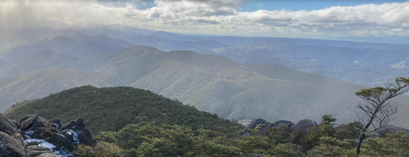
Once on the crest of the range, follow the well-worn route southward. The route undulates along the range through interesting granite rock formations. The elevation is below the natural tree line, but the patchy sub-alpine scrub allows good views across both sides of the range. The geographic summit of Conical Hill is located just into the beginning of a broad treeless expanse, and is marked by a metal pipe in a granite outcrop.
For day trips, you will need to return the way you came. Lookout Range Route continues south along Hope Range, before dropping into the head of the Dart River and climbing Lookout Range on the other side. Granity Pass Hut is approx. 11 km from the summit of Conical Hill and involves over 8 km of travel along the open tops. It is therefore very hazardous in poor weather conditions.
The top of Hope Range is an alpine environment, so proper preparation and care should be made to ensure a safe trip. The route reaches a high elevation and is exposed above the tree line, so proper outdoor clothing is essential. You must always be prepared for freezing conditions and take extreme care if snow and ice and are present. Do not rely on the Nelson weather forecast as the alpine weather conditions in Kahurangi National Park are likely to be drastically different. Make sure you carry plenty of water with you as there are few water sources on the way up.
See the Mountain Safety Council website for useful information on preparing for the outdoors.
Conical Hill (1202 m) is at the northern end of the Hope Range, east of Mt Owen. It is accessed via Lookout Range Route, which climbs the range through interesting forest and granite rock formations, before continuing over Lookout Range to Granity Pass Hut.
| Details | |
| Length | 15.6 km return from Tadmor-Glenhope Rd |
| Time Required | 6 hr return from Tadmor-Glenhope Rd |
| Trail Type | Tramping track |
| Physical Difficulty | Moderate |
| Uses | Walking and trail running |
| Direction | Either |
| Dog Access | Dogs are prohibited in Kahurangi National Park |
1 hr 5 min from Nelson
The beginning of Lookout Range Route is a 70 km drive southwest of Nelson. Head south along SH6 to Kohatu and turn right onto Motueka Valley Highway. Continue to Tapawera, where you turn left onto Tadmor Valley Rd. Follow Tadmor Valley Rd for approx. 26 km. The route starts on the right side of the road, where you will see a DOC sign and a small parking bay.
Lookout Range Route begins by heading around private land and then crosses Tadmor River (impassable if running high). It then follows a forestry road to a skid site, where you’ll turn left and head through a block of douglas fir, before entering the native bush of Kahurangi National Park. The route, often rooty and muddy, steadily climbs up the eastern side of Hope Range. Initially the forest is mainly beech with a mix of rimu and other podocarps, though midway up you’ll notice numerous yellow-silver pine, which appear to thrive on the underlying granite geology. The bush gradually transitions to mountain beech as you gain elevation.
Once on the crest of the range, follow the well-worn route southward. The route undulates along the range through interesting granite rock formations. The elevation is below the natural tree line, but the patchy sub-alpine scrub allows good views across both sides of the range. The geographic summit of Conical Hill is located just into the beginning of a broad treeless expanse, and is marked by a metal pipe in a granite outcrop.
For day trips, you will need to return the way you came. Lookout Range Route continues south along Hope Range, before dropping into the head of the Dart River and climbing Lookout Range on the other side. Granity Pass Hut is approx. 11 km from the summit of Conical Hill and involves over 8 km of travel along the open tops. It is therefore very hazardous in poor weather conditions.
The top of Hope Range is an alpine environment, so proper preparation and care should be made to ensure a safe trip. The route reaches a high elevation and is exposed above the tree line, so proper outdoor clothing is essential. You must always be prepared for freezing conditions and take extreme care if snow and ice and are present. Do not rely on the Nelson weather forecast as the alpine weather conditions in Kahurangi National Park are likely to be drastically different. Make sure you carry plenty of water with you as there are few water sources on the way up.
See the Mountain Safety Council website for useful information on preparing for the outdoors.
Granity Pass Hut and Mt Owen (via Lookout Range)
Walking and trail running
Updated 26 July 2021