Scenic Reserve
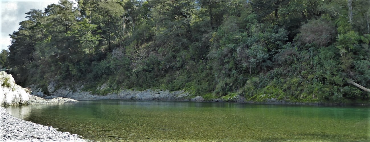
Pelorus Bridge is roughly halfway between Nelson and Blenheim. Though it is mostly known for the single-lane highway bridge that crosses the picturesque Te Hoiere / Pelorus River, the area is perhaps less-known as being one of the last remaining stands of lowland podocarp forest in Marlborough. Pelorus Bridge Scenic Reserve encompasses the remaining forest, through which there are several easy-grade short walks beginning directly from the highway.
If any layers fail to load, try clearing your cache and refreshing the page.
Dalton’s Track (Te Araroa Trail)
Walking, trail running and MTB
Maungatapu Road (Te Araroa Trail)
Walking, trail running and MTB
Trig K Circuit
Walking and trail running
45 min from Nelson | 40 min from Blenheim
Pelorus Bridge is a 45 min drive along State Highway 6 from Nelson, via Whangamoa and Rai saddles. From Blenheim, it is a 40 min drive, also along State Highway 6.
Pelorus Bridge has parking on either side of the highway, as well as toilets and a cafe. There are useful DOC maps and information panels detailing the ecology and history of the area. All tracks are well-signposted.
| Length | 1.9 km | Time Required | 45 min |
| Uses | Walking | Physical Difficulty | Easy |
Circle Loop Track starts immediately on the other side of the state highway bridge from Kānuka car park. The smooth, wheelchair-friendly track follows the river to a suspension bridge across Rai River, just upstream of its confluence with Pelorus River. On the eastern bank the track is a bit rougher, with roots and steps. The track makes a loop back to the bridge, passing through forest featuring tawa, rimu, beech and kahikatea. On the far side of the loop Dalton’s Track (Te Araroa Trail) continues down Pelorus Valley to Daltons Bridge, two kilometres from Canvastown. As Circle Loop Track is high above the river, there are no access points down to it.
| Length | 4.3 km return from car park | Time Required | 1 hr 15 min |
| Uses | Walking | Physical Difficulty | Easy |
The walk to Elvy Stream Waterfall is the longest of the short and easy walks at Pelorus Bridge. The waterfall is located partway along the lower half of Trig K Circuit and is accessed via Tawa Walk. After leaving Tawa Walk, the track follows the true right of Pelorus River through native bush to a small waterfall on Elvy Stream, a tributary of Pelorus River. Return the way you came, or if you have time, continue up the Trig K Circuit.
| Length | 900 m | Time Required | 20 min |
| Uses | Walking | Physical Difficulty | Very easy |
Tawa Walk is a short loop track beginning and ending at the car park on the cafe side of the highway. The wheelchair-friendly track passes through beautiful podocarp forest featuring some of the most magnificent rimu and kahikatea specimens you will ever see, with some reaching over 40 m in height. The far end of the track is where Trig K Circuit begins and Elvy Stream Waterfall is accessed.
| Length | 650 m | Time Required | 15 min |
| Uses | Walking | Physical Difficulty | Very easy |
Totara Walk is a short loop track that begins and ends at Kānuka car park (eastbound side of highway). The wheelchair-friendly track passes through some impressive totara, rimu and kahikatea. A short side track leads to Totara Flat Picnic Area, which overlooks a bend in the Pelorus River. Another side track leads down to the banks of the river, where there is a good swimming hole.


Pelorus Bridge is roughly halfway between Nelson and Blenheim. Though it is mostly known for the single-lane highway bridge that crosses the picturesque Te Hoiere / Pelorus River, the area is perhaps less-known as being one of the last remaining stands of lowland podocarp forest in Marlborough. Pelorus Bridge Scenic Reserve encompasses the remaining forest, through which there are several easy-grade short walks beginning directly from the highway.
45 min from Nelson | 40 min from Blenheim
Pelorus Bridge is a 45 min drive along State Highway 6 from Nelson, via Whangamoa and Rai saddles. From Blenheim, it is a 40 min drive, also along State Highway 6.
Pelorus Bridge has parking on either side of the highway, as well as toilets and a cafe. There are useful DOC maps and information panels detailing the ecology and history of the area. All tracks are well-signposted.
| Length | 1.9 km |
| Time Required | 45 min |
| Uses | Walking |
| Physical Difficulty | Easy |
Circle Loop Track starts immediately on the other side of the state highway bridge from Kānuka car park. The smooth, wheelchair-friendly track follows the river to a suspension bridge across Rai River, just upstream of its confluence with Pelorus River. On the eastern bank the track is a bit rougher, with roots and steps. The track makes a loop back to the bridge, passing through forest featuring tawa, rimu, beech and kahikatea. On the far side of the loop Dalton’s Track (Te Araroa Trail) continues down Pelorus Valley to Daltons Bridge, two kilometres from Canvastown. As Circle Loop Track is high above the river, there are no access points down to it.
| Length | 4.3 km return to car park |
| Time Required | 1 hr 15 min |
| Uses | Walking |
| Physical Difficulty | Easy |
The walk to Elvy Stream Waterfall is the longest of the short and easy walks at Pelorus Bridge. The waterfall is located partway along the lower half of Trig K Circuit and is accessed via Tawa Walk. After leaving Tawa Walk, the track follows the true right of Pelorus River through native bush to a small waterfall on Elvy Stream, a tributary of Pelorus River. Return the way you came, or if you have time, continue up the Trig K Circuit.
| Length | 900 m |
| Time Required | 20 min |
| Uses | Walking |
| Physical Difficulty | Very easy |
Tawa Walk is a short loop track beginning and ending at the car park on the cafe side of the highway. The wheelchair-friendly track passes through beautiful podocarp forest featuring some of the most magnificent rimu and kahikatea specimens you will ever see, with some reaching over 40 m in height. The far end of the track is where Trig K Circuit begins and Elvy Stream Waterfall is accessed.
| Length | 650 m |
| Time Required | 15 min |
| Uses | Walking |
| Physical Difficulty | Very easy |
Totara Walk is a short loop track that begins and ends at Kānuka car park (eastbound side of highway). The wheelchair-friendly track passes through some impressive totara, rimu and kahikatea. A short side track leads to Totara Flat Picnic Area, which overlooks a bend in the Pelorus River. Another side track leads down to the banks of the river, where there is a good swimming hole.
Dalton’s Track (Te Araroa Trail)
Walking, trail running and MTB
Maungatapu Road (Te Araroa Trail)
Walking, trail running and MTB
Trig K Circuit
Walking and trail running
Updated 26 August 2020