Lake Sylvester is situated in an alpine basin, above Cobb Reservoir in Kahurangi National Park. It’s a good option as an easy overnight tramp, staying at Sylvester Hut, and provides access for further exploration of the surrounding alpine environment, including Iron Hill and Diamond Lake.
| Details | |
| Distances | 5.4 km to Sylvester Hut; 1.1 km Sylvester Hut to Lake Sylvester; 8 km return Sylvester Hut to Iron Hill |
| Time Required | 2 hr to Sylvester Hut; 15 min Sylvester Hut to Lake Sylvester; 3 hr return Sylvester Hut to Iron Hill |
| Trail Type | 4WD road/Tramping track |
| Physical Difficulty | Moderate |
| Uses | Walking and trail running |
| Direction | Return (up and down) |
| Start Elevation | 850 m |
| Finish Elevation | 1320 m (Sylvester Hut) |
| Dog Access | Dogs are prohibited in Kahurangi National Park |
If any layers fail to load, try clearing your cache and refreshing the page.
This elevation profile should be considered approximate. Its accuracy is determined by the quality of data available.
Lake Sylvester Track does not connect to any other official tracks. Several unmaintained routes continue above Lake Sylvester, to Iron Lake, Iron Hill and Diamond Lake. Experienced parties can traverse the range northwest from Iron Hill, to connect with Waingaro Peak Track above Fenella Hut, at the head of Cobb Valley.
2 hr from Nelson | 1 hr from Takaka
From Richmond, head west along State Highway 60. After you’ve driven over Takaka Hill, turn left at Upper Takaka onto Cobb Dam Road, and follow it up Cobb Valley and over the ridge to Cobb Reservoir. The road is very narrow and has steep drop-offs to Takaka River below, so you must drive with caution. The road is unsealed from the turbine house, and reaches 1100 m elevation at Cobb Ridge, meaning snow and ice can be present throughout the year.
When you reach the reservoir edge, turn right at the junction and follow the road across the dam crest. The road leads to a small parking area, where there is a small structure holding an intentions book.
The 4WD road, constructed in the 1940s as part of the Cobb Hydro scheme, sidles the hillside through grass and scrub for 1.3 km. It then enters beech forest and climbs up the valley side through a series of zig-zags. The gradient is reasonably consistent and does not get too steep.
At 1250 m elevation the forest thins and opens up to a mix of tussock and mountain beech. Openings in the trees allow views northwest toward Lockett Range.
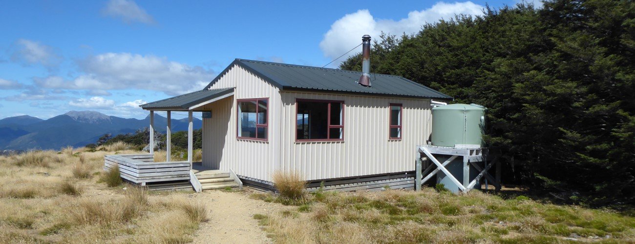
Sylvester Hut is well-positioned against the forest edge, with open tussock to the north and east allowing good views toward the western side of Arthur Range. The current hut was constructed in 2003, replacing the old Bushline Hut, which was located in a less than favourable position closer to Lake Sylvester.
| Sylvester Hut | |
| Hut Type | Serviced Hut |
| Capacity | 12 bunks |
| Bookings | Not required; first in, first served |
| Fee | 1 Serviced Hut Ticket |
| Facilities | Woodburner, mattresses, plenty of space for tents outside |
| Altitude | 1320 m |
A track continues from the hut toward Lake Sylvester, about 1 km away. The lake level was artificially raised to increase storage capacity of the Cobb Hydro scheme, though this only lasted a short time. The interesting history of this enterprise is detailed in Gerard Hindmarsh’s Kahurangi Calling.
The track continues around Lake Sylvester to an artificial connection with Little Sylvester Lake. The official track ends here, and a cairn-marked route continues up a hummocky, boulder-strewn moraine deposit to Iron Lake, which is situated in a cirque beneath the impressive crags of Iron Hill.
The cairn-marked route continues up Iron Hill from the northern end of Iron Lake. From below, the rocky slope looks inaccessible, though the climb is relatively straight-forward. The summit (1695 m) provides stunning views of the interior Kahurangi National Park.
From here it is possible to traverse the entire range to connect with Waingaro Peak Track above Fenella Hut, though this requires a day-long window of clear weather. You can also drop down to Diamond Lake, which is known for its beautiful campsites.
Lake Sylvester is an alpine environment, so proper preparation and care should be made to ensure a safe trip. The track reaches a high elevation and is exposed above the tree line, so proper outdoor clothing is essential. Be sure to check the alpine weather forecast for Kahurangi National Park before you go. You must always be prepared for freezing conditions and take extreme care if snow and ice and are present, particularly if you are climbing Iron Hill.
See the Mountain Safety Council website for useful information on preparing for the outdoors.


Lake Sylvester is situated in an alpine basin, above Cobb Reservoir in Kahurangi National Park. It’s a good option as an easy overnight tramp, staying at Sylvester Hut, and provides access for further exploration of the surrounding alpine environment, including Iron Hill and Diamond Lake.
| Details | |
| Distances | 5.4 km to Sylvester Hut; 1.1 km Sylvester Hut to Lake Sylvester; 8 km return Sylvester Hut to Iron Hill |
| Time Required | 2 hr to Sylvester Hut; 15 min Sylvester Hut to Lake Sylvester; 3 hr return Sylvester Hut to Iron Hill |
| Trail Type | 4WD road/Tramping track |
| Physical Difficulty | Moderate |
| Uses | Walking and trail running |
| Direction | Return (up and down) |
| Start Elevation | 850 m |
| Finish Elevation | 1320 m (Sylvester Hut) |
| Dog Access | Dogs are prohibited in Kahurangi National Park |
2 hr from Nelson | 1 hr from Takaka
From Richmond, head west along State Highway 60. After you’ve driven over Takaka Hill, turn left at Upper Takaka onto Cobb Dam Road, and follow it up Cobb Valley and over the ridge to Cobb Reservoir. The road is very narrow and has steep drop-offs to Takaka River below, so you must drive with caution. The road is unsealed from the turbine house, and reaches 1100 m elevation at Cobb Ridge, meaning snow and ice can be present throughout the year.
When you reach the reservoir edge, turn right at the junction and follow the road across the dam crest. The road leads to a small parking area, where there is a small structure holding an intentions book.
The 4WD road, constructed in the 1940s as part of the Cobb Hydro scheme, sidles the hillside through grass and scrub for 1.3 km. It then enters beech forest and climbs up the valley side through a series of zig-zags. The gradient is reasonably consistent and does not get too steep.
At 1250 m elevation the forest thins and opens up to a mix of tussock and mountain beech. Openings in the trees allow views northwest toward Lockett Range.
Sylvester Hut is well-positioned against the forest edge, with open tussock to the north and east allowing good views toward the western side of Arthur Range. The current hut was constructed in 2003, replacing the old Bushline Hut, which was located in a less than favourable position closer to Lake Sylvester.
| Sylvester Hut | |
| Hut Type | Serviced Hut |
| Capacity | 12 bunks |
| Bookings | Not required; first in, first served |
| Fee | 1 Serviced Hut Ticket |
| Facilities | Woodburner, mattresses, plenty of space for tents outside |
| Altitude | 1320 m |
A track continues from the hut toward Lake Sylvester, about 1 km away. The lake level was artificially raised to increase storage capacity of the Cobb Hydro scheme, though this only lasted a short time. The interesting history of this enterprise is detailed in Gerard Hindmarsh’s Kahurangi Calling.
The track continues around Lake Sylvester to an artificial connection with Little Sylvester Lake. The official track ends here, and a cairn-marked route continues up a hummocky, boulder-strewn moraine deposit to Iron Lake, which is situated in a cirque beneath the impressive crags of Iron Hill.
The cairn-marked route continues up Iron Hill from the northern end of Iron Lake. From below, the rocky slope looks inaccessible, though the climb is relatively straight-forward. The summit (1695 m) provides stunning views of the interior Kahurangi National Park.
From here it is possible to traverse the entire range to connect with Waingaro Peak Track above Fenella Hut, though this requires a day-long window of clear weather. You can also drop down to Diamond Lake, which is known for its beautiful campsites.
Lake Sylvester is an alpine environment, so proper preparation and care should be made to ensure a safe trip. The track reaches a high elevation and is exposed above the tree line, so proper outdoor clothing is essential. Be sure to check the alpine weather forecast for Kahurangi National Park before you go. You must always be prepared for freezing conditions and take extreme care if snow and ice and are present, particularly if you are climbing Iron Hill.
See the Mountain Safety Council website for useful information on preparing for the outdoors.
Lake Sylvester Track does not connect to any other official tracks. Several unmaintained routes continue above Lake Sylvester, to Iron Lake, Iron Hill and Diamond Lake. Experienced parties can traverse the range northwest from Iron Hill, to connect with Waingaro Peak Track above Fenella Hut, at the head of Cobb Valley.