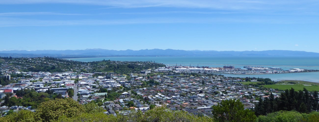
The ‘Centre of New Zealand’ is located atop Botanical Hill (147 m), on the eastern edge of Nelson city centre. A network of tracks thread through the reserve encompassing the hill, with connections to Sir Stanley Whitehead Park and Branford Park in the Maitai Valley. The summit offers views over central Nelson and Tasman Bay.
| Details | |
| Length | 2 km return (shortest route) |
| Time Required | Allow at least 30 min |
| Trail Type | Walking track |
| Physical Difficulty | Easy |
| Uses | Walking and running |
| Start Elevation | 5 m |
| Max Elevation | 147 m |
If any layers fail to load, try clearing your cache and refreshing the page.
This elevation profile should be considered approximate. Its accuracy is determined by the quality of data available.

5 min from anywhere in central Nelson
Botanical Hill is immediately east of the city centre. The main access points are Botanic Sports Field and Branford Park. There is plenty of parking around the edge of Botanic Sports Field, on both Milton Street and Hardy Street East. To access the hill from Maitai Valley, there are two car parks in Branford Park. There is a public toilet and drinking fountain on the city side of Botanic Sport Field, and a toilet in Branford Park at the Black Hole car park.
There are multiple ways to reach the summit as there are many links between the tracks (see map). Most tracks are wide and well-graded, with signposts giving good directions. The main track to the summit begins at the base of Botanical Hill on the far side of Botanics Sports Field (the site of New Zealand’s first ever rugby game in 1870) and zig-zags up the western aspect of the hill for 1 km to the summit. Follow the signposts on the way up to stay on the main track.
The hillside is forested in a mixture of exotic and regenerating native vegetation, which provides pleasant shade on warm days. Native species replanted on the hillside include totara, rimu and a solitary kauri (planted in 1951). You may notice the predator traps off the side of the track, which are helping to increase the numbers of native bird species like bellbird and kereru.
Near the top of the hill there is a junction where two tracks split off the main track; one heads north into Sir Stanley Whitehead Park (linking to Walter’s Bluff) and the other heads east, dropping down to Branford Park (via East Ridge Track). The remainder of the loop track around the summit is sealed.
At the summit a monument (built in 1968) marks the surveyed trig point and a lookout platform hosts information panels and seating. Enjoy the great views over the central city, Tasman Bay, and inland up the Maitai Valley.
On the return leg you can head back the way you came, or use one of the several other tracks. For a longer loop, descend East Ridge Track to Branford Park, and follow Maitai River Walkway downstream to the Hardy Street pedestrian bridge to return to where you started.
Note that Botanical Hill is not the actual ‘centre’ of New Zealand. Given its prominence and location next to the city centre, the top of the hill was used as an starting point for trigonometrical surveys by Chief Surveyor of Nelson, John Spence Browning in the 1870s. The true geographical centre of New Zealand (by one of several methods) is in Golden Downs Forest, a few kilometres south of Kohatu.


The ‘Centre of New Zealand’ is located atop Botanical Hill (147 m), on the eastern edge of Nelson city centre. A network of tracks thread through the reserve encompassing the hill, with connections to Sir Stanley Whitehead Park and Branford Park in the Maitai Valley. The summit offers views over central Nelson and Tasman Bay.
| Details | |
| Length | 2 km return (shortest route) |
| Time Required | Allow at least 30 min |
| Trail Type | Walking track |
| Physical Difficulty | Easy |
| Uses | Walking and running |
| Start Elevation | 5 m |
| Max Elevation | 147 m |
This elevation profile should be considered approximate. Its accuracy is determined by the quality of data available.
5 min from anywhere in central Nelson
Botanical Hill is immediately east of the city centre. The main access points are Botanic Sports Field and Branford Park. There is plenty of parking around the edge of Botanic Sports Field, on both Milton Street and Hardy Street East. To access the hill from Maitai Valley, there are two car parks in Branford Park. There is a public toilet and drinking fountain on the city side of Botanic Sport Field, and a toilet in Branford Park at the Black Hole car park.
There are multiple ways to reach the summit as there are many links between the tracks (see map). Most tracks are wide and well-graded, with signposts giving good directions. The main track to the summit begins at the base of Botanical Hill on the far side of Botanics Sports Field (the site of New Zealand’s first ever rugby game in 1870) and zig-zags up the western aspect of the hill for 1 km to the summit. Follow the signposts on the way up to stay on the main track.
The hillside is forested in a mixture of exotic and regenerating native vegetation, which provides pleasant shade on warm days. Native species replanted on the hillside include totara, rimu and a solitary kauri (planted in 1951). You may notice the predator traps off the side of the track, which are helping to increase the numbers of native bird species like bellbird and kereru.
Near the top of the hill there is a junction where two tracks split off the main track; one heads north into Sir Stanley Whitehead Park (linking to Walter’s Bluff) and the other heads east, dropping down to Branford Park (via East Ridge Track). The remainder of the loop track around the summit is sealed.
At the summit a monument (built in 1968) marks the surveyed trig point and a lookout platform hosts information panels and seating. Enjoy the great views over the central city, Tasman Bay, and inland up the Maitai Valley.
On the return leg you can head back the way you came, or use one of the several other tracks. For a longer loop, descend East Ridge Track to Branford Park, and follow Maitai River Walkway downstream to the Hardy Street pedestrian bridge to return to where you started.
Note that Botanical Hill is not the actual ‘centre’ of New Zealand. Given its prominence and location next to the city centre, the top of the hill was used as an starting point for trigonometrical surveys by Chief Surveyor of Nelson, John Spence Browning in the 1870s. The true geographical centre of New Zealand (by one of several methods) is in Golden Downs Forest, a few kilometres south of Kohatu.
Updated 18 February 2019