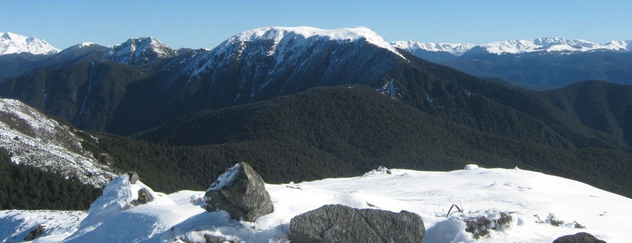
Pukeone / Mt Campbell (1330 m) is a peak at the northern end of Arthur Range, west of Motueka. It is recognisable for having a transmission tower at its summit, a return trip to which offers a half-day walk with spectacular views. Note that permission should be gained from the land owner to access the summit.
| Details | |
| Length | 9.2 km return (from locked gate) |
| Time Required | 3-4 hr return (from locked gate) |
| Trail Type | 4WD road |
| Physical Difficulty | Moderate |
| Uses | Walking, trail running and MTB |
| Start Elevation | 35 m (start of Rocky River Rd) or 780 m (locked gate) |
| Max Elevation | 1330 m |
| Dog Access | Consult the land owner. Dogs are prohibited within Kahurangi National Park boundary |
If any layers fail to load, try clearing your cache and refreshing the page.
Mt Campbell Road does not connect to any other official tracks. Highly experienced parties may continue along Arthur Range to Hoary Head, Crusader and Lodestone.
1 hr from Nelson
Mt Campbell Road begins at the locked gate at the end of Rocky River Road, which is accessed off Motueka River West Bank Road, 57 km from Nelson. Rocky River Road is unsealed and crosses several small fords, but most vehicles should be able to handle it until the sign that reads “Steep Grade 4WD Access only”. Leave 2WD and vehicles without a low-range-gearbox and high-ground clearance at this sign. The locked access gate is approximately 1.2 km beyond this sign and 9.7 km up Rocky River Road. Note that the land beyond the gate, including the northern half of Mt Campbell, is private property. The gate has a phone number on it that you can call to ask the land owner for permission to cross their land.
From the gate, the road climbs steadily, and sometimes steeply, up the hillside through scrub and patches of beech forest. At 1150 m elevation the sub-alpine scrub opens up to tussock, and the road zig-zags upward. The road surface here is deep, coarse gravel, which will likely force you to walk your bike in places. At the top there is a picnic table next to the transmission tower. The prominence of Mt Campbell allows amazing views east across Tasman Bay, north into Golden Bay and west toward the Tasman Mountains.
Return the way you came.
Mt Campbell is an alpine environment and is highly-exposed, so proper preparation and care is essential ensure a safe trip. The track reaches a high elevation and is exposed above the treeline, so proper outdoor clothing is essential. You must always be prepared for freezing conditions and take extreme care if snow and ice and are present. Be sure to check the forecast for Kahurangi National Park; do not rely on the Nelson or Motueka weather forecasts as the alpine conditions are likely to be drastically different. There are no water sources along the way so bring plenty of water with you.
See the Mountain Safety Council website for useful information on preparing for the outdoors.
Pukeone / Mt Campbell (1330 m) is a peak at the northern end of Arthur Range, west of Motueka. It is recognisable for having a transmission tower at its summit, a return trip to which offers a half-day walk with spectacular views. Note that permission should be gained from the land owner to access the summit.
| Details | |
| Length | 9.2 km return (from locked gate) |
| Time Required | 3-4 hr return (from locked gate) |
| Trail Type | 4WD road |
| Physical Difficulty | Moderate |
| Uses | Walking, trail running and MTB |
| Start Elevation | 35 m (start of Rocky River Rd) or 780 m (locked gate) |
| Max Elevation | 1330 m |
| Dog Access | Consult the land owner. Dogs are prohibited within Kahurangi National Park boundary |
1 hr from Nelson
Mt Campbell Road begins at the locked gate at the end of Rocky River Road, which is accessed off Motueka River West Bank Road, 57 km from Nelson. Rocky River Road is unsealed and crosses several small fords, but most vehicles should be able to handle it until the sign that reads “Steep Grade 4WD Access only”. Leave 2WD and vehicles without a low-range-gearbox and high-ground clearance at this sign. The locked access gate is approximately 1.2 km beyond this sign and 9.7 km up Rocky River Road. Note that the land beyond the gate, including the northern half of Mt Campbell, is private property. The gate has a phone number on it that you can call to ask the land owner for permission to cross their land.
From the gate, the road climbs steadily, and sometimes steeply, up the hillside through scrub and patches of beech forest. At 1150 m elevation the sub-alpine scrub opens up to tussock, and the road zig-zags upward. The road surface here is deep, coarse gravel, which will likely force you to walk your bike in places. At the top there is a picnic table next to the transmission tower. The prominence of Mt Campbell allows amazing views east across Tasman Bay, north into Golden Bay and west toward the Tasman Mountains.
Return the way you came.
Mt Campbell is an alpine environment and is highly-exposed, so proper preparation and care is essential ensure a safe trip. The track reaches a high elevation and is exposed above the treeline, so proper outdoor clothing is essential. You must always be prepared for freezing conditions and take extreme care if snow and ice and are present. Be sure to check the forecast for Kahurangi National Park; do not rely on the Nelson or Motueka weather forecasts as the alpine conditions are likely to be drastically different. There are no water sources along the way so bring plenty of water with you.
See the Mountain Safety Council website for useful information on preparing for the outdoors.
Mt Campbell Road does not connect to any other official tracks. Highly experienced parties may continue along Arthur Range to Hoary Head, Crusader and Lodestone.
Updated 29 January 2019