Lees Creek Hut is a standard hut situated toward the headwaters of Lees Creek, on the western side of Raglan Range. The hut can be visited as a day walk, an easy overnight trip, or as part of expeditions traversing the surrounding peaks and valleys of the Rainbow and Leatham conservation areas.
| Details | |
| Length | 9 km one way to hut from Rainbow Road |
| Time Required | 3-4 hr one way to hut from Rainbow Road |
| Trail Type | Tramping track |
| Physical Difficulty | Moderate |
| Uses | Walking and trail running |
| Direction | Either |
| Start Elevation | 720 m |
| Finish Elevation | 1010 m |
If any layers fail to load, try clearing your cache and refreshing the page.
Lees Creek Track does not connect to any other official tracks.
1 hr 30 min from Nelson | 1 hr 45 min from Blenheim
The start of Lees Creek Track is located on Rainbow Road, approx. 22 km from the SH63 turnoff and 5 km past Six Mile Creek ford (Rainbow Ski Field turnoff). Note that Rainbow Road is only open to the public from Christmas to Easter; outside of this time a locked gate at Six Mile Creek prevents public vehicle access, which means you will have to walk from the locked gate to the start of the track start (adding 5 km each way). During summer when the road is open, you can continue to the track start, where there is a parking area. Note that crossing Six Mile Creek ford requires a high-clearance 4WD vehicle. Check with DOC to find out the status of the road.
The track begins at a swing bridge across the powerfully-flowing Wairau River, and climbs up a steep set of stairs next to a large boulder on the far side. The track heads along a terrace above the true right of the Wairau for a short distance, before turning east and following the true right of Lees Creek. A smaller swing bridge crosses to the true left of Lees Creek, and follows the latter up the valley through mountain beech. For the most part the track is fairly smooth, without too many particularly rocky or rooty sections. It climbs at gentle rate, with only a few short, steep sections to deal with. There is only one significant unbridged side creek to cross, which will likely be impassable following heavy rain. After 5 km you’ll cross the toe of a large scree slope extending all the way from the top of the Mangerton Ridge to the right, and soon after you’ll emerge onto the first of several meadows that encompass the valley floor. In these sections there are no markers or poles to mark the track, though a fairly well-worn path through the grass indicates the way. In the last kilometre before the hut the track climbs up an ancient moraine, where the creek tumbles down among large boulders.
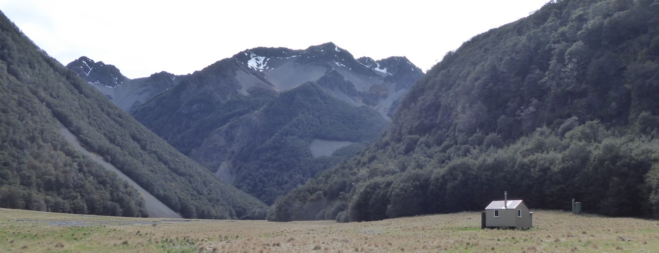
Lees Creek Hut is positioned on the southern side of the valley. The valley floor above the hut is a park-like meadow, allowing open views towards the crumbly peaks of Raglan Range towering to the east. The hut was originally located next to Sandfly Stream near the latter’s confluence with the Wairau River (approx. 13 km to the north), but was shifted to its present location in 1993. It was renovated in early 2021.
| Lees Creek Hut | |
| Hut Type | Standard Hut |
| Capacity | 4 |
| Bookings | Not required; first in, first served |
| Fee | 1 Standard Hut Ticket |
| Altitude | 1010 m |
There are no official tracks continuing beyond the hut, though experienced parties can venture further up the headwaters on day trips. It is possible to traverse into the Branch, Judges and Coldwater catchments, though this requires good navigation skills and experience negotiating steep, highly-eroded alpine terrain.


Lees Creek Hut is a standard hut situated toward the headwaters of Lees Creek, on the western side of Raglan Range. The hut can be visited as a day walk, an easy overnight trip, or as part of expeditions traversing the surrounding peaks and valleys of the Rainbow and Leatham conservation areas.
| Details | |
| Length | 9 km one way to hut from Rainbow Road |
| Time Required | 3-4 hr one way to hut from Rainbow Road |
| Trail Type | Tramping track |
| Physical Difficulty | Moderate |
| Uses | Walking and trail running |
| Direction | Either |
| Start Elevation | 720 m |
| Finish Elevation | 1010 m |
1 hr 30 min from Nelson | 1 hr 45 min from Blenheim
The start of Lees Creek Track is located on Rainbow Road, approx. 22 km from the SH63 turnoff and 5 km past Six Mile Creek ford (Rainbow Ski Field turnoff). Note that Rainbow Road is only open to the public from Christmas to Easter; outside of this time a locked gate at Six Mile Creek prevents public vehicle access, which means you will have to walk from the locked gate to the start of the track start (adding 5 km each way). During summer when the road is open, you can continue to the track start, where there is a parking area. Note that crossing Six Mile Creek ford requires a high-clearance 4WD vehicle. Check with DOC to find out the status of the road.
The track begins at a swing bridge across the powerfully-flowing Wairau River, and climbs up a steep set of stairs next to a large boulder on the far side. The track heads along a terrace above the true right of the Wairau for a short distance, before turning east and following the true right of Lees Creek. A smaller swing bridge crosses to the true left of Lees Creek, and follows the latter up the valley through mountain beech. For the most part the track is fairly smooth, without too many particularly rocky or rooty sections. It climbs at gentle rate, with only a few short, steep sections to deal with. There is only one significant unbridged side creek to cross, which will likely be impassable following heavy rain. After 5 km you’ll cross the toe of a large scree slope extending all the way from the top of the Mangerton Ridge to the right, and soon after you’ll emerge onto the first of several meadows that encompass the valley floor. In these sections there are no markers or poles to mark the track, though a fairly well-worn path through the grass indicates the way. In the last kilometre before the hut the track climbs up an ancient moraine, where the creek tumbles down among large boulders.
Lees Creek Hut is positioned on the southern side of the valley. The valley floor above the hut is a park-like meadow, allowing open views towards the crumbly peaks of Raglan Range towering to the east. The hut was originally located next to Sandfly Stream near the latter’s confluence with the Wairau River (approx. 13 km to the north), but was shifted to its present location in 1993. It was renovated in early 2021.
| Lees Creek Hut | |
| Hut Type | Standard Hut |
| Capacity | 4 |
| Bookings | Not required; first in, first served |
| Fee | 1 Standard Hut Ticket |
| Altitude | 1010 m |
There are no official tracks continuing beyond the hut, though experienced parties can venture further up the headwaters on day trips. It is possible to traverse into the Branch, Judges and Coldwater catchments, though this requires good navigation skills and experience negotiating steep, highly-eroded alpine terrain.
Lees Creek Track does not connect to any other official tracks.
Updated 10 November 2021