Lake Matiri Track gives access to Lake Matiri, a small lake formed by a landslide 300 years ago, in the Matiri Valley north of Murchison. Lake Matiri Hut sits above the lake and is an easy option for an overnight tramp. Lake Matiri Track gives access to Thousand Acre Plateau (Poor Pete’s Hut and Larrikin Creek Hut) and the upper Matiri Valley (McConchies Hut and Hurricane Hut).
| Details | |
| Length | 7 km road end to Lake Matiri Hut; 3 km road end to Matiri River West Branch crossing |
| Time Required | 3-4 hr one way to Lake Matiri Hut |
| Trail Type | Farm track/Tramping track |
| Physical Difficulty | Moderate |
| Uses | Walking and trail running |
| Direction | Either |
| Start Elevation | 240 m |
| Finish Elevation | 400 m (Lake Matiri Hut) |
| Dog Access | Dogs are prohibited in Kahurangi National Park |
If any layers fail to load, try clearing your cache and refreshing the page.
McConchies Hut (Matiri Valley Track)
Walking
Poor Pete’s Hut (1,000 Acres Plateau)
Walking
1 hr 45 min from Nelson | 25 min from Murchison
Turn onto Matiri Valley Road off State Highway 6, 106 km southwest of Nelson and 6 km north of Murchison. The track start is 16 km up Matiri Valley Road, the latter being unsealed for most of the distance up the valley. The road passes working farms so be careful of people and livestock. The road is suitable for 2WD vehicles though you will feel more comfortable in a 4WD.
Lake Matiri Track does not enter Kahurangi National Park; the national park boundary is just north of Lake Matiri, while the lake itself and the forest immediately south of it are protected in the Matiri Conservation Area.
No dogs or mountain bikes are permitted.
The track begins as a 4WD farm road, passing through pasture over river flats on the true right of the Matiri River. After 3 km the track reaches the granite riverbed of Matiri River West Branch. There is no bridge here so you will need to ford the river; this will be impossible if the river is running high. The 4WD road switches to a walking track on the other side of the river, and a few hundred metres along there is an emergency shelter intended for trampers returning to the road end who cannot continue due to the river being swollen.
Further upstream you will pass an old gate with a sign informing you that you’re entering Matiri Forest (now called Matiri Conservation Area), right before a bend in the river where the river has cut into the opposing bank, triggering a large landslide at some point in the past. You will need to boulder hop your away around the outside of the bend. Note that this section is impassable when the river is running high. The track enters mossy beech forest and climbs over the wide deposit of the landslide that was the cause of Lake Matiri’s formation. From here it is a short distance to the hut.
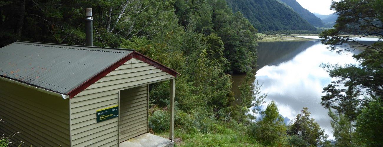
Lake Matiri Hut is perched on the western hillside above the lake. Trees have been cleared below the hut, allowing good views north across the lake and up Matiri Valley.
From the hut you can return the way you came. For longer trips, you can continue north along the lake edge and climb up to Thousand Acres Plateau (Matiri Range) and Poor Pete’s Hut, or continue on the valley floor to McConchies Hut.
| Lake Matiri Hut | |
| Hut Type | Standard Hut |
| Capacity | 8 bunks |
| Bookings | Not required; first in, first served |
| Fee | 1 Standard Hut Ticket |
| Altitude | 400 m |
Lake Matiri Track gives access to Lake Matiri, a small lake formed by a landslide 300 years ago, in the Matiri Valley north of Murchison. Lake Matiri Hut sits above the lake and is an easy option for an overnight tramp. Lake Matiri Track gives access to Thousand Acre Plateau (Poor Pete’s Hut and Larrikin Creek Hut) and the upper Matiri Valley (McConchies Hut and Hurricane Hut).
| Details | |
| Length | 7 km road end to Lake Matiri Hut; 3 km road end to Matiri River West Branch crossing |
| Time Required | 3-4 hr one way to Lake Matiri Hut |
| Trail Type | Farm track/Tramping track |
| Physical Difficulty | Moderate |
| Uses | Walking and trail running |
| Direction | Either |
| Start Elevation | 240 m |
| Finish Elevation | 400 m (Lake Matiri Hut) |
| Dog Access | Dogs are prohibited in Kahurangi National Park |
1 hr 45 min from Nelson | 25 min from Murchison
Turn onto Matiri Valley Road off State Highway 6, 106 km southwest of Nelson and 6 km north of Murchison. The track start is 16 km up Matiri Valley Road, the latter being unsealed for most of the distance up the valley. The road passes working farms so be careful of people and livestock. The road is suitable for 2WD vehicles though you will feel more comfortable in a 4WD.
Lake Matiri Track does not enter Kahurangi National Park; the national park boundary is just north of Lake Matiri, while the lake itself and the forest immediately south of it are protected in the Matiri Conservation Area.
No dogs or mountain bikes are permitted.
The track begins as a 4WD farm road, passing through pasture over river flats on the true right of the Matiri River. After 3 km the track reaches the granite riverbed of Matiri River West Branch. There is no bridge here so you will need to ford the river; this will be impossible if the river is running high. The 4WD road switches to a walking track on the other side of the river, and a few hundred metres along there is an emergency shelter intended for trampers returning to the road end who cannot continue due to the river being swollen.
Further upstream you will pass an old gate with a sign informing you that you’re entering Matiri Forest (now called Matiri Conservation Area), right before a bend in the river where the river has cut into the opposing bank, triggering a large landslide at some point in the past. You will need to boulder hop your away around the outside of the bend. Note that this section is impassable when the river is running high. The track enters mossy beech forest and climbs over the wide deposit of the landslide that was the cause of Lake Matiri’s formation. From here it is a short distance to the hut.
Lake Matiri Hut is perched on the western hillside above the lake. Trees have been cleared below the hut, allowing good views north across the lake and up Matiri Valley.
From the hut you can return the way you came. For longer trips, you can continue north along the lake edge and climb up to Thousand Acres Plateau (Matiri Range) and Poor Pete’s Hut, or continue on the valley floor to McConchies Hut.
| Lake Matiri Hut | |
| Hut Type | Standard Hut |
| Capacity | 8 bunks |
| Bookings | Not required; first in, first served |
| Fee | 1 Standard Hut Ticket |
| Altitude | 400 m |
McConchies Hut (Matiri Valley Track)
Walking
Poor Pete’s Hut (1,000 Acres Plateau)
Walking
Updated 18 February 2019