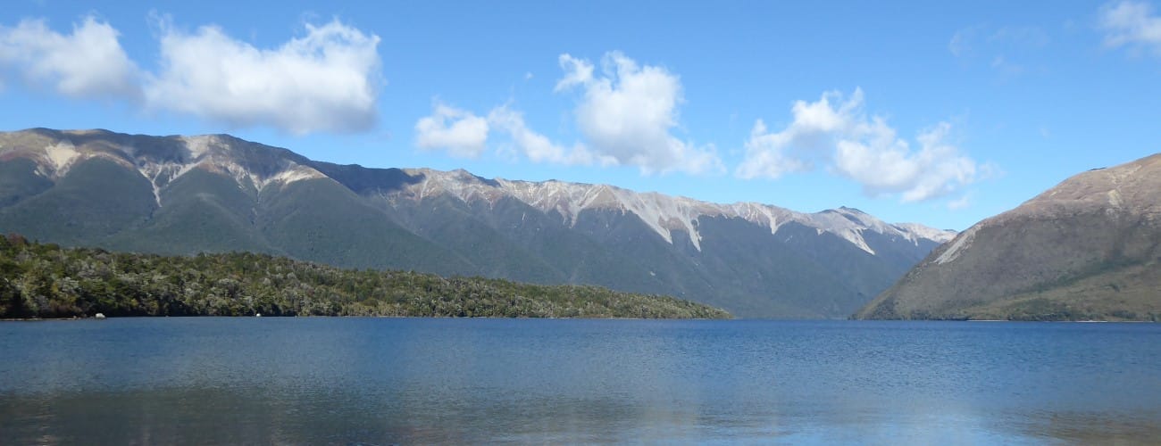
Lake Rotoiti Circuit is one of the easiest overnight tramps in Nelson Lakes National Park. The circuit circumnavigates Lake Rotoiti through beautiful beech forest, and being lakeside, offers plenty of places to swim in summer. This circuit is also great for trail running and is used annually for a popular trail running race.
| Details | |
| Length | 9.4 km Kerr Bay car park to Lakehead Hut; Lakehead Hut to Coldwater Hut 2 km via river crossing or 10 km via swingbridge; 10.1 km Coldwater Hut to West Bay car park; 3.8 km West Bay car park to Kerr Bay car park |
| Time Required | 3 hr Kerr Bay to Lakehead hut; 1-3 hr Lakehead Hut to Coldwater Hut; 3 hr 30 min Coldwater Hut to West Bay; 1 hr West Bay to Kerr Bay |
| Trail Type | Tramping track |
| Physical Difficulty | Moderate |
| Uses | Walking and trail running |
| Direction | Either |
| Dog Access | Dogs are prohibited in Nelson Lakes National Park |
If any layers fail to load, try clearing your cache and refreshing the page.
1 hr 5 min from Nelson | 1 hr 20 min from Blenheim
St Arnaud is the gateway to Lake Rotoiti and Nelson Lakes National Park, and is 75 km southwest of Nelson and 103 km west of Blenheim. Lakehead Track begins at the eastern end of Kerr Bay on Lake Rotoiti. There is plenty of parking at the lake edge and next to the DOC campground. You will see a large information board with a map, and times and distances of the various tracks in the area.
West Bay car park is a short drive from St Arnaud. Head west from St Arnaud for 2 min, and turn left onto Mt Robert Road. The car park is a short distance down the road, right next to the lake.
Nelson Lakes DOC Visitor Centre is located on View Road, St Arnaud. This is a good place to read up on the ecology, geology and history of St Arnaud and Nelson Lakes National Park, as well as check the latest alpine weather forecasts and speak to DOC staff about any warnings in place.
Beginning at the eastern end of Kerr Bay, Lakehead Track follows the eastern shore of Lake Rotoiti, never deviating very far from the lake edge. The track passes through forest dominated by red beech, though there are many other species like Hall’s tōtara, southern rata, pokaka and kamahi. The track undulates across the toes of spurs descending from the St Arnaud Range above, and in a couple of sections the track clambers over scree slopes that descend off the range and into the lake. A jetty is located shortly before the head of the lake is reached, and Lakehead Hut is about half a kilometre past it, in a slightly elevated position on the eastern edge of the Travers River plain.
| Lakehead Hut | |
| Hut Type | Serviced Hut |
| Capacity | 28 bunks |
| Bookings | Not required; first in, first served |
| Fee | 1 Serviced Hut Ticket |
| Altitude | 630 m |
The Travers River crossing route leads straight across the river flats from Lakehead Hut to connect with Lower Travers Valley Track just south of Coldwater Hut. When the river is low enough for a safe crossing, this is the much quicker way of getting across to Coldwater Hut (50 min). When the river is up, you will have to continue on Lakehead Track up the valley to a swing bridge, and return on the other side of the river along Lower Travers Valley Track (3 hr).
Coldwater Hut is located on the southern shore of the lake, next to where Travers River enters it. Being in the shadow of Robert Ridge, the hut has limited sunlight hours in winter and can be quite cold. A jetty outside the hut allows boat access.
| Coldwater Hut | |
| Hut Type | Standard Hut |
| Capacity | 12 bunks |
| Bookings | Not required; first in, first served |
| Fee | 1 Standard Hut Ticket |
| Altitude | 620 m |
Lakeside Track heads north from Coldwater Hut along the western side of the lake. You will reach Whisky Falls after 1 hr. Beyond here the forest transitions to thick regenerating kanuka and the track heads away from the lake edge and climbs gently over landslide deposits at the base of Mt Robert. Mt Robert Rd is reached 2 hr 30 min from Coldwater Hut. Follow the latter for 2.1 km to the main car park at West Bay. To return to Kerr Bay, continue along Brunner Peninsula Track which follows the lake edge. You can also cut a little bit off the distance by following the track that heads straight over the peninsula via the visitor centre.


Lake Rotoiti Circuit is one of the easiest overnight tramps in Nelson Lakes National Park. The circuit circumnavigates Lake Rotoiti through beautiful beech forest, and being lakeside, offers plenty of places to swim in summer. This circuit is also great for trail running and is used annually for a popular trail running race.
| Details | |
| Length | 9.4 km Kerr Bay car park to Lakehead Hut; Lakehead Hut to Coldwater Hut 2 km via river crossing or 10 km via swingbridge; 10.1 km Coldwater Hut to West Bay car park; 3.8 km West Bay car park to Kerr Bay car park |
| Time Required | 3 hr Kerr Bay to Lakehead hut; 1-3 hr Lakehead Hut to Coldwater Hut; 3 hr 30 min Coldwater Hut to West Bay; 1 hr West Bay to Kerr Bay |
| Trail Type | Tramping track |
| Physical Difficulty | Moderate |
| Uses | Walking and trail running |
| Direction | Either |
| Dog Access | Dogs are prohibited in Nelson Lakes National Park |
1 hr 5 min from Nelson | 1 hr 20 min from Blenheim
St Arnaud is the gateway to Lake Rotoiti and Nelson Lakes National Park, and is 75 km southwest of Nelson and 103 km west of Blenheim. Lakehead Track begins at the eastern end of Kerr Bay on Lake Rotoiti. There is plenty of parking at the lake edge and next to the DOC campground. You will see a large information board with a map, and times and distances of the various tracks in the area.
West Bay car park is a short drive from St Arnaud. Head west from St Arnaud for 2 min, and turn left onto Mt Robert Road. The car park is a short distance down the road, right next to the lake.
Nelson Lakes DOC Visitor Centre is located on View Road, St Arnaud. This is a good place to read up on the ecology, geology and history of St Arnaud and Nelson Lakes National Park, as well as check the latest alpine weather forecasts and speak to DOC staff about any warnings in place.
Beginning at the eastern end of Kerr Bay, Lakehead Track follows the eastern shore of Lake Rotoiti, never deviating very far from the lake edge. The track passes through forest dominated by red beech, though there are many other species like Hall’s tōtara, southern rata, pokaka and kamahi. The track undulates across the toes of spurs descending from the St Arnaud Range above, and in a couple of sections the track clambers over scree slopes that descend off the range and into the lake. A jetty is located shortly before the head of the lake is reached, and Lakehead Hut is about half a kilometre past it, in a slightly elevated position on the eastern edge of the Travers River plain.
| Lakehead Hut | |
| Hut Type | Serviced Hut |
| Capacity | 28 bunks |
| Bookings | Not required; first in, first served |
| Fee | 1 Serviced Hut Ticket |
| Altitude | 630 m |
The Travers River crossing route leads straight across the river flats from Lakehead Hut to connect with Lower Travers Valley Track just south of Coldwater Hut. When the river is low enough for a safe crossing, this is the much quicker way of getting across to Coldwater Hut (50 min). When the river is up, you will have to continue on Lakehead Track up the valley to a swing bridge, and return on the other side of the river along Lower Travers Valley Track (3 hr).
Coldwater Hut is located on the southern shore of the lake, next to where Travers River enters it. Being in the shadow of Robert Ridge, the hut has limited sunlight hours in winter and can be quite cold. A jetty outside the hut allows boat access.
| Coldwater Hut | |
| Hut Type | Standard Hut |
| Capacity | 12 bunks |
| Bookings | Not required; first in, first served |
| Fee | 1 Standard Hut Ticket |
| Altitude | 620 m |
Lakeside Track heads north from Coldwater Hut along the western side of the lake. You will reach Whisky Falls after 1 hr. Beyond here the forest transitions to thick regenerating kanuka and the track heads away from the lake edge and climbs gently over landslide deposits at the base of Mt Robert. Mt Robert Rd is reached 2 hr 30 min from Coldwater Hut. Follow the latter for 2.1 km to the main car park at West Bay. To return to Kerr Bay, continue along Brunner Peninsula Track which follows the lake edge. You can also cut a little bit off the distance by following the track that heads straight over the peninsula via the visitor centre.
Updated 26 March 2020