Fringed Hill (793 m) overlooks Brook Valley and central Nelson. Fringed Hill Road is a public forestry road that gives access to the hill summit and the challenging MTB tracks Black Diamond Ridge, FDH, Te Ara Koa and Butters. The climb to the summit is grueling, but well worth it for the views and downhill fun on offer.
| Details | |
| Length | 7.2 km from Tantragee car park to summit; 5.5 km from Tantragee Saddle to summit |
| Time Required | 2 hr to summit from Tantragee car park (walking) |
| Trail Type | Gravel road |
| Physical Difficulty | Hard |
| Technical Difficulty | Easy |
| Uses | Walking, trail running and MTB |
| Direction | Either |
| Start Elevation | 50 m |
| Max Elevation | 793 m |
If any layers fail to load, try clearing your cache and refreshing the page.
This elevation profile should be considered approximate. Its accuracy is determined by the quality of data available.
5 min from central Nelson
Fringed Hill Road begins at Tantragee Saddle and can be accessed from Brook Valley or Maitai Valley.
In Brook Valley there is a car park at the start of Tantragee Road, just across the bridge across The Brook. There is also street parking a kilometre further down the valley, at the start of Codgers Track. Both of these start points are only a 10-15 min ride from the city centre. If you intend to ride Te Ara Koa, Brook Valley is the best start point.
In the Maitai Valley, there are two car parks on each respective side of Maitai Motor Camp. Maitai River Walkway provides a good connection directly to the city centre, which is a 15-20 min ride. If you are using Fringed Hill to access Black Diamond Ridge and Sunrise Ridge, Maitai Valley is the best start point.
Logging and high fire risk will close access.
Follow Tantragee Road from either one of the car parks (in Brook Valley or Maitai Valley) to Tantragee Saddle, and at the top turn onto Fringed Hill Road, which continues uphill (you will see Nelson City Council signposts directing you).
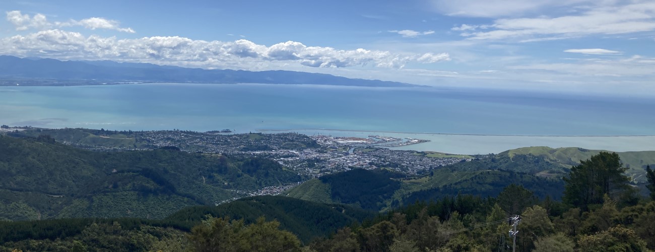
The road climbs in up and around Groom Creek gully, and then around the northern aspect of Fringed Hill, before switching back westward for the final climb. The average gradient of Fringed Hill Road is 11% and is reasonably consistent the whole way up. The hillside is covered in young pine trees which are low enough to allow amazing views north and west across Tasman Bay. The road rounds the upper slopes of Groom Creek gully again, before reaching the top of the unnamed spur that forms the western side of the gully. The road forks here.
To access the summit, turn left at the fork, (it is signposted) and continue up a couple more zig-zags. The summit hosts transmission masts and associated buildings, and there is a trig and a couple of wooden benches to relax on after your climb. Beech forest begins immediately behind the buildings, and a signs indicate the respective beginnings of Black Diamond Ridge (expert difficulty) and Te Ara Koa (advanced difficulty).
Instead of climbing to the summit, heading straight at the fork will take you to a clearing where Fringed Downhill (expert difficulty) descends down Bullock Spur into Brook Valley. Continue straight to head onto Fringed Hill Classic, which descends Cummins Spur through native bush and pine forest, and intersects Coppermine Trail at Four Corners.


Fringed Hill (793 m) overlooks Brook Valley and central Nelson. Fringed Hill Road is a public forestry road that gives access to the hill summit and the challenging MTB tracks Black Diamond Ridge, FDH, Te Ara Koa and Butters. The climb to the summit is grueling, but well worth it for the views and downhill fun on offer.
| Details | |
| Length | 7.2 km from Tantragee car park to summit; 5.5 km from Tantragee Saddle to summit |
| Time Required | 2 hr to summit from Tantragee car park (walking) |
| Trail Type | Gravel road |
| Physical Difficulty | Hard |
| Technical Difficulty | Easy |
| Uses | Walking, trail running and MTB |
| Direction | Either |
| Start Elevation | 50 m |
| Max Elevation | 793 m |
5 min from central Nelson
Fringed Hill Road begins at Tantragee Saddle and can be accessed from Brook Valley or Maitai Valley.
At Brook Valley there is a car park at the start of Tantragee Road, just across the bridge across The Brook. There is street parking a kilometre further down the valley, at the start of Codgers Track. Both of these start points are only a 10-15 min ride from the city centre. If you intend to ride Te Ara Koa, Brook Valley is the best start point.
In the Maitai Valley, there are two car parks on each respective side of Maitai Motor Camp. Maitai River Walkway provides a good connection directly to the city centre, which is a 15-20 min ride. If you are using Fringed Hill to access Black Diamond Ridge and Sunrise Ridge, Maitai Valley is the best start point.
Logging and high fire risk will close access.
Follow Tantragee Road from either one of the car parks (in Brook Valley or Maitai Valley) to Tantragee Saddle, and at the top turn onto Fringed Hill Road, which continues uphill (you will see Nelson City Council signposts directing you).
The road climbs in up and around Groom Creek gully, and then around the northern aspect of Fringed Hill, before switching back westward for the final climb. The average gradient of Fringed Hill Road is 11% and is reasonably consistent the whole way up. The hillside is covered in young pine trees which are low enough to allow amazing views north and west across Tasman Bay. The road rounds the upper slopes of Groom Creek gully again, before reaching the top of the unnamed spur that forms the western side of the gully. The road forks here.
To access the summit, turn left at the fork, (it is signposted) and continue up a couple more zig-zags. The summit hosts transmission masts and associated buildings, and there is a trig and a couple of wooden benches to relax on after your climb. Beech forest begins immediately behind the buildings, and a signs indicate the respective beginnings of Black Diamond Ridge (expert difficulty) and Te Ara Koa (advanced difficulty).
Instead of climbing to the summit, heading straight at the fork will take you to a clearing where Fringed Downhill (expert difficulty) descends down Bullock Spur into Brook Valley. Continue straight to head onto Fringed Hill Classic, which descends Cummins Spur through native bush and pine forest, and intersects Coppermine Trail at Four Corners.
Updated 18 February 2019