Champion Mine Circuit takes in the historic Champion Smelter, and Champion and United copper mines. The circuit provides insight to the history of Nelson’s short-lived copper industry that began in the late 1800s, and traverses the fascinating Dun Mountain Mineral Belt.
| Details | |
| Length | 13.3 km (full circuit) |
| Time Required | 4-5 hr (full circuit) |
| Trail Type | 4WD road/Tramping track |
| Physical Difficulty | Hard (full circuit) |
| Uses | Walking and trail running (MTB access to 4WD road end below United Mine) |
| Direction | Clockwise circuit direction recommended (United Mine to Champion Mine) |
| Start Elevation | 180 m |
| Max Elevation | 740 m |
| Dog Access | Dogs are prohibited in Roding Water Reserve |
If any layers fail to load, try clearing your cache and refreshing the page.
This circuit does not connect to any other official tracks. Experienced parties may climb Jenkins Hill via the historic Roding Ridge route, or continue onward from United Mine, to Monster Mine and Te Araroa Trail near Rocks Hut.
40 min from Nelson
Head south from Richmond along State Highway 6 and turn left onto Aniseed Valley Rd at Hope. Go over Aniseed Hill, and continue the entire way up Aniseed Valley Rd (15 km), until you reach the Roding car park. After the Hacket car park turnoff the last 7 km are unsealed. Roding car park is also the start point for trips up Mt Malita.
The track starts on the other side of Roding River; you must cross the river via the concrete ford as the swingbridge was washed away in Feb 2018. Make sure you fill out the intentions book, located at the information panel across the river from the car park.
Logging and high fire risk will close access.
Head past the caretaker’s house up the 4WD road that climbs above the true left of Roding River. Roding Dam is a short deviation off the left and is worthy of a look. The road descends and crosses Roding River, at which point it enters native forest. Soon you will see a sign indicating the turnoff to a shortcut track that cuts straight up the hill on the opposite side of the river to meet the tram alignment en route to Champion Mine. Continue along the road and cross Roding River next to where it forks with United Creek. Champion Smelter is a few hundred metres further along the road.
The remains of Champion Smelter are located on a grassy clearing at a bend on United Creek. An information panel describes the history of the mining operations, and photos provide an interesting perspective of what the site used to look like.
Continue along the road for a further 1.8 km until it ends at United Creek at the beginning of the mineral belt. Cross the creek and follow the track as it winds up a rocky gully through scrubby native bush to United Mine. The first evidence of mining operations are rusty artifacts that are scattered among the rocks and scrub. The gully opens up at the area of workings; at this point the track becomes a bit vague and quite difficult. Orange and white markers indicate the general direction, though the steep, loose ore deposits and boulders can be dangerous to traverse, especially as there is risk of dislodging rocks onto anyone following behind you. This section of the circuit is easier to climb than descend, and for this reason a clockwise circuit direction is recommended. There are several shafts driven into the hillside at varying levels up the gully. Beyond the signposted No.2 Level Shaft, the track climbs steeply out of the left side of the gully.
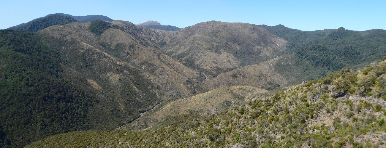
Once out of the gully and onto a spur, the track is well-defined and climbs steeply through the mineral belt to the top of the ridge that delineates the respective United Creek and Champion Creek catchments. A rocky knob marks the 739 m high point of the circuit. Here you will enjoy stunning views of the mineral belt. The track drops along the ridge and enters beech forest, zig-zagging down toward Champion Mine.
At the valley floor you will reach the junction with the tramway; turn left and you will immediately reach Champion Mine. The first thing you will see is the 46 m deep North Shaft. The shaft has been flooded since its abandonment a century ago, so it does not pose much danger. Across Champion Creek the tell-tale spoil piles indicate the location of Doctor’s Lode, the most profitable lode in the mined area. The South Shaft is on the true left of the creek and slightly further upstream; this shaft is dangerous as it is much wider than the North Shaft and is not flooded. Ore spoil piles drop steeply into the bed of Champion Creek, making it difficult to cross. Pieces of wood and some rusty relics lie scattered among the rocks and scrub.
The track back to the smelter follows the old tramway alignment, which means the gradient is gentle. In the century since its use, sections have slumped and vegetation has encroached, but the Roding caretaker does a good job to keep the track clear. You can turn left onto the aforementioned shortcut track that drops steeply down to the 4WD road, and head back to the car park. Otherwise continue along to the smelter and return along the 4WD road to the car park.
The mining areas contain abandoned shafts, none of which are fenced off and some are hidden by scrub. Spoil piles are difficult and dangerous to traverse, as the rock is loose and there is no vegetation to hold on to. The circuit has several river and stream crossings, so it cannot be done when flows are high.


Champion Mine Circuit takes in the historic Champion Smelter, and Champion and United copper mines. The circuit provides insight to the history of Nelson’s short-lived copper industry that began in the late 1800s, and traverses the fascinating Dun Mountain Mineral Belt.
| Details | |
| Length | 13.3 km (full circuit) |
| Time Required | 4-5 hr (full circuit) |
| Trail Type | 4WD road/Tramping track |
| Physical Difficulty | Hard (full circuit) |
| Uses | Walking and trail running (MTB access to 4WD road end below United Mine) |
| Direction | Clockwise circuit direction recommended (United Mine to Champion Mine) |
| Start Elevation | 180 m |
| Max Elevation | 740 m |
| Dog Access | Dogs are prohibited in Roding Water Reserve |
40 min from Nelson
Head south from Richmond along State Highway 6 and turn left onto Aniseed Valley Rd at Hope. Go over Aniseed Hill, and continue the entire way up Aniseed Valley Rd (15 km), until you reach the Roding car park. After the Hacket car park turnoff the last 7 km are unsealed. Roding car park is also the start point for trips up Mt Malita.
The track starts on the other side of Roding River; you must cross the river via the concrete ford as the swingbridge was washed away in Feb 2018. Make sure you fill out the intentions book, located at the information panel across the river from the car park.
Logging and high fire risk will close access.
Head past the caretaker’s house up the 4WD road that climbs above the true left of Roding River. Roding Dam is a short deviation off the left and is worthy of a look. The road descends and crosses Roding River, at which point it enters native forest. Soon you will see a sign indicating the turnoff to a shortcut track that cuts straight up the hill on the opposite side of the river to meet the tram alignment en route to Champion Mine. Continue along the road and cross Roding River next to where it forks with United Creek. Champion Smelter is a few hundred metres further along the road.
The remains of Champion Smelter are located on a grassy clearing at a bend on United Creek. An information panel describes the history of the mining operations, and photos provide an interesting perspective of what the site used to look like.
Continue along the road for a further 1.8 km until it ends at United Creek at the beginning of the mineral belt. Cross the creek and follow the track as it winds up a rocky gully through scrubby native bush to United Mine. The first evidence of mining operations are rusty artifacts that are scattered among the rocks and scrub. The gully opens up at the area of workings; at this point the track becomes a bit vague and quite difficult. Orange and white markers indicate the general direction, though the steep, loose ore deposits and boulders can be dangerous to traverse, especially as there is risk of dislodging rocks onto anyone following behind you. This section of the circuit is easier to climb than descend, and for this reason a clockwise circuit direction is recommended. There are several shafts driven into the hillside at varying levels up the gully. Beyond the signposted No.2 Level Shaft, the track climbs steeply out of the left side of the gully.
Once out of the gully and onto a spur, the track is well-defined and climbs steeply through the mineral belt to the top of the ridge that delineates the respective United Creek and Champion Creek catchments. A rocky knob marks the 739 m high point of the circuit. Here you will enjoy stunning views of the mineral belt. The track drops along the ridge and enters beech forest, zig-zagging down toward Champion Mine.
At the valley floor you will reach the junction with the tramway; turn left and you will immediately reach Champion Mine. The first thing you will see is the 46 m deep North Shaft. The shaft has been flooded since its abandonment a century ago, so it does not pose much danger. Across Champion Creek the tell-tale spoil piles indicate the location of Doctor’s Lode, the most profitable lode in the mined area. The South Shaft is on the true left of the creek and slightly further upstream; this shaft is dangerous as it is much wider than the North Shaft and is not flooded. Ore spoil piles drop steeply into the bed of Champion Creek, making it difficult to cross. Pieces of wood and some rusty relics lie scattered among the rocks and scrub.
The track back to the smelter follows the old tramway alignment, which means the gradient is gentle. In the century since its use, sections have slumped and vegetation has encroached, but the Roding caretaker does a good job to keep the track clear. You can turn left onto the aforementioned shortcut track that drops steeply down to the 4WD road, and head back to the car park. Otherwise continue along to the smelter and return along the 4WD road to the car park.
The mining areas contain abandoned shafts, none of which are fenced off and some are hidden by scrub. Spoil piles are difficult and dangerous to traverse, as the rock is loose and there is no vegetation to hold on to. The circuit has several river and stream crossings, so it cannot be done when flows are high.
This circuit does not connect to any other official tracks. Experienced parties may climb Jenkins Hill via the historic Roding Ridge route, or continue onward from United Mine, to Monster Mine and Te Araroa Trail near Rocks Hut.
Updated 6 February 2019