Separation Point / Te Matau is at the northern end of Abel Tasman National Park and marks the geographic boundary between Golden Bay and Tasman Bay. It can be accessed from either Tōtaranui or Wainui Bay via Abel Tasman Coast Track, and is great as a day walk, showcasing golden sand beaches, lush coastal forest and providing the opportunity to see seals and seabirds.
| Details | |
| Distances (one way from Tōtaranui) | 3.2 km to Anapai Bay; 5.7 km to Anatakapau Bay; 7.2 km to Separation Point |
| Distances (one way from Wainui Bay) | 5.7 km to Whariwharangi Hut; 9 km to Separation Point |
| Time Required | 4 hr 30 min return Tōtaranui to Separation Point; 5 hr return Wainui Bay to Separation Point |
| Trail Type | Walking track |
| Physical Difficulty | Moderate |
| Uses | Walking and trail running |
| Direction | Either |
| Dog Access | Dogs are prohibited in Abel Tasman National Park |
If any layers fail to load, try clearing your cache and refreshing the page.
2 hr 30 min from Nelson (Tōtaranui)
Separation Point can be reached as a day walk from either Tōtaranui or Wainui Bay.
To get to Tōtaranui from Nelson, follow SH60 all the way to Takaka. In Takaka, turn right onto Abel Tasman Drive and follow it through Motupipi, Pohara and into Wainui Bay. On the eastern side of Wainui Bay the road surface becomes gravel at the beginning of the climb over Pigeon Saddle. The road over Pigeon Saddle is windy and narrow, and can busy over summer, so drive with caution. At Tōtaranui there is a large parking area near the visitor centre at the beachfront. Tōtaranui visitor centre has lots of maps and information on the national park and tracks, as well as tide times and warnings. Tōtaranui is often used as the start or finish point for trampers doing Abel Tasman Coast Track, and is also a popular camping area in summer.
The alternative way to reach Separation Point is from the Wainui Bay car park (which is the northern end of Coast Track). On the eastern side of Wainui Bay, turn left onto McShane Road immediately before Tōtaranui Road switches to gravel at the start of the Pigeon Saddle climb. Follow McShane Road to the car park at the end. An information panel at the car park provides maps and information on times and distances.
From Tōtaranui
Separation Point is accessed via Abel Tasman Coast Track.
From the car park at Tōtaranui there are two options for heading north along Coast Track; the high tide route and the low tide route. The high tide route, which is slightly longer, heads back from the beach along the road that leads into Tōtaranui (lined with plane trees planted by the Gibbs family in 1865). It then follows the gravel road that leads around the head of the inlet. The low tide route follows the road along the beachfront from the car park (or you can walk on the beach), and crosses the inlet. The low tide route is obviously only suitable when the tide is out. Look for the orange DOC triangle on the far side of the inlet to see where the track continues. The track enters native bush on the opposite side of the and follows its edge to connect with the high tide route.
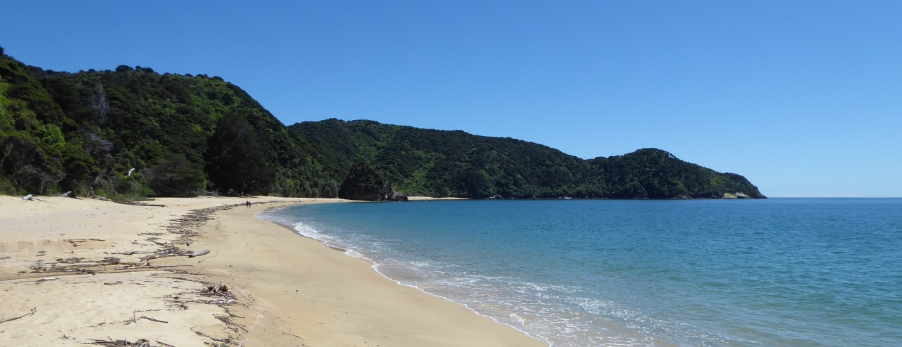
The track climbs over a low saddle and descends through a lush gully featuring lots of nikau to the sandy beach of Anapai Bay, whihch is about 45 min from Tōtaranui. At Anapai Bay there is a DOC campsite and toilet.
From Anapai Bay, Coast Track heads off the beach and climbs past some impressively-tall rata trees, then sidles the hillside to avoid a rocky section of the coast between Anapai Bay and Anatakapau Bay. Openings in the trees allow views of the coast below. The track descends gently to Anatakapau Bay.
Anatakapau Bay is a half-kilometre stretch of golden sand beach. Towards the northern end of the bay next to the DOC campsite, Coast Track climbs off the beach and heads inland toward Whariwharangi Hut, while Separation Point track continues along the beach. At the northern end of Anatakapau Bay the track climbs over a small headland with a rocky cove that divides Anatakapau Bay from Mutton Cove. Continue along the beach of Mutton Cove to its northern end, where the track climbs the hillside to gain the ridge that leads to Separation Point.
Beyond the official track end a rough route climbs down to the rocky headland. On calm days this a good spot for lunch, and you’ll enjoy great views across Golden Bay to Farewell Spit and across Tasman Bay to D’Urville Island. There is a seal colony on the rocks at the water’s edge and the point is home to numerous native seabirds.
The easiest way to return to Tōtaranui is by retracing your steps. Alternatively, you can take a slightly longer route by turning right at the track junction just before Separation Point and following Separation Point Track along a narrow coastal ridge westwards to connect with Coast Track at the saddle above Whariwharangi Bay (you would come this way if you had started your walk at Wainui Bay). Turn left here and follow Coast Track as it descends gently back to Anatakapau Bay.


Separation Point / Te Matau is at the northern end of Abel Tasman National Park and marks the geographic boundary between Golden Bay and Tasman Bay. It can be accessed from either Tōtaranui or Wainui Bay via Abel Tasman Coast Track, and is great as a day walk, showcasing golden sand beaches, lush coastal forest and providing the opportunity to see seals and seabirds.
| Details | |
| Distances (one way from Tōtaranui) | 3.2 km to Anapai Bay; 5.7 km to Anatakapau Bay; 7.2 km to Separation Point |
| Distances (one way from Wainui Bay) | 5.7 km to Whariwharangi Hut; 9 km to Separation Point |
| Time Required | 4 hr 30 min return Tōtaranui to Separation Point; 5 hr return Wainui Bay to Separation Point |
| Trail Type | Walking track |
| Physical Difficulty | Moderate |
| Uses | Walking and trail running |
| Direction | Either |
| Dog Access | Dogs are prohibited in Abel Tasman National Park |
2 hr 30 min from Nelson (Tōtaranui)
Separation Point can be reached as a day walk from either Tōtaranui or Wainui Bay.
To get to Tōtaranui from Nelson, follow SH60 all the way to Takaka. In Takaka, turn right onto Abel Tasman Drive and follow it through Motupipi, Pohara and into Wainui Bay. On the eastern side of Wainui Bay the road surface becomes gravel at the beginning of the climb over Pigeon Saddle. The road over Pigeon Saddle is windy and narrow, and can busy over summer, so drive with caution. At Tōtaranui there is a large parking area near the visitor centre at the beachfront. Tōtaranui visitor centre has lots of maps and information on the national park and tracks, as well as tide times and warnings. Tōtaranui is often used as the start or finish point for trampers doing Abel Tasman Coast Track, and is also a popular camping area in summer.
The alternative way to reach Separation Point is from the Wainui Bay car park (which is the northern end of Coast Track). On the eastern side of Wainui Bay, turn left onto McShane Road immediately before Tōtaranui Road switches to gravel at the start of the Pigeon Saddle climb. Follow McShane Road to the car park at the end. An information panel at the car park provides maps and information on times and distances.
From Tōtaranui
Separation Point is accessed via Abel Tasman Coast Track.
From the car park at Tōtaranui there are two options for heading north along Coast Track; the high tide route and the low tide route. The high tide route, which is slightly longer, heads back from the beach along the road that leads into Tōtaranui (lined with plane trees planted by the Gibbs family in 1865). It then follows the gravel road that leads around the head of the inlet. The low tide route follows the road along the beachfront from the car park (or you can walk on the beach), and crosses the inlet. The low tide route is obviously only suitable when the tide is out. Look for the orange DOC triangle on the far side of the inlet to see where the track continues. The track enters native bush on the opposite side of the and follows its edge to connect with the high tide route.
The track climbs over a low saddle and descends through a lush gully featuring lots of nikau to the sandy beach of Anapai Bay, whihch is about 45 min from Tōtaranui. At Anapai Bay there is a DOC campsite and toilet.
From Anapai Bay, Coast Track heads off the beach and climbs past some impressively-tall rata trees, then sidles the hillside to avoid a rocky section of the coast between Anapai Bay and Anatakapau Bay. Openings in the trees allow views of the coast below. The track descends gently to Anatakapau Bay.
Anatakapau Bay is a half-kilometre stretch of golden sand beach. Towards the northern end of the bay next to the DOC campsite, Coast Track climbs off the beach and heads inland toward Whariwharangi Hut, while Separation Point track continues along the beach. At the northern end of Anatakapau Bay the track climbs over a small headland with a rocky cove that divides Anatakapau Bay from Mutton Cove. Continue along the beach of Mutton Cove to its northern end, where the track climbs the hillside to gain the ridge that leads to Separation Point.
Beyond the official track end a rough route climbs down to the rocky headland. On calm days this a good spot for lunch, and you’ll enjoy great views across Golden Bay to Farewell Spit and across Tasman Bay to D’Urville Island. There is a seal colony on the rocks at the water’s edge and the point is home to numerous native seabirds.
The easiest way to return to Tōtaranui is by retracing your steps. Alternatively, you can take a slightly longer route by turning right at the track junction just before Separation Point and following Separation Point Track along a narrow coastal ridge westwards to connect with Coast Track at the saddle above Whariwharangi Bay (you would come this way if you had started your walk at Wainui Bay). Turn left here and follow Coast Track as it descends gently back to Anatakapau Bay.
Updated 26 June 2023