Captain Creek Hut is the easternmost hut on the Pelorus Track (which doubles as the Te Araroa Trail). Located on a bend in the crystal-clear Pelorus River, it is the first hut encountered in Mount Richmond Forest Park by southbound Te Araroa trampers.
| Details | |
| Length | 8.3 km from Pelorus road end; 4.8 km from Middy Hut |
| Time Required | 3-4 hr from Pelorus road end; 2 hr from Middy Hut |
| Trail Type | Tramping track |
| Physical Difficulty | Moderate |
| Uses | Walking and trail running |
| Direction | Either |
If any layers fail to load, try clearing your cache and refreshing the page.
1 hr from Nelson
The beginning of Pelorus Track is located at the end of Maungatapu Road. On SH6, immediately west of Pelorus River bridge, turn onto Maungatapu Road, and follow it for 14 km to the road end, where there is a parking area and sign displaying a map and track information.
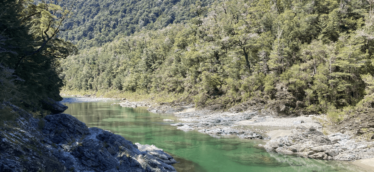
Pelorus Track heads along the true left of the Pelorus River. The track is tramping grade, and though it is mostly easy-going, there are places where you will have to clamber over tree roots and rocks. After 1 km a swing bridge crosses a side stream, Scott Creek, and after a further kilometre you will cross the boundary into Mt Richmond Forest Park. In several places there are worn tracks down to the river below, which flows with beautiful clarity and an emerald hue.
Beyond Emerald Pool, the track climbs higher above the river to the 200 m elevation contour, sidling the valley side through forest that is an attractive mix of beech, rimu, matai, halls tōtara and miro. The track descends the valley side to follow alongside the river, then climbs again slightly before the turnoff to Captain Creek Hut.
The hut is located in a grassy clearing on the true left of the river. There riverbed is immediately accessible from the hut.
| Captain Creek Hut | |
| Hut Type | Standard Hut |
| Capacity | 6 bunks |
| Bookings | Not required; first in, first served |
| Fee | 1 Standard Hut Ticket |
| Altitude | 110 m |
Captain Creek Hut to Middy Hut
From Captain Creek Hut the track continues along the true left of the river, crossing a side tributary, Captain Creek. Soon after a swing bridge crosses the Pelorus on a section where the river flows through a spectacular section of gorge. Now on the true right, the track sidles the hillside high above the river, crossing Fishtail Stream via a swing bridge and continuing on to Middy Hut.


Captain Creek Hut is the easternmost hut on the Pelorus Track (which doubles as the Te Araroa Trail). Located on a bend in the crystal-clear Pelorus River, it is the first hut encountered in Mount Richmond Forest Park by southbound Te Araroa trampers.
| Details | |
| Length | 8.3 km from Pelorus road end; 4.8 km from Middy Hut |
| Time Required | 3-4 hr from Pelorus road end; 2 hr from Middy Hut |
| Trail Type | Tramping track |
| Physical Difficulty | Moderate |
| Uses | Walking and trail running |
| Direction | Either |
1 hr from Nelson
The beginning of Pelorus Track is located at the end of Maungatapu Road. On SH6, immediately west of Pelorus River bridge, turn onto Maungatapu Road, and follow it for 14 km to the road end, where there is a parking area and sign displaying a map and track information.
Pelorus Track heads along the true left of the Pelorus River. The track is tramping grade, and though it is mostly easy-going, there are places where you will have to clamber over tree roots and rocks. After 1 km a swing bridge crosses a side stream, Scott Creek, and after a further kilometre you will cross the boundary into Mt Richmond Forest Park. In several places there are worn tracks down to the river below, which flows with beautiful clarity and an emerald hue.
Beyond Emerald Pool, the track climbs higher above the river to the 200 m elevation contour, sidling the valley side through forest that is an attractive mix of beech, rimu, matai, halls tōtara and miro. The track descends the valley side to follow alongside the river, then climbs again slightly before the turnoff to Captain Creek Hut.
The hut is located in a grassy clearing on the true left of the river. There riverbed is immediately accessible from the hut.
| Captain Creek Hut | |
| Hut Type | Standard Hut |
| Capacity | 6 |
| Bookings | Not required; first in, first served |
| Fee | No fee |
| Altitude | 110 m |
From Captain Creek Hut the track continues along the true left of the river, crossing a side tributary, Captain Creek. Soon after a swing bridge crosses the Pelorus on a section where the river flows through a spectacular section of gorge. Now on the true right, the track sidles the hillside high above the river, crossing Fishtail Stream via a swing bridge and continuing on to Middy Hut.
Updated 26 January 2022