Located in the northwest of Golden Bay, Knuckle Hill Track is a short deviation off of Kaituna Track to a prominent knob, Knuckle Hill (506 m). The summit provides good views of Whanganui Inlet and the forested hill country inland of the Kahurangi coast.
| Details | |
| Length | 9.4 km return |
| Time Required | 2-3 hr return |
| Trail Type | Walking track |
| Physical Difficulty | Moderate |
| Uses | Walking, trail running and MTB |
| Direction | Return (up and down) |
| Start Elevation | 100 m |
| Max Elevation | 506 m |
| Amenities | There are no toilets or drinking water sources along the track |
If any layers fail to load, try clearing your cache and refreshing the page.
This elevation profile should be considered approximate. Its accuracy is determined by the quality of data available.
Kaituna Track
Walking and trail running
2 hr 30 min from Nelson | 1 hr from Takaka
From Takaka, head north along State Highway 60 to Collingwood, which is where State Highway 60 ends. Continue north along Collingwood-Puponga Main Rd to Pakawau and turn left onto Pakawau Bush Rd, which becomes gravel as it reaches Whanganui Inlet. Dry Rd continues around the inlet, with several causeways and bridges crossing its many tidal arms. You will see a DOC sign indicating the left-hand turnoff to the car park, which is 500 m up a gravel side road.
Knuckle Hill Track branches off of Kaituna Track. The majority of Kaituna Track is within Northwest Nelson Forest Park. The summit of Knuckle Hill delineates the boundary of Kahurangi National Park.
From the car park, Kaituna Track follows an old forestry road along a spur through regenerating mixed podocarp forest. The track has a gentle uphill gradient most of the way. Occasional gaps in the trees allow glimpses towards the coast, and Knuckle Hill can be see ahead.
After 4 km you will reach the turnoff to Knuckle Hill. If you’re riding you’ll have to leave your bike here as the remaining distance is unrideable. The track emerges into pakihi scrub of manuka and tussock, with sandy granite rocks underfoot. At this point the track steepens as you climb the remaining 150 vertical metres to the trig at the summit.
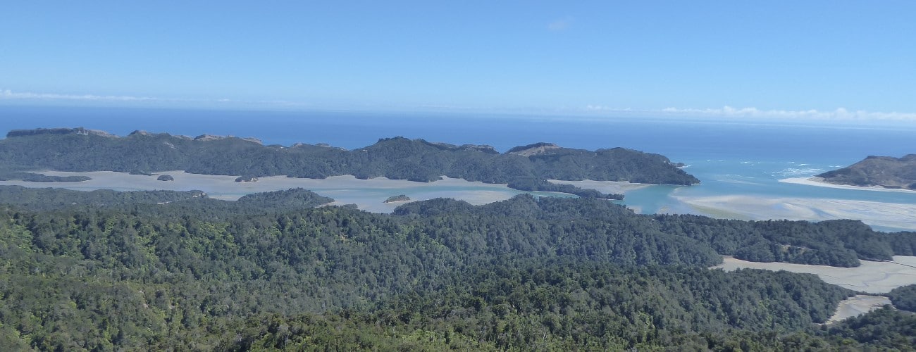
The 506 m elevation summit offers stunning views; Knuckle Hill is the only sufficiently-prominent location able to provide views of the entire Whanganui Inlet. You will also enjoy views of western side of Burnett Range, the forested hill country southwest between the coast and Wakamarama Range, and on clear days you may be able to see Kahurangi Point Lighthouse.
Return from the summit the way you came. Once back at the Kaituna Track, turn right to head back to the car park. Otherwise, Kaituna Track heads left and continues for a further 14 km to Aorere Valley.


Located in the northwest of Golden Bay, Knuckle Hill Track is a short deviation off of Kaituna Track to a prominent knob, Knuckle Hill (506 m). The summit provides good views of Whanganui Inlet and the forested hill country inland of the Kahurangi coast.
| Details | |
| Length | 9.4 km return |
| Time Required | 2-3 hr |
| Trail Type | Walking track |
| Physical Difficulty | Moderate |
| Uses | Walking, trail running and MTB |
| Direction | Return (up and down) |
| Start Elevation | 100 m |
| Max Elevation | 506 m |
| Amenities | There are no toilets or drinking water sources along the track |
This elevation profile should be considered approximate. Its accuracy is determined by the quality of data available.
2 hr 30 min from Nelson | 1 hr from Takaka
From Takaka, head north along State Highway 60 to Collingwood, which is where State Highway 60 ends. Continue north along Collingwood-Puponga Main Rd to Pakawau and turn left onto Pakawau Bush Rd, which becomes gravel as it reaches Whanganui Inlet. Dry Rd continues around the inlet, with several causeways and bridges crossing its many tidal arms. You will see a DOC sign indicating the left-hand turnoff to the car park, which is 500 m up a gravel side road.
Knuckle Hill Track branches off of Kaituna Track. The majority of Kaituna Track is within Northwest Nelson Forest Park. The summit of Knuckle Hill delineates the boundary of Kahurangi National Park.
From the car park, Kaituna Track follows an old forestry road along a spur through regenerating mixed podocarp forest. The track has a gentle uphill gradient most of the way. Occasional gaps in the trees allow glimpses towards the coast, and Knuckle Hill can be see ahead.
After 4 km you will reach the turnoff to Knuckle Hill. If you’re riding you’ll have to leave your bike here as the remaining distance is unrideable. The track emerges into pakihi scrub of manuka and tussock, with sandy granite rocks underfoot. At this point the track steepens as you climb the remaining 150 vertical metres to the trig at the summit.
The 506 m elevation summit offers stunning views; Knuckle Hill is the only sufficiently-prominent location able to provide views of the entire Whanganui Inlet. You will also enjoy views of western side of Burnett Range, the forested hill country southwest between the coast and Wakamarama Range, and on clear days you may be able to see Kahurangi Point Lighthouse.
Return from the summit the way you came. Once back at the Kaituna Track, turn right to head back to the car park. Otherwise, Kaituna Track heads left and continues for a further 14 km to Aorere Valley.
Kaituna Track
Walking and trail running
Updated 7 February 2019