Maitland Ridge Track connects Beeby’s Knob with Red Hills Hut, creating an expert-grade circuit. The track was developed by the MTB Trails Trust and now doubles as Te Araroa Trail.
| Details | |
| Length | Maitland Ridge alone is 7.9 km; full circuit incl. Wots Up Doc and Red Hills Track is 24.5 km |
| Time Required | 3-4 hr (full circuit, MTB) |
| Trail Type | Shared track/Tramping track/4WD road |
| Physical Difficulty | Moderate |
| Technical Difficulty | Expert |
| Uses | Walking, trail running and MTB |
| Direction | Either |
| Start Elevation | 560 m |
| Max Elevation | 1330 m |
If any layers fail to load, try clearing your cache and refreshing the page.
1 hr 5 min from Nelson
The easiest way to complete Maitland Ridge Circuit is by starting at Six Mile car park. From Nelson, head south along SH6 and turn left at Belgrove onto Wai-iti Valley Rd. Continue all the way to the junction with SH63, where you will turn left and continue over Wairau Pass for 4 km. About 2 min past the Rainbow Skifield turnoff you will see a DOC sign indicating the car park on the left (just before the one way bridge).
Alternatively, you can park on Tophouse Rd at the bottom of Beeby’s Knob 4WD Road and climb to the beginning of Wots up Doc, though this will mean you will have to do an additional 200 m of climbing.
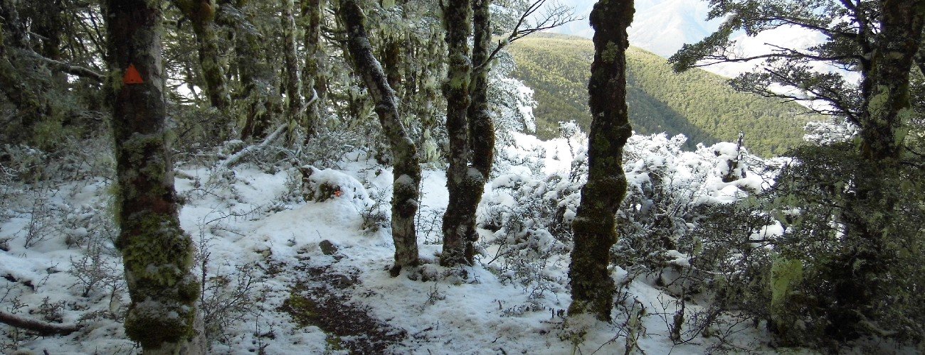
From Six Mile car park, follow the track a short distance to the junction with the track that heads left to join Wots up Doc. This track climbs for 3.9 km to connect with Wots up Doc, about 1 km above From Tophouse Rd. Wots Up Doc sweeps back and forth across the 4WD road, the latter taking a more direct route upwards. Near the top of the range the track heads through a section of beech forest with mossy undergrowth. At the tree line you will reach the turnoff to Maitland Ridge Track; continuing straight is the way to Beeby’s Knob (1442 m) and Beeby’s Hut.
Maitland Ridge Track descends nearly non-stop through stunted mountain beech to a saddle at 1020 m elevation, then climbs gradually through a series of zig-zags toward point 1202 m, passing clearings that allow impressive views across Wairau Valley to Raglan Range. After point 1202 m the track goes through a slightly-technical descent, before crossing another saddle and climbing again to the top of the final descent down a rough 4WD track down to Red Hills Hut.
| Red Hills Hut | |
| Hut Type | Standard Hut |
| Capacity | 6 bunks |
| Bookings | Not required; first in, first served |
| Fee | 1 Standard Hut Ticket |
| Facilities | Mattresses only (no heating) |
| Altitude | 910 m |
From Red Hills Hut, descend down Red Hills Track (a 4WD road). After 5 km the 4WD road becomes a shared track, which heads through beech forest for 2 km back to Six Mile car park.
Maitland Ridge Track connects Beeby’s Knob with Red Hills Hut, creating an expert-grade circuit. The track was developed by the MTB Trails Trust and now doubles as Te Araroa Trail.
| Details | |
| Length | Maitland Ridge alone is 7.9 km; full circuit incl. Wots Up Doc and Red Hills Track is 24.5 km |
| Time Required | 3-4 hr (full circuit, MTB) |
| Trail Type | Shared track/Tramping track/4WD road |
| Physical Difficulty | Moderate |
| Technical Difficulty | Expert |
| Uses | Walking, trail running and MTB |
| Direction | Either |
| Start Elevation | 560 m |
| Max Elevation | 1330 m |
1 hr 5 min from Nelson
The easiest way to complete Maitland Ridge Circuit is by starting at Six Mile car park. From Nelson, head south along SH6 and turn left at Belgrove onto Wai-iti Valley Rd. Continue all the way to the junction with SH63, where you will turn left and continue over Wairau Pass for 4 km. About 2 min past the Rainbow Skifield turnoff you will see a DOC sign indicating the car park on the left (just before the one way bridge).
Alternatively, you can park on Tophouse Rd at the bottom of Beeby’s Knob 4WD Road and climb to the beginning of Wots up Doc, though this will mean you will have to do an additional 200 m of climbing.
From Six Mile car park, follow the track a short distance to the junction with the track that heads left to join Wots up Doc. This track climbs for 3.9 km to connect with Wots up Doc, about 1 km above From Tophouse Rd. Wots Up Doc sweeps back and forth across the 4WD road, the latter taking a more direct route upwards. Near the top of the range the track heads through a section of beech forest with mossy undergrowth. At the tree line you will reach the turnoff to Maitland Ridge Track; continuing straight is the way to Beeby’s Knob (1442 m) and Beeby’s Hut.
Maitland Ridge Track descends nearly non-stop through stunted mountain beech to a saddle at 1020 m elevation, then climbs gradually through a series of zig-zags toward point 1202 m, passing clearings that allow impressive views across Wairau Valley to Raglan Range. After point 1202 m the track goes through a rocky descent, before crossing another saddle and climbing again to the top of the final descent down a rough 4WD track down to Red Hills Hut.
| Red Hills Hut | |
| Hut Type | Standard Hut |
| Capacity | 6 bunks |
| Bookings | Not required; first in, first served |
| Fee | 1 Standard Hut Ticket |
| Facilities | Mattresses only (no heating) |
| Altitude | 910 m |
From Red Hills Hut, descend down Red Hills Track (a 4WD road). After 5 km the 4WD road becomes a shared track, which heads through beech forest for 2 km back to Six Mile car park.
Updated 18 February 2022