Mt Royal (1365 m) is a peak at the eastern end of Mt Richmond Forest Park, in Marlborough. It can be climbed in a single day from Quartz Creek, or as an overnight trip via Devils Creek Hut on the Wakamarina Track. The views from the summit are worth the steep climb up.
| Details | |
| Length | 17 km to summit from Quartz Creek (return); 13.1 km to Devils Creek Hut from Quartz Creek (one way) |
| Time Required | 7-8 hr to summit from Quartz Creek (return); 6-7 hr to Devils Creek Hut from Quartz Creek (one way) |
| Trail Type | Tramping track |
| Physical Difficulty | Hard |
| Uses | Walking and trail running |
| Start Elevation | 160 m (Quartz Valley) |
| Max Elevation | 1365 m |
| Dog Access | Permit required for Mt Richmond Forest Park; see local DOC office |
If any layers fail to load, try clearing your cache and refreshing the page.
This elevation profile should be considered approximate. Its accuracy is determined by the quality of data available.
1 hr 45 min from Nelson | 40 min from Blenheim
Mt Royal can be done as a day trip or an overnight trip.
For day trips, the easiest way to access the summit is via Quartz Creek, which is located on the north side of Wairau River. North Bank Rd begins immediately north of the Wairau River Bridge on State Highway 6 (5 km north of Renwick). Follow North Bank Rd west for 21 km and turn right onto Fabians Valley Rd, then right onto Bartletts Rd. Follow Barletts Rd for 5 km to Quartz Creek Flat, where you will see a DOC sign marking the start of the track.
Mt Royal can also be climbed as part of a one-way day trip or overnight trip between Wakamarina Valley and Quartz Creek, with Devils Creek Hut providing accommodation for overnight trips. This will require you to have vehicle transport at both track ends, which are about 73 km apart by car.
Logging and high fire risk will close access.
The route begins as a vague 4WD track and heads up the wide bed of the clear-flowing Quartz Creek, where Mt Royal can be seen at the head of the valley. This initial section can be described as ‘pick-your-own-way’, where you just try to pick the smoothest path up the creekbed. There are not many DOC markers and you will have to cross Quartz Creek multiple times; this is quite refreshing on warm summer days, though in winter it is less pleasant. After 2.7 km the route leaves the creekbed and follows a 4WD track through scrub to the foot of the spur where the climb begins. Note that the Quartz Creek part of the route will likely be impassable following heavy rain.
At the foot of the spur there is another DOC sign that marks the Mt Richmond Forest Park boundary. This is where Mt Royal Track splits off the 4WD track and begins climbing steeply up a beech-forested spur. Initially the track base is clay, which can be quite greasy when wet. Further up the climb involves a lot of negotiating roots, rocks and a few boulders, with only a couple of flat sections to give you some respite. After having gained 950 m elevation in a little over 3.2 km (30% gradient), you will reach the top of the range (1198 m) around 2 hr after leaving the valley floor. The track heads to the right and undulates along the top of the range for another kilometre to the treeline just below the summit.
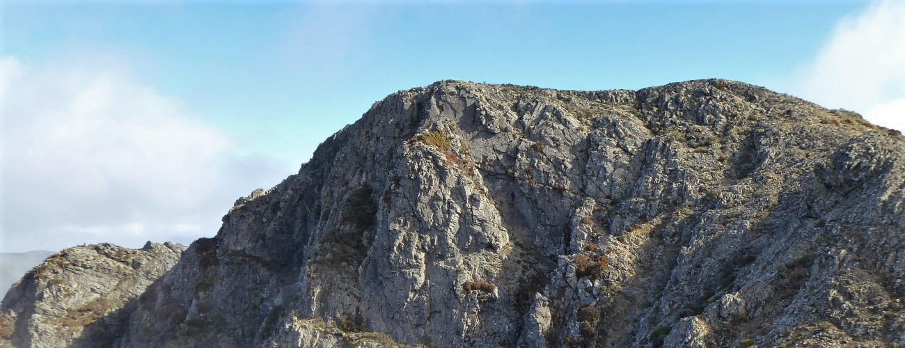
The bare summit features dramatic craggy bluffs that drop away to the south. Enjoy the views over Wairau Valley and of Mt Fishtail across the valley to the west.
To return to Quartz Creek, turn around and head back down the same way you came up. If you are continuing to Devils Creek Hut (5.3 km away), follow the marker poles over the other side of the summit, which leads to the spur that the track follows to the hut.


Mt Royal is an alpine environment, so proper preparation and care should be made to ensure a safe trip. The track reaches a high elevation and is exposed above the treeline, so proper outdoor clothing is essential. You must always be prepared for freezing conditions and take extreme care if snow and ice and are present. Do not rely on the Blenheim weather forecast as the alpine conditions in Mt Richmond Forest Park are likely to be drastically different. Make sure you carry plenty of water with you as there are no water sources beyond Quartz Creek.
See the Mountain Safety Council website for useful information on preparing for the outdoors.
Mt Royal (1365 m) is a peak at the eastern end of Mt Richmond Forest Park, in Marlborough. It can be climbed in a single day from Quartz Creek, or as an overnight trip via Devils Creek Hut on the Wakamarina Track. The views from the summit are worth the steep climb up.
| Details | |
| Length | 17 km to summit from Quartz Creek (return); 13.1 km to Devils Creek Hut from Quartz Creek (one way) |
| Time Required | 7-8 hr to summit from Quartz Creek (return); 6-7 hr to Devils Creek Hut from Quartz Creek (one way) |
| Trail Type | Tramping track |
| Physical Difficulty | Hard |
| Uses | Walking and trail running |
| Start Elevation | 160 m (Quartz Valley) |
| Max Elevation | 1365 m |
| Dog Access | Permit required for Mt Richmond Forest Park; see local DOC office |
1 hr 45 min from Nelson | 40 min from Blenheim
Mt Royal can be done as a day trip or an overnight trip.
For day trips, the easiest way to access the summit is via Quartz Creek, which is located on the north side of Wairau River. North Bank Rd begins immediately north of the Wairau River Bridge on State Highway 6 (5 km north of Renwick). Follow North Bank Rd west for 21 km and turn right onto Fabians Valley Rd, then right onto Bartletts Rd. Follow Barletts Rd for 5 km to Quartz Creek Flat, where you will see a DOC sign marking the start of the track.
Mt Royal can also be climbed as part of a one-way day trip or overnight trip between Wakamarina Valley and Quartz Creek, with Devils Creek Hut providing accommodation for overnight trips. This will require you to have vehicle transport at both track ends, which are about 73 km apart by car.
Logging and high fire risk will close access.
The route begins as a vague 4WD track and heads up the wide bed of the clear-flowing Quartz Creek, where Mt Royal can be seen at the head of the valley. This initial section can be described as ‘pick-your-own-way’, where you just try to pick the smoothest path up the creekbed. There are not many DOC markers and you will have to cross Quartz Creek multiple times; this is quite refreshing on warm summer days, though in winter it is less pleasant. After 2.7 km the route leaves the creekbed and follows a 4WD track through scrub to the foot of the spur where the climb begins. Note that the Quartz Creek part of the route will likely be impassable following heavy rain.
At the foot of the spur there is another DOC sign that marks the Mt Richmond Forest Park boundary. This is where Mt Royal Track splits off the 4WD track and begins climbing steeply up a beech-forested spur. Initially the track base is clay, which can be quite greasy when wet. Further up the climb involves a lot of negotiating roots, rocks and a few boulders, with only a couple of flat sections to give you some respite. After having gained 950 m elevation in a little over 3.2 km (30% gradient), you will reach the top of the range (1198 m) around 2 hr after leaving the valley floor. The track heads to the right and undulates along the top of the range for another kilometre to the treeline just below the summit.
The bare summit features dramatic craggy bluffs that drop away to the south. Enjoy the views over Wairau Valley and of Mt Fishtail across the valley to the west.
To return to Quartz Creek, turn around and head back down the same way you came up. If you are continuing to Devils Creek Hut (5.3 km away), follow the marker poles over the other side of the summit, which leads to the spur that the track follows to the hut.
Mt Royal is an alpine environment, so proper preparation and care should be made to ensure a safe trip. The track reaches a high elevation and is exposed above the treeline, so proper outdoor clothing is essential. You must always be prepared for freezing conditions and take extreme care if snow and ice and are present. Do not rely on the Blenheim weather forecast as the alpine conditions in Mt Richmond Forest Park are likely to be drastically different. Make sure you carry plenty of water with you as there are no water sources beyond Quartz Creek.
See the Mountain Safety Council website for useful information on preparing for the outdoors.