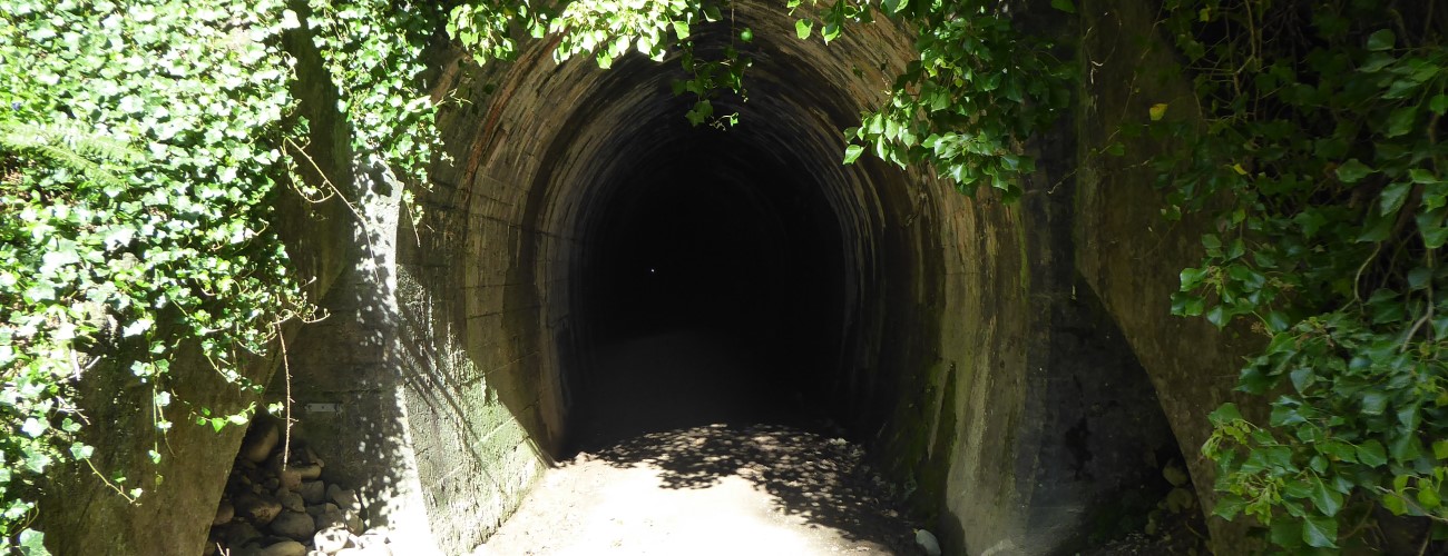
The Wakefield to Tapawera section of Tasman’s Great Taste Trail traces part of the alignment of the historic Nelson-Glenhope Railway. A feature of this section is the 1.35 km-long Spooners Tunnel, which was completed in 1893 and used until 1955, when the railway was decommissioned. The tunnel lay mostly unused for 60 years until it was re-opened in 2016 to become part of the Great Taste Trail.
| Details | |
| Length | 11.3 km Wakefield to Belgrove; 15.7 km Belgrove to Kohatu (via Spooners Tunnel); 7.5 km Kohatu to Tapawera |
| Time Required | 2 hr – 2 hr 30 min one way Wakefield to Tapawera (biking) |
| Trail Type | Shared track |
| Physical Difficulty | Easy |
| Technical Difficulty | Easy |
| Uses | Walking, trail running and MTB |
| Direction | Either |
| Note | There is no lighting in the tunnel; make sure you bring a decent headlight or torch |
If any layers fail to load, try clearing your cache and refreshing the page.
25 min from central Nelson (Wakefield) | 55 min from central Nelson (Tapawera)
The northern end of this section of the Great Taste Trail begins at Wakefield, 15 km south of Richmond along State Highway 6 (SH6). It is a direct continuation of the Richmond to Wakefield section of the trail. The southern/western end is at Tapawera, which is 40 min min south of Richmond along SH6 and Motueka Valley Highway.
Wai-iti Domain
Wai-iti Domain is 6 km south of Wakefield along SH6, on the left side of the highway immediately before it crosses Wai-iti River. There is unlimited parking here.
Belgrove
On the left side of SH6, directly opposite Belgrove Tavern, there is a parking area next to the historic Belgrove Windmill. Parking here is limited; on weekdays, only a handful of spaces are available. On weekends and public holidays only a larger part of the area is open for parking, though this is still limited to around 50 spaces. This is the closest place you can park to the northern portal of the tunnel.
Norris Gully Reserve
Located in Norris Gully on the southern side of Spooners Saddle. This is the safest place to park to access the southern portal of Spooners Tunnel, which is about 1 km away. There is unlimited parking here and the reserve is a good spot for a picnic.
The trail is regularly marked with blue plastic posts and informative signs.
At Wakefield, the trail heads west from the Edward St-SH6 intersection to Wai-iti River Bridge, where it goes off-road and follows the true left of Wai-iti River to a bridge across it just downstream of Hoult Valley Rd. From Hoult Valley Rd the trail crosses SH6 (be careful crossing here)and runs alongside it for 1.6 km to Wai-iti Domain. At Wai-iti Domain, the trail heads along the true right of Wai-iti River for several kilometres before joining Quail Valley Rd and following it to SH6. The trail crosses SH6 (take care when crossing), goes over Pretty Bridge Stream and reaches Belgrove Tavern.
From Belgrove, the trail follows the northbound lane of SH6 for a few hundred metres before crossing to the other side (take care when crossing). The trail continues alongside the southbound lane, crossing Wai-iti Valley Road (the main road to Nelson Lakes) and joins the former rail alignment at Tunnel Road (a forestry road). Tunnel Road deviates from the highway and heads up Railway Gully. The road has a very gentle uphill gradient as it heads up the gully. The northern tunnel portal is 4.5 km up Tunnel Road.
The tunnel slopes slightly upward from north to south. There is no lighting so you will need a torch or headlight to see where you’re going. The temperature in the tunnel can be much cooler than outside, and there can be a draft as cool air drains toward the northern end. Pack an extra layer just in case.
At the southern tunnel portal there is a toilet. The trail leaves the tunnel gully, crosses a gravel parking area and continues alongside SH6, before crossing it and entering Norris Gully Reserve, which is a grassed rest area with exotic plantings. Beyond the reserve the trail passes beneath a bridge under the highway and runs parallel to the southbound lane along the historic rail alignment. There is a road crossing at Valley Road, where a sign indicates the start of Golden Downs Trail, a Heartland Ride leading to St Arnaud. There is another highway crossing 1.2 km further on, then it’s 2.5 km to the SH6-Motueka Valley Highway intersection at Kohatu. There is a toilet a few hundred metres along the trail beyond Kohatu.
Continuing on from Kohatu, the trail heads northward alongside pine plantation and farmland on the eastern side of Motueka Valley Highway, roughly following the historic rail alignment. 2.1 km past Kohatu there is a crossing to the other side of the highway, and a little further on the trail descends an old river terrace along a historic railway feature called Maniaroa Cutting. The trail follows a long straight in the highway alongside extensive hop plantations, then crosses back to the other side. A little while later there is an incomplete section of trail a few hundred metres in length, which requires some on-road travel.
The last section into Tapawera deviates from the highway and heads through Tapawera Recreational Reserve. The trail crosses Maitai Cres and reconnects to the highway in the centre of the village, right across from the information kiosk and next to the public toilets. This is the current terminus of the Great Taste Trail.
The name ‘Tapawera’ means ‘hot edge’, as in the burnt fringe of the forest.


The Wakefield to Tapawera section of Tasman’s Great Taste Trail traces part of the alignment of the historic Nelson-Glenhope Railway. A feature of this section is the 1.35 km-long Spooners Tunnel, which was completed in 1893 and used until 1955, when the railway was decommissioned. The tunnel lay mostly unused for 60 years until it was re-opened in 2016 to become part of the Great Taste Trail.
| Details | |
| Length | 11.3 km Wakefield to Belgrove; 15.7 km Belgrove to Kohatu (via Spooners Tunnel); 7.5 km Kohatu to Tapawera |
| Time Required | 2 hr – 2 hr 30 min one way Wakefield to Tapawera (biking) |
| Trail Type | Shared track |
| Physical Difficulty | Easy |
| Technical Difficulty | Easy |
| Uses | Walking, trail running and MTB |
| Direction | Either |
| Note | There is no lighting in the tunnel; make sure you bring a decent headlight or torch |
25 min from central Nelson (Wakefield) | 55 min from central Nelson (Tapawera)
The northern end of this section of the Great Taste Trail begins at Wakefield, 15 km south of Richmond along State Highway 6 (SH6). It is a direct continuation of the Richmond to Wakefield section of the trail. The southern/western end is at Tapawera, which is 40 min min south of Richmond along SH6 and Motueka Valley Highway.
Wai-iti Domain
Wai-iti Domain is 6 km south of Wakefield along SH6, on the left side of the highway immediately before it crosses Wai-iti River. There is unlimited parking here.
Belgrove
On the left side of SH6, directly opposite Belgrove Tavern, there is a parking area next to the historic Belgrove Windmill. Parking here is limited; on weekdays, only a handful of spaces are available. On weekends and public holidays only a larger part of the area is open for parking, though this is still limited to around 50 spaces. This is the closest place you can park to the northern portal of the tunnel.
Norris Gully Reserve
Located in Norris Gully on the southern side of Spooners Saddle. This is the safest place to park to access the southern portal of Spooners Tunnel, which is about 1 km away. There is unlimited parking here and the reserve is a good spot for a picnic.
The trail is regularly marked with blue plastic posts and informative signs.
At Wakefield, the trail heads west from the Edward St-SH6 intersection to Wai-iti River Bridge, where it goes off-road and follows the true left of Wai-iti River to a bridge across it just downstream of Hoult Valley Rd. From Hoult Valley Rd the trail crosses SH6 (be careful crossing here)and runs alongside it for 1.6 km to Wai-iti Domain. At Wai-iti Domain, the trail heads along the true right of Wai-iti River for several kilometres before joining Quail Valley Rd and following it to SH6. The trail crosses SH6 (take care when crossing), goes over Pretty Bridge Stream and reaches Belgrove Tavern.
From Belgrove, the trail follows the northbound lane of SH6 for a few hundred metres before crossing to the other side (take care when crossing). The trail continues alongside the southbound lane, crossing Wai-iti Valley Road (the main road to Nelson Lakes) and joins the former rail alignment at Tunnel Road (a forestry road). Tunnel Road deviates from the highway and heads up Railway Gully. The road has a very gentle uphill gradient as it heads up the gully. The northern tunnel portal is 4.5 km up Tunnel Road.
The tunnel slopes slightly upward from north to south. There is no lighting so you will need a torch or headlight to see where you’re going. The temperature in the tunnel can be much cooler than outside, and there can be a draft as cool air drains toward the northern end. Pack an extra layer just in case.
At the southern tunnel portal there is a toilet. The trail leaves the tunnel gully, crosses a gravel parking area and continues alongside SH6, before crossing it and entering Norris Gully Reserve, which is a grassed rest area with exotic plantings. Beyond the reserve the trail passes beneath a bridge under the highway and runs parallel to the southbound lane along the historic rail alignment. There is a road crossing at Valley Road, where a sign indicates the start of Golden Downs Trail, a Heartland Ride leading to St Arnaud. There is another highway crossing 1.2 km further on, then it’s 2.5 km to the SH6-Motueka Valley Highway intersection at Kohatu. There is a toilet a few hundred metres along the trail beyond Kohatu.
Continuing on from Kohatu, the trail heads northward alongside pine plantation and farmland on the eastern side of Motueka Valley Highway, roughly following the historic rail alignment. 2.1 km past Kohatu there is a crossing to the other side of the highway, and a little further on the trail descends an old river terrace along a historic railway feature called Maniaroa Cutting. The trail follows a long straight in the highway alongside extensive hop plantations, then crosses back to the other side. A little while later there is an incomplete section of trail a few hundred metres in length, which requires some on-road travel.
The last section into Tapawera deviates from the highway and heads through Tapawera Recreational Reserve. The trail crosses Maitai Cres and reconnects to the highway in the centre of the village, right across from the information kiosk and next to the public toilets. This is the current terminus of the Great Taste Trail.
The name ‘Tapawera’ means ‘hot edge’, as in the burnt fringe of the forest.
Updated 15 November 2020