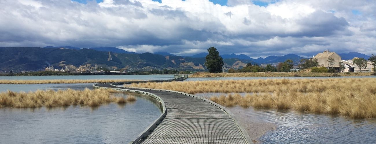
The Richmond to Mapua section of the Great Taste Trail traces the coastline of Waimea Inlet (the largest estuary in the South Island), takes in the beachfront of Rabbit Island and finishes with a ferry ride to Mapua. The trail provides an off-road link between Nelson and Rabbit Island and its flat gradient makes it enjoyable for walkers, runners and bikers of all abilities. Known as the Coastal Route, it is particularly stunning at high tide.
| Details | |
| Length | 19.8 km Richmond to ferry at western end of Rabbit Island |
| Time Required | 1 hr – 1 hr 30 min (by MTB) |
| Trail Type | Shared track |
| Physical Difficulty | Easy |
| Technical Difficulty | Easy |
| Uses | Walking, trail running and MTB |
| Direction | Either |
| Note | The ferry to Mapua runs seasonally. Check timetable here. |
If any layers fail to load, try clearing your cache and refreshing the page.
Conifer Park tracks
Walking, running and MTB
Great Taste Trail: Richmond to Wakefield
Walking, running and MTB
Great Taste Trail: Mapua to Motueka (via Mapua Ferry)
Walking, running and MTB
Moturoa Forest Track
Walking, running and MTB
Whakatu Coastal Pathway
Walking, running and cycling

15 min from central Nelson
As it links directly to Nelson’s network of urban routes, namely Whakatu Coastal Pathway and Railway Reserve Pathway, most Nelson residents can access the trail directly from home with little on-road travel.
If you want to leave your car to complete a there-and-back journey, there are car parks at Sandeman Road, Beach Rd, Champion Road, Saxton Field, Point Road (Monaco) and Nelson airport; all of the latter locations provide suitable starting points, depending on how long you want your trip to be.
The trail is regularly marked with blue plastic posts and informative signs.
This section of the Great Taste Trail begins next to the Reservoir Creek underpass beneath Richmond Deviation, opposite Richmond Aquatic Centre. The first two kilometres follow the coastline around the back of Richmond’s industrial area and the racecourse. Along this section there is access to Beach Rd, Headingly Ln, Estuary Pl and Sandeman Rd. Nelson Pine industries is passed after 5 km. Beyond here you’ll cross sections of boardwalk that span the inlet; these are really nice when the tide is in. The trail turns south at Best Island Road and then west onto Lower Queen street; this is the longest section directly open to the road. At the end of Lower Queen Street the trail follows a stop bank to C.B. Kidson Bridge, which crosses Waimea River.
The trail passes the end of Cotterell Rd and runs through farmland for 1.9 km to Redwood Rd (the road to Rabbit Island). It crosses the pedestrian bridge attached to the road bridge to Rough Island and then the causeway to Rabbit Island. For the next 1.6 km it runs alongside plantation forest on the left side of Ken Beck Dr all the way to Rabbit Island beachfront. Rabbit Island Beach is very popular and provides a safe place to swim in summer. There are toilets, changing rooms and barbecues located along the beach. The trail follows the beachfront road west through plantation forest to the western end of the island and the tidal channel, on the other side of which is Mapua. A ferry operates seasonally between Rabbit Island and Mapua; timetable and fare information can be found on the Mapua Ferry website.
If you intend to return back to Nelson rather than take the ferry, consider continuing along Moturoa Forest Track which follows the western coast of the island and connects back to Great Taste Trail next to the channel between Rabbit Island and Rough Island.
Be aware that there are few amenities along the trail between Richmond and Mapua. There are toilet facilities at the end of Sandeman Road and at the Rabbit Island beachfront. There are also drinking water taps at Rabbit Island. There are no cafes or shops until Mapua.


The Richmond to Mapua section of the Great Taste Trail traces the coastline of Waimea Inlet (the largest estuary in the South Island), takes in the beachfront of Rabbit Island and finishes with a ferry ride to Mapua. The trail provides an off-road link between Nelson and Rabbit Island and its flat gradient makes it enjoyable for walkers, runners and bikers of all abilities. Known as the Coastal Route, it is particularly stunning at high tide.
| Details | |
| Length | 19.8 km Richmond to ferry at western end of Rabbit Island |
| Time Required | 1 – 1 hr 30 min (by MTB) |
| Trail Type | Shared track |
| Physical Difficulty | Easy |
| Technical Difficulty | Easy |
| Uses | Walking, trail running and MTB |
| Direction | Either |
| Note | The ferry to Mapua runs seasonally. Check timetable here. |
15 min from central Nelson
As it links directly to Nelson’s network of urban routes, namely Whakatu Coastal Pathway and Railway Reserve Pathway, most Nelson residents can access the trail directly from home with little on-road travel.
If you want to leave your car to complete a there-and-back journey, there are car parks at Sandeman Road, Beach Rd, Champion Road, Saxton Field, Point Road (Monaco) and Nelson airport; all of the latter locations provide suitable starting points, depending on how long you want your trip to be.
The trail is regularly marked with blue plastic posts and informative signs.
This section of the Great Taste Trail begins next to the Reservoir Creek underpass beneath Richmond Deviation, opposite Richmond Aquatic Centre. The first two kilometres follow the coastline around the back of Richmond’s industrial area and the racecourse. Along this section there is access to Beach Rd, Headingly Ln, Estuary Pl and Sandeman Rd. Nelson Pine industries is passed after 5 km. Beyond here you’ll cross sections of boardwalk that span the inlet; these are really nice when the tide is in. The trail turns south at Best Island Road and then west onto Lower Queen street; this is the longest section directly open to the road. At the end of Lower Queen Street the trail follows a stop bank to C.B. Kidson Bridge, which crosses Waimea River.
The trail passes the end of Cotterell Rd and runs through farmland for 1.9 km to Redwood Rd (the road to Rabbit Island). It crosses the pedestrian bridge attached to the road bridge to Rough Island and then the causeway to Rabbit Island. For the next 1.6 km it runs alongside plantation forest on the left side of Ken Beck Dr all the way to Rabbit Island beachfront. Rabbit Island Beach is very popular and provides a safe place to swim in summer. There are toilets, changing rooms and barbecues located along the beach. The trail follows the beachfront road west through plantation forest to the western end of the island and the tidal channel, on the other side of which is Mapua. A ferry operates seasonally between Rabbit Island and Mapua; timetable and fare information can be found on the Mapua Ferry website.
If you intend to return back to Nelson rather than take the ferry, consider continuing along Moturoa Forest Track which follows the western coast of the island and connects back to Great Taste Trail next to the channel between Rabbit Island and Rough Island.
Be aware that there are few amenities along the trail between Richmond and Mapua. There are toilet facilities at the end of Sandeman Road and at the Rabbit Island beachfront. There are also drinking water taps at Rabbit Island. There are no cafes or shops until Mapua.
Updated 26 February 2019