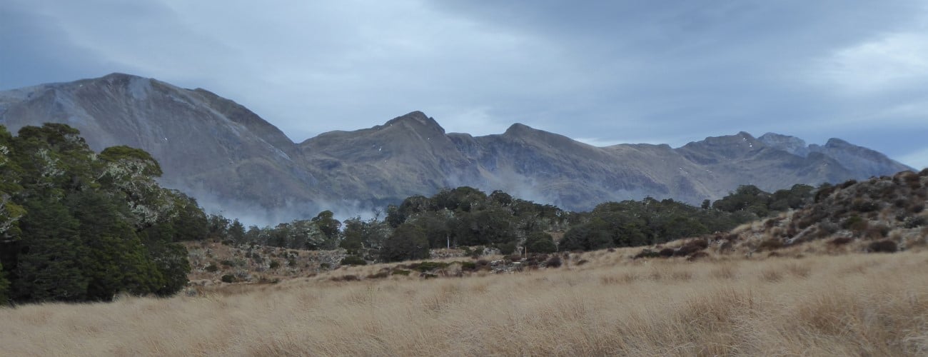
The Tableland is a fascinating alpine plateau of rolling tussock and karst features, located west of Mt Arthur, in Kahurangi National Park. Beginning at Flora car park, Flora-Salisbury Track gives access to the Tableland and Salisbury Lodge, passing beautiful beech forest and unusual rock shelters along the way. Salisbury Lodge is a popular destination for overnight trips, as well as multi-day trips to Cobb Valley, Leslie-Karamea Track and Upper Takaka.
| Details | |
| Length | 13.9 km one way Flora car park to Salisbury Lodge |
| Time Required | 4-5 hr one way Flora car park to Salisbury Lodge |
| Trail Type | 4WD road/Tramping track |
| Physical Difficulty | Moderate |
| Uses | Walking and trail running |
| Direction | Either |
| Start Elevation | 930 m (Flora car park) |
| Finish Elevation | 1130 m (Salisbury Lodge) |
| Dog Access | Dogs are prohibited in Kahurangi National Park |
1 hr 15 min from Nelson
Flora car park is the starting point for the Tableland Circuit, as well as Mt Arthur Track, Lodestone Circuit and multi-day tramps to places further afield, such as Cobb Valley and the Leslie-Karamea Track. It is located 10 km up Graham Valley Road at 930 m elevation. Graham Valley Road begins off Motueka River West Bank Road near Ngatimoti, and is approximately 65 km from Nelson and 21 km from Motueka. Be aware that the road is steep, narrow and unsealed, and can be icy in winter. A 4WD vehicle is recommended. It is also prone to slips, so check the DOC or TDC websites for road access updates.
At the car park there is a toilet, and a shelter named Flora Kiosk, where you can view maps and track information, and enter your intentions in the logbook.
From Flora car park, Flora-Salisbury Track begins as a 4WD track, climbing gently to Flora Saddle, and then descending through beech forest on the western side of the saddle to Flora Hut. You will notice the predator traps along the side of the track; these are maintained by Friends of Flora, who have been running a trapping and monitoring programme for nearly two decades. Whio are now re-populating Flora Stream, which babbles quietly in the gully on the right side of the track. You’ll reach Flora Hut after 30 min. The hut is located in a large, grassy clearing. Its design is somewhat distinctive among backcountry huts, as it is actually two conjoined huts with a firewood bay in the middle. There are picnic tables out the front and plenty of room to pitch tents.
Beyond Flora Hut, the 4WD track is undulating though overall descending as it heads down the valley. Cloustons Mine Track (which connects to Gordons Pyramid Route) forks to the left 1 hour (3.9 km) after Flora Hut. The track passes beneath an archway reading ‘Gridiron Gulch’, and reaches Upper Gridiron Hut. The hut, which is up a steep zig-zag track on left side of the track, utilises a rock overhang for part of its roof. Lower Gridiron Shelter is 100 m further on; the rock shelter is composed of an open fire, table and sleeping platform beneath a massive rounded rock jutting out of the hill. A swingbridge crosses Gridiron Creek and the 4WD road narrows to a tramping track.
| Upper Gridiron Hut | |
| Hut Type | Standard Hut |
| Capacity | 3 bunks |
| Bookings | Not required; first in, first served |
| Fee | 1 Standard Hut Ticket |
| Altitude | 830 m |
Beyond Gridiron you’ll pass some beautiful pools in Flora Stream that are great for cooling off in summer (if you can stand the sandflies). You’ll reach Upper Junction 25 min after Lower Gridiron Shelter; here you can take the right fork onto Upper Takaka Track, which follows the beginnings of Takaka River and leads to Cobb Valley Road via Asbestos Cottage (1 hr 30 min, 5.3 km away), and to Upper Takaka Valley via Barron Flat. Take the left fork to continue toward Salisbury Lodge (the track from here is called Salisbury Track) as it turns southwest, now climbing a little and travelling high above the true right of Balloon Creek. Growler Rock Shelter is 15 min after Upper Junction. The track continues for 45 min (2.2 km) before the trees open up to tussock as you reach the northern end of the Tableland.
After a few hundred metres in the tussock a short deviation to the left will take you to Dry Rock Shelter (basic shelter, sleeping platform with four mattresses) and 600 m further Starvation Ridge Track forks to the right (take this if you’re heading straight to Balloon Hut). Salisbury Track continues along the gently undulating Tableland to Salisbury Lodge. Note the track through the tussock is deeply rutted and can be very muddy.
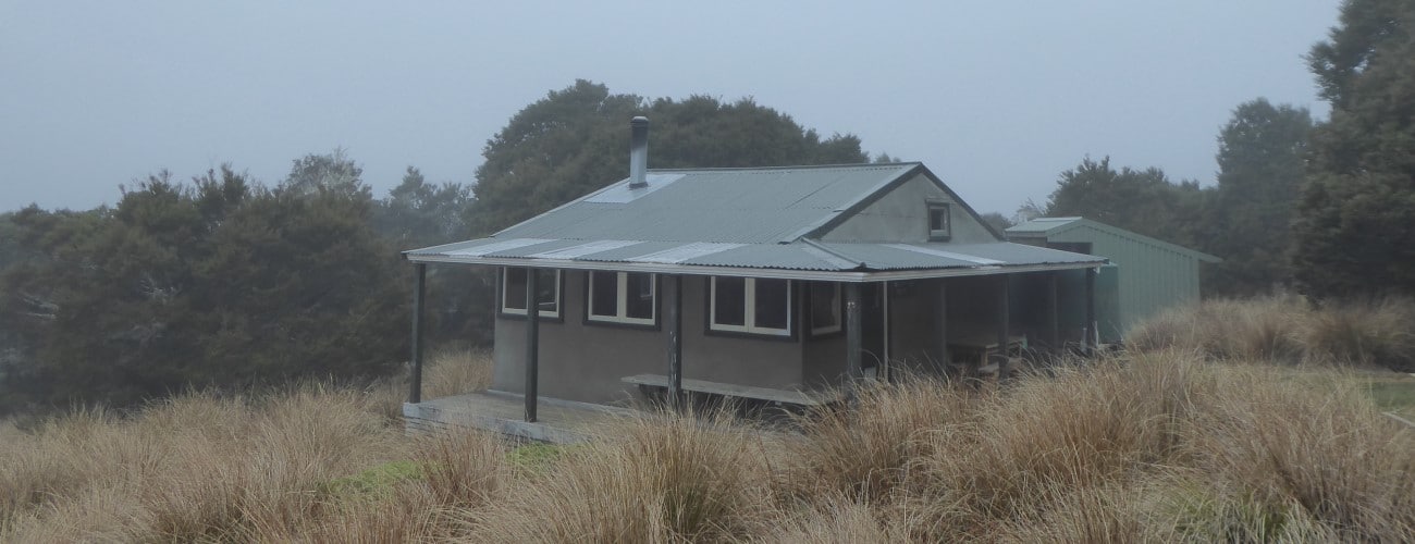
Salisbury Lodge is situated in an elevated position on the edge of the tussock. Large windows give expansive views east to Gordon’s Pyramid and Mt Arthur. The serviced hut has 22 bunks and has an indoor basin. There are even solar-powered lights in the toilets behind the hut. The hut is named after Thomas Salisbury, who in 1863 was the first European settler to discover the Tableland. His brother John Salisbury grazed sheep on the Tableland in 1875.
| Salisbury Lodge | |
| Hut Type | Serviced Hut |
| Capacity | 22 bunks |
| Bookings | Not required; first in, first served |
| Fee | 1 Serviced Hut Ticket |
| Altitude | 1130 m |
Potholes Walk is a 2.5 km (1 hr) loop track beginning at Salisbury Lodge, that takes in Sphinx Valley Cave and karst depressions east of the hut. The ‘sphinx’ was a limestone outcrop upstream of the cave entrance, so named due to the mythical creature it was thought to resemble. Unfortunately the sphinx collapsed in the 1929 Murchison Earthquake. The track skirts around steep-sided depressions and connects with Gordon’s Pyramid Route, not far from the junction with Salisbury Track.
Be sure to record your intentions in the visitor book at Flora car park and at huts you pass along the way. The Tableland is an alpine environment. The lowest elevation the track reaches is 800 m at Upper Junction. Make sure you prepare accordingly, even in summer, as freezing alpine conditions can occur at any time of year. Deep snow may lay for weeks through the cold months and spring snow is not uncommon. Do not rely on the weather forecast for the nearest town Motueka, as the alpine weather is likely to be drastically different. Sturdy outdoor footwear is recommended. The Tableland is a karst landscape with many unknown caves and sinkholes. Do not deviate from the track, particularly on the Potholes Track.
See the Mountain Safety Council website for useful information on preparing for the outdoors.


The Tableland is a fascinating alpine plateau of rolling tussock and karst features, located west of Mt Arthur, in Kahurangi National Park. Beginning at Flora car park, Flora-Salisbury Track gives access to the Tableland and Salisbury Lodge, passing beautiful beech forest and unusual rock shelters along the way. Salisbury Lodge is a popular destination for overnight trips, as well as multi-day trips to Cobb Valley, Leslie-Karamea Track and Upper Takaka.
| Details | |
| Length | 13.9 km one way Flora car park to Salisbury Lodge |
| Time Required | 4-5 hr one way Flora car park to Salisbury Lodge |
| Trail Type | 4WD road/Tramping track |
| Physical Difficulty | Moderate |
| Uses | Walking and trail running |
| Direction | Either |
| Start Elevation | 930 m (Flora car park) |
| Finish Elevation | 1130 m (Salisbury Lodge) |
| Dog Access | Dogs are prohibited in Kahurangi National Park |
1 hr 15 min from Nelson
Flora car park is the starting point for the Tableland Circuit, as well as Mt Arthur Track, Lodestone Circuit and multi-day tramps to places further afield, such as Cobb Valley and the Leslie-Karamea Track. It is located 10 km up Graham Valley Road at 930 m elevation. Graham Valley Road begins off Motueka River West Bank Road near Ngatimoti, and is approximately 65 km from Nelson and 21 km from Motueka. Be aware that the road is steep, narrow and unsealed, and can be icy in winter. A 4WD vehicle is recommended. It is also prone to slips, so check the DOC or TDC websites for road access updates.
At the car park there is a toilet, and a shelter named Flora Kiosk, where you can view maps and track information, and enter your intentions in the logbook.
From Flora car park, Flora-Salisbury Track begins as a 4WD track, climbing gently to Flora Saddle, and then descending through beech forest on the western side of the saddle to Flora Hut. You will notice the predator traps along the side of the track; these are maintained by Friends of Flora, who have been running a trapping and monitoring programme for nearly two decades. Whio are now re-populating Flora Stream, which babbles quietly in the gully on the right side of the track. You’ll reach Flora Hut after 30 min. The hut is located in a large, grassy clearing. Its design is somewhat distinctive among backcountry huts, as it is actually two conjoined huts with a firewood bay in the middle. There are picnic tables out the front and plenty of room to pitch tents.
Beyond Flora Hut, the 4WD track is undulating though overall descending as it heads down the valley. Cloustons Mine Track (which connects to Gordons Pyramid Route) forks to the left 1 hour (3.9 km) after Flora Hut. The track passes beneath an archway reading ‘Gridiron Gulch’, and reaches Upper Gridiron Hut. The hut, which is up a steep zig-zag track on left side of the track, utilises a rock overhang for part of its roof. Lower Gridiron Shelter is 100 m further on; the rock shelter is composed of an open fire, table and sleeping platform beneath a massive rounded rock jutting out of the hill. A swingbridge crosses Gridiron Creek and the 4WD road narrows to a tramping track.
| Upper Gridiron Hut | |
| Hut Type | Standard Hut |
| Capacity | 3 bunks |
| Bookings | Not required; first in, first served |
| Fee | 1 Standard Hut Ticket |
| Altitude | 830 m |
Beyond Gridiron you’ll pass some beautiful pools in Flora Stream that are great for cooling off in summer (if you can stand the sandflies). You’ll reach Upper Junction 25 min after Lower Gridiron Shelter; here you can take the right fork onto Upper Takaka Track, which follows the beginnings of Takaka River and leads to Cobb Valley Road via Asbestos Cottage (1 hr 30 min, 5.3 km away), and to Upper Takaka Valley via Barron Flat. Take the left fork to continue toward Salisbury Lodge (the track from here is called Salisbury Track) as it turns southwest, now climbing a little and travelling high above the true right of Balloon Creek. Growler Rock Shelter is 15 min after Upper Junction. The track continues for 45 min (2.2 km) before the trees open up to tussock as you reach the northern end of the Tableland.
After a few hundred metres in the tussock a short deviation to the left will take you to Dry Rock Shelter (basic shelter, sleeping platform with four mattresses) and 600 m further Starvation Ridge Track forks to the right (take this if you’re heading straight to Balloon Hut). Salisbury Track continues along the gently undulating Tableland to Salisbury Lodge. Note the track through the tussock is deeply rutted and can be very muddy.
Salisbury Lodge is situated in an elevated position on the edge of the tussock. Large windows give expansive views east to Gordon’s Pyramid and Mt Arthur. The serviced hut has 22 bunks and has an indoor basin. There are even solar-powered lights in the toilets behind the hut. The hut is named after Thomas Salisbury, who in 1863 was the first European settler to discover the Tableland. His brother John Salisbury grazed sheep on the Tableland in 1875.
| Salisbury Lodge | |
| Hut Type | Serviced Hut |
| Capacity | 22 bunks |
| Bookings | Not required; first in, first served |
| Fee | 1 Serviced Hut Ticket |
| Altitude | 1130 m |
Potholes Walk is a 2.5 km (1 hr) loop track beginning at Salisbury Lodge, that takes in Sphinx Valley Cave and karst depressions east of the hut. The ‘sphinx’ was a limestone outcrop upstream of the cave entrance, so named due to the mythical creature it was thought to resemble. Unfortunately the sphinx collapsed in the 1929 Murchison Earthquake. The track skirts around steep-sided depressions and connects with Gordon’s Pyramid Route, not far from the junction with Salisbury Track.
Be sure to record your intentions in the visitor book at Flora car park and at huts you pass along the way. The Tableland is an alpine environment. The lowest elevation the track reaches is 800 m at Upper Junction. Make sure you prepare accordingly, even in summer, as freezing alpine conditions can occur at any time of year. Deep snow may lay for weeks through the cold months and spring snow is not uncommon. Do not rely on the weather forecast for the nearest town Motueka, as the alpine weather is likely to be drastically different. Sturdy outdoor footwear is recommended. The Tableland is a karst landscape with many unknown caves and sinkholes. Do not deviate from the track, particularly on the Potholes Track.
See the Mountain Safety Council website for useful information on preparing for the outdoors.
The track between Salisbury Lodge and Balloon Hut traverses an area of the Tableland rich in pioneering history. The distance between the two huts is not far, which allows plenty of time to explore the tussock downs and historic gold workings, and enjoy the stunning views of the Arthur Range.
| Details | |
| Length | 4.1 km Salisbury Lodge to Balloon Hut; 8.4 km Balloon Hut to Cobb Valley Rd via Lake Peel Track; 18 km Flora car park to Balloon Hut |
| Time Required | 1 hr 30 min Salisbury Lodge to Balloon Hut; 3-4 hr Cobb Valley Rd to Balloon Hut (Lake Peel Track) |
| Trail Type | Tramping track |
| Physical Difficulty | Moderate |
| Uses | Walking and trail running |
| Direction | Either |
| Start Elevation | 1130 m (Salisbury Lodge) |
| Finish Elevation | 1260 m (Balloon Hut) |
| Dog Access | Dogs are prohibited in Kahurangi National Park |
1 hr 15 min from Nelson (Flora car park) | 2 hr from Nelson (Cobb Reservoir)
Balloon Hut can be accessed from Flora car park or Cobb Valley.
If you’re going straight from Flora car park to Balloon Hut, you can bypass Salisbury Lodge by taking Starvation Ridge Track (you will see the signpost indicating the turnoff).
To get to Cobb Valley from Nelson, head west along State Highway 60. After you’ve driven over Takaka Hill, turn left at Upper Takaka onto Cobb Dam Road, and follow it as it winds up Cobb Valley and climbs over a ridge to reach Cobb Reservoir. The road is very narrow and has steep drop-offs to Cobb River below, so you must drive with extreme caution. Follow the road the whole way along the reservoir and park in the small grassed car park on the left (signpost reads Lake Peel Track). Note that the majority of Cobb Dam Road is unsealed. The road is quite narrow so be wary of oncoming vehicles.
From Salisbury Lodge, Salisbury Track climbs gently westward through amazing stunted mountain beech. After 700 m the track reconnects with Starvation Ridge Track, and a few hundred metres later the beech trees give way to a large expanse of tussock. Halfway across this open is the junction with Leslie-Karamea Track.
The track drops down into the upper reaches of Cundy Creek, where you will reach a natural karst amphitheater known as ‘The Clearing’. The track climbs out of the gully and follows a corridor of tussock through beech forest just east of Balloon Hill, reaching Balloon Hut soon after.
Balloon Hut is nestled against the treeline at 1260 m elevation. There are no grand views from the hut itself, though the beech forest and tussock outlook is very nice. There are plenty of weka around and you will hear likely morepork at night. The current edition of the hut has been in place since a refurbishment in 1995. A framed picture on the wall shows the history of the hut, right back to when it was first constructed in 1909.
| Balloon Hut | |
| Hut Type | Serviced Hut |
| Capacity | 14 bunks |
| Bookings | Not required; first in, first served |
| Fee | 1 Serviced Hut Ticket |
| Facilities | Woodburner, mattresses, space for a few tents outside |
| Altitude | 1260 m |
Lake Peel Track continues from Balloon Hut toward Lake Peel, Myttons Hut and Cobb Valley Rd. From Balloon Hut it is 8.4 km (3-4 hr) to Cobb Valley Rd via Lake Peel and Myttons Hut.


The track between Salisbury Lodge and Balloon Hut traverses an area of the Tableland rich in pioneering history. The distance between the two huts is not far, which allows plenty of time to explore the tussock downs and historic gold workings, and enjoy the stunning views of the Arthur Range.
| Details | |
| Length | 4.1 km Salisbury Lodge to Balloon Hut; 8.4 km Balloon Hut to Cobb Valley Rd via Lake Peel Track; 18 km Flora car park to Balloon Hut |
| Time Required | 1 hr 30 min Salisbury Lodge to Balloon Hut; 3-4 hr Cobb Valley Rd to Balloon Hut (Lake Peel Track) |
| Trail Type | Tramping track |
| Physical Difficulty | Moderate |
| Uses | Walking and trail running |
| Direction | Either |
| Start Elevation | 1130 m (Salisbury Lodge) |
| Finish Elevation | 1260 m (Balloon Hut) |
| Dog Access | Dogs are prohibited in Kahurangi National Park |
1 hr 15 min from Nelson (Flora car park) | 2 hr from Nelson (Cobb Reservoir)
Balloon Hut can be accessed from Flora car park or Cobb Valley.
If you are going straight from Flora car park to Balloon Hut, you can bypass Salisbury Lodge by taking the Starvation Ridge Track (you will see the signpost indicating this).
To get to Cobb Valley from Nelson, head west along State Highway 60. After you’ve driven over Takaka Hill, turn left at Upper Takaka onto Cobb Dam Road, and follow it as it winds up Cobb Valley and climbs over a ridge to reach Cobb Reservoir. The road is very narrow and has steep drop-offs to Cobb River below, so you must drive with extreme caution. Follow the road the whole way along the reservoir and park in the small grassed car park on the left (signpost reads Lake Peel Track). Note that the majority of Cobb Dam Road is unsealed. The road is quite narrow so be wary of oncoming vehicles.
From Salisbury Lodge, Salisbury Track climbs gently westward through amazing stunted mountain beech. After 700 m the track reconnects with Starvation Ridge Track, and a few hundred metres later the beech trees give way to a large expanse of tussock. Halfway across this open is the junction with Leslie-Karamea Track.
The track drops down into the upper reaches of Cundy Creek, where you will reach a natural karst amphitheater known as ‘The Clearing’ near the head of Cundy Creek. The track climbs out of the gully and follows a corridor of tussock through beech forest just east of Balloon Hill, reaching Balloon Hut soon after.
Balloon Hut is nestled against the treeline at 1260 m elevation. There are no grand views from the hut itself, though the beech and tussock outlook is very nice. There are plenty of weka around and you will hear likely morepork at night. The current edition of the hut has been in place since a refurbishment in 1995. A framed picture on the wall shows the history of the hut, right back to when it was first constructed in 1909.
| Balloon Hut | |
| Hut Type | Serviced Hut |
| Capacity | 14 bunks |
| Bookings | Not required; first in, first served |
| Fee | 1 Serviced Hut Ticket |
| Facilities | Woodburner, mattresses, space for a few tents outside |
| Altitude | 1260 m |
Lake Peel Track continues from Balloon Hut toward Lake Peel, Myttons Hut and Cobb Valley Rd. From Balloon Hut it is 8.4 km (3-4 hr) to Cobb Valley Rd via Lake Peel and Myttons Hut.
Be sure to record your intentions in the visitor book at Flora car park and at huts you pass along the way. The Tableland is an alpine environment. Make sure you prepare accordingly, even in summer, as freezing alpine conditions can occur at any time of year. Deep snow may lay for weeks through the cold months and spring snow is not uncommon. Do not rely on the weather forecast for the nearest town Motueka, as the alpine weather is likely to be drastically different. Sturdy outdoor footwear is recommended.
Updated 9 February 2022