Saddle Hill, also known as The Doubles, is the collective name for a pair of forested hills on the Bryant Range, east of central Nelson. The two peaks, 2.2 km distinct from each other, are 1217 m and 1168 m in elevation respectively, and are the two highest within close distance of central Nelson. Relative to popular tracks nearby, they receive very few visitors and provide challenging day walk.
| Details | |
| Distances | 6.7 km caretakers house to Maungatapu Saddle; 1.9 km Maungatapu Saddle to South Double; 4.3 km return South Double to North Double; 7 km South Double to caretakers house via Zig Zag Track and Teal Saddle |
| Time Required | 2-3 hr caretakers house to Maungatapu Saddle; 1 hr Maungatapu Saddle to South Double; 2 hr return South Double to North Double; 2-3 hr South Double to caretakers house via Zig Zag Track and Teal Saddle |
| Trail Type | Tramping track/Route |
| Physical Difficulty | Hard |
| Uses | Walking |
| Start Elevation | 230 m (caretakers house) or 750 m (Maungatapu Saddle) |
| Max Elevation | 1168 m or 1217 m |
If any layers fail to load, try clearing your cache and refreshing the page.
20 min from central Nelson (Maitai Dam)
The easiest place to climb Saddle Hill from is Maungatapu Track at Maungatapu Saddle. However, Maungatapu Track is open to public 4WD vehicles on the Pelorus side only.
On the Nelson side, you can begin at the Maitai Dam car park. Alternatively, you can save yourself 110 m of climbing and park next to the locked gate across Maungatapu Track, next to the Maitai Dam caretaker’s house.
The only track maintained by DOC extends from Maungatapu Saddle to the summit of the South Double. The route between South Double and North Double, along with Zig-Zag Track (between Teal Saddle and South Double) and the route between Top Road and North Double are all ‘route’ grade and are marked but not maintained.
Beginning at the caretakers house, pass the locked gate and follow Maungatapu Track as it descends around the side of Maitai Dam and climbs Bryant Range to Maungatapu Saddle (750 m elevation).
On the northern side of the saddle, follow the 4WD road that climbs steeply up to a transmission tower. Beyond here, the track enters beech forest, dropping into saddle before beginning the ascent up South Double. The track heads in a more-or-less straight line at a consistently steep gradient. As you gain elevation the forest gradually transitions to pure silver beech draped in moss, with almost no undergrowth. Above 1000 m elevation, the topography begins to level off, to the point where the summit of South Double (1168 m) is completely flat. Here there is a track junction with the route to North Double, and Zig Zag Track which drops down to Teal Saddle.
To head to the North Double (the true geographic ‘Saddle Hill’), head north at the junction. The route, often vague, is marked by orange triangles, but the relatively gentle topography and open silver beech forest make it easy to pick your way through. The track drops down past a spine of blocky rock into the saddle between the two summits, where there is a small muddy pond. From here the route climbs at a steady gradient to the summit of North Double.
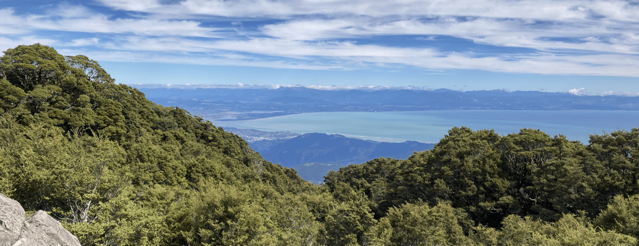
The summit features a stony clearing, transmission tower and small building. The trig is positioned on a rocky outcrop, atop which you will have some views to the west and east, with Nelson City visible below. A sign indicates the beginning of an old route that descends straight down the side of the range to Top Road, in Hira Forest. This route gets very little use and its condition is unknown.
Return the way you came to South Double. Once there, you have the option of descending the way you came up from Maungatapu Saddle, or taking Zig Zag Track (route grade) to Teal Saddle.
As its name suggests, Zig Zag Track zig-zags irregularly down the western side of South Double. This route also gets very little use, and though it is marked with orange triangles and occasional tape, in places it is very vague and difficult to follow. Once at the bottom, it connects with the upper end of Zig Zag Road, a forestry road. Follow Zig Zag Road as it winds down to connect with Central Road. Turn left onto Central Rd, head to Teal Saddle and descend down to the caretakers house to complete the circuit.


Saddle Hill, also known as The Doubles, is the collective name for a pair of forested hills on the Bryant Range, east of central Nelson. The two peaks, 2.2 km distinct from each other, are 1217 m and 1168 m in elevation respectively, and are the two highest within close distance of central Nelson. Relative to popular tracks nearby, they receive very few visitors, yet they provide challenging day walk.
| Details | |
| Distances | 6.7 km caretakers house to Maungatapu Saddle; 1.9 km Maungatapu Saddle to South Double; 4.3 km return South Double to North Double; 7 km South Double to caretakers house via Zig Zag Track and Teal Saddle |
| Time Required | 2-3 hr caretakers house to Maungatapu Saddle; 1 hr Maungatapu Saddle to South Double; 2 hr return South Double to North Double; 2-3 hr South Double to caretakers house via Zig Zag Track and Teal Saddle |
| Trail Type | Tramping track/Route |
| Physical Difficulty | Hard |
| Uses | Walking |
| Start Elevation | 230 m (caretakers house) or 750 m (Maungatapu Saddle) |
| Max Elevation | 1168 m or 1217 m |
20 min from central Nelson (Maitai Dam)
The easiest place to climb Saddle Hill from is Maungatapu Track at Maungatapu Saddle. However, Maungatapu Track is open to public 4WD vehicles on the Pelorus side only.
On the Nelson side, you can begin at the Maitai Dam car park. Alternatively, you can save yourself 110 m of climbing and park next to the locked gate across Maungatapu Track, next to the Maitai Dam caretaker’s house.
The only track maintained by DOC extends from Maungatapu Saddle to the summit of the South Double. The route between South Double and North Double, along with Zig-Zag Track (between Teal Saddle and South Double) and the route between Top Road and North Double are all ‘route’ grade and are marked but not maintained.
Beginning at the caretakers house, pass the locked gate and follow Maungatapu Track as it descends around the side of Maitai Dam and climbs Bryant Range to Maungatapu Saddle (750 m elevation).
On the northern side of the saddle, follow the 4WD road that climbs steeply up to a transmission tower. Beyond here, the track enters beech forest, dropping into saddle before beginning the ascent up South Double. The track heads in a more-or-less straight line at a consistently steep gradient. As you gain elevation the forest gradually transitions to pure silver beech draped in moss, with almost no undergrowth. Above 1000 m elevation, the topography begins to level off, to the point where the summit of South Double (1168 m) is completely flat. Here there is a track junction with the route to North Double, and Zig Zag Track which drops down to Teal Saddle.
To head to the North Double (the true geographic ‘Saddle Hill’), head north at the junction. The route, often vague, is marked by orange triangles, but the relatively gentle topography and open silver beech forest make it easy to pick your way through. The track drops down past a spine of blocky rock into the saddle between the two summits, where there is a small muddy pond. From here the route climbs at a steady gradient to the summit of North Double.
The summit features a stony clearing, transmission tower and small building. The trig is positioned on a rocky outcrop, atop which you will have some views to the west and east, with Nelson City visible below. A sign indicates the beginning of an old route that descends straight down the side of the range to Top Road, in Hira Forest. This route gets very little use and its condition is unknown
Return the way you came to South Double. Once there, you have the option of descending the way you came up from Maungatapu Saddle, or taking Zig Zag Track (route grade) to Teal Saddle.
As its name suggests, Zig Zag Track zig-zags irregularly down the western side of South Double. This route also gets very little use, and though it is marked with orange triangles and occasional tape, in places it is very vague and difficult to follow. Once at the bottom, it connects with the upper end of Zig Zag Road, a forestry road. Follow Zig Zag Road as it winds down to connect with Central Road. Turn left onto Central Rd, head to Teal Saddle and descend down to the caretakers house to complete the circuit.