Mt Patriarch (1656 m) is a peak overlooking Wairau Valley in Mt Richmond Forest Park. The route to the summit is challenging, though a 4WD forestry road provides foot and MTB access to within short distance of it.
| Details | |
| Length | 17 km return (from DOC route start) |
| Time Required | 6-7 hr return (walking, from DOC route start) |
| Trail Type | 4WD road/Route |
| Physical Difficulty | Hard (from DOC route start) |
| Uses | Walking, trail running and MTB |
| Direction | Return (up and down) |
| Start Elevation | 1200 m |
| Max Elevation | 1656 m |
| Dog Access | Permit required for Mt Richmond Forest Park; see local DOC office |
If any layers fail to load, try clearing your cache and refreshing the page.
Lake Chalice
Walking
Mid Goulter Route
Walking
3 hr from Nelson | 2 hr from Blenheim
From Nelson, head east along State Highway 6 all the way into Marlborough. Turn right onto Northbank Rd, which is just before the Wairau River bridge. Follow Northbank Rd for 33 km to the right-hand turnoff to Top Valley. Head up Top Valley and follow the DOC signs that indicate the way to Mt Patriarch and Lake Chalice. Staircase Rd winds up the valley side through pine forest for 8.7 km to the Mt Richmond Forest Park boundary, then sidles the valley to Staircase Saddle. Lake Chalice car park is on the right side of the road, though continue for a further 7 km along the range until you reach the grassed parking area just before the DOC sign reading ‘Mt Patriarch Route’ (1200 m elevation). Beyond here the 4WD road is rougher; though you can drive beyond the sign right to the road end (1440 m elevation), doing so is not recommended.
If you’re riding, you can park at Lake Chalice car park for some extra distance. You can even start from the Top Valley floor and ride up Staircase Rd.
Logging and high fire risk will close access.
From the car park, the road continues along the range, climbing gently into the Goulter Valley side and allowing good views of Lake Chalice. The track to Mid Goulter Hut (3 hr away) branches from here. The bulk of Mt Patriarch comes into view further along the range, and the road sidles over a scree slope and descends gradually to the Wairau Valley side of the ridge. The surrounding vegetation is dominated by a mix of exotic conifers, which give the landscape a North American alpine feel. The road steepens and climbs through a couple of zig-zags to 1440 m elevation. This marks the end of the 4WD road, and the beginning of the route. Riding is impossible beyond here, so you will have to leave you bike and continue on foot.
The route traverses the narrow, craggy ridge. This requires sure-footedness and is probably not suitable for those who do not have a head for heights. The route drops off the top of the ridge and onto the Goulter side, where it sidles beneath precarious bluffs and across active rock slides that drop very steeply to the valley far below. Proceed along this section with extreme caution, especially when visibility is poor and the route is not always obvious.
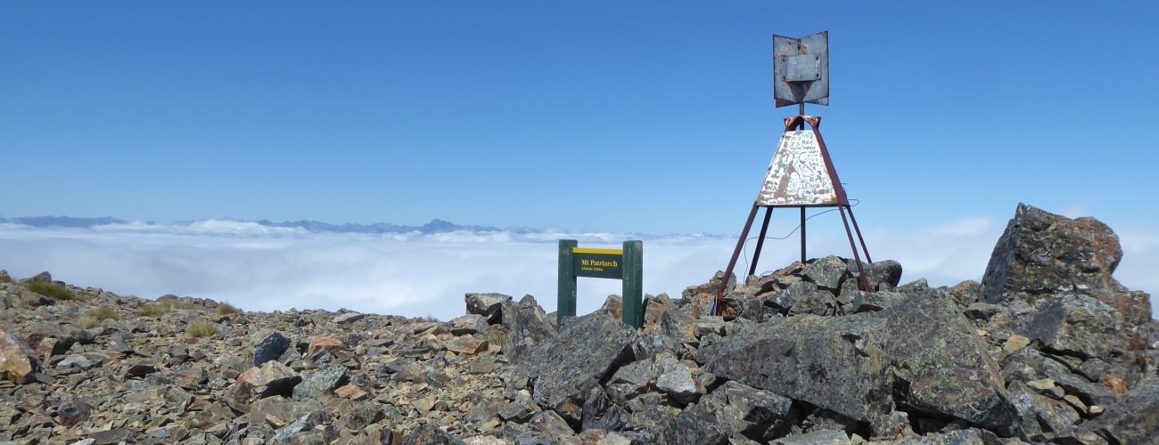
The slope eases and the route climbs to a barren, rock-strewn saddle. Follow the poles for the remaining climb up to the summit, which is marked by a trig and a DOC sign. At the summit, enjoy the expansive views of Wairau Valley, the mountains of Inland Marlborough, and the rugged peaks of the Richmond Ranges.
Return the way you came.
Mt Patriarch is an alpine environment, so proper preparation and care should be made to ensure a safe trip. The route reaches a high elevation and is very exposed, so proper outdoor clothing is essential. You must always be prepared for freezing conditions and take extreme care if snow and ice and are present. Do not rely on the Blenheim weather forecast as the alpine conditions in Mt Richmond Forest Park are likely to be drastically different. The route beyond the 4WD road is physically challenging and in places is difficult to follow. There are no water sources along the way, so make sure you carry plenty of your own.
See the Mountain Safety Council website for useful information on preparing for the outdoors.


Mt Patriarch (1656 m) is a peak overlooking Wairau Valley in Mt Richmond Forest Park. The route to the summit is challenging, though a 4WD forestry road provides foot and MTB access to within short distance of it.
| Details | |
| Length | 17 km return (from DOC route start) |
| Time Required | 6-7 hr return (walking, from DOC route start) |
| Trail Type | 4WD road/Route |
| Physical Difficulty | Hard (from DOC route start) |
| Uses | Walking, trail running and MTB |
| Direction | Return (up and down) |
| Start Elevation | 1200 m |
| Max Elevation | 1656 m |
| Dog Access | Permit required for Mt Richmond Forest Park; see local DOC office |
3 hr from Nelson | 2 hr from Blenheim
From Nelson, head east along State Highway 6 all the way into Marlborough. Turn right onto Northbank Rd, which is just before the Wairau River bridge. Follow Northbank Rd for 33 km to the right-hand turnoff to Top Valley. Head up Top Valley and follow the DOC signs that indicate the way to Mt Patriarch and Lake Chalice. Staircase Rd winds up the valley side through pine forest for 8.7 km to the Mt Richmond Forest Park boundary, then sidles the valley to Staircase Saddle. Lake Chalice car park is on the right side of the road, though continue for a further 7 km along the range until you reach the grassed parking area just before the DOC sign reading ‘Mt Patriarch Route’ (1200 m elevation). Beyond here the 4WD road is rougher; though you can drive beyond the sign right to the road end (1440 m elevation), doing so is not recommended.
If you’re riding, you can park at Lake Chalice car park for some extra distance. You can even start from the Top Valley floor and ride up Staircase Rd.
Logging and high fire risk will close access.
From the car park, the road continues along the range, climbing gently into the Goulter Valley side and allowing good views of Lake Chalice. The track to Mid Goulter Hut (3 hr away) branches from here. The bulk of Mt Patriarch comes into view further along the range, and the road sidles over a scree slope and descends gradually to the Wairau Valley side of the ridge. The surrounding vegetation is dominated by a mix of exotic conifers, which give the landscape a North American alpine feel. The road steepens and climbs through a couple of zig-zags to 1440 m elevation. This marks the end of the 4WD road, and the beginning of the route. Riding is impossible beyond here, so you will have to leave you bike and continue on foot.
The route traverses the narrow, craggy ridge. This requires sure-footedness and is probably not suitable for those who do not have a head for heights. The route drops off the top of the ridge and onto the Goulter side, where it sidles beneath precarious bluffs and across active rock slides that drop very steeply to the valley far below. Proceed along this section with extreme caution, especially when visibility is poor and the route is not obvious.
The slope eases and the route climbs to a barren, rock-strewn saddle. Follow the poles for the remaining climb up to the summit, which is marked by a trig and a DOC sign. At the summit, enjoy the expansive views of Wairau Valley, the mountains of Inland Marlborough, and the rugged peaks of the Richmond Ranges.
Return the way you came.
Mt Patriarch is an alpine environment, so proper preparation and care should be made to ensure a safe trip. The route reaches a high elevation and is very exposed, so proper outdoor clothing is essential. You must always be prepared for freezing conditions and take extreme care if snow and ice and are present. Do not rely on the Blenheim weather forecast as the alpine conditions in Mt Richmond Forest Park are likely to be drastically different. The route beyond the 4WD road is physically challenging and in places is difficult to follow. There are no water sources along the way, so make sure you carry plenty of your own.
See the Mountain Safety Council website for useful information on preparing for the outdoors.
Lake Chalice
Walking
Mid Goulter Route
Walking
Updated 1 January 2020