Travers Peak is a peak on the Libretto Range, just south of Lewis Pass. Foley’s Track leads from State Highway 7 to the tree line, and from there the open tops can be easily traversed to reach the 1724 m summit.
| Details | |
| Length | 8.2 km return |
| Time Required | 3-4 hr return |
| Trail Type | Tramping track/unmarked route |
| Physical Difficulty | Hard |
| Uses | Walking |
| Start Elevation | 780 m |
| Max Elevation | 1724 m |
If any layers fail to load, try clearing your cache and refreshing the page.
Foley’s Track does not connect to any other official tracks.
20 min from Springs Junction
Foley’s Track begins directly across the road from the entrance to the Deer Valley camping area. From Springs Junction, head east along State Highway 7 and over Lewis Pass. Deer Valley camping area is on the right side of the highway (if heading south), 2 min south of the St James Track parking area immediately after Lewis Pass.
Foley’s Track begins on the side of SH7, immediately opposite Deer Valley car park. The track briefly runs parallel to the highway, before turning uphill. The track heads upward in a more-or-less straight line along the crest of a spur through mountain beech forest, and steepens as you gain elevation towards the tree line (1300 m).
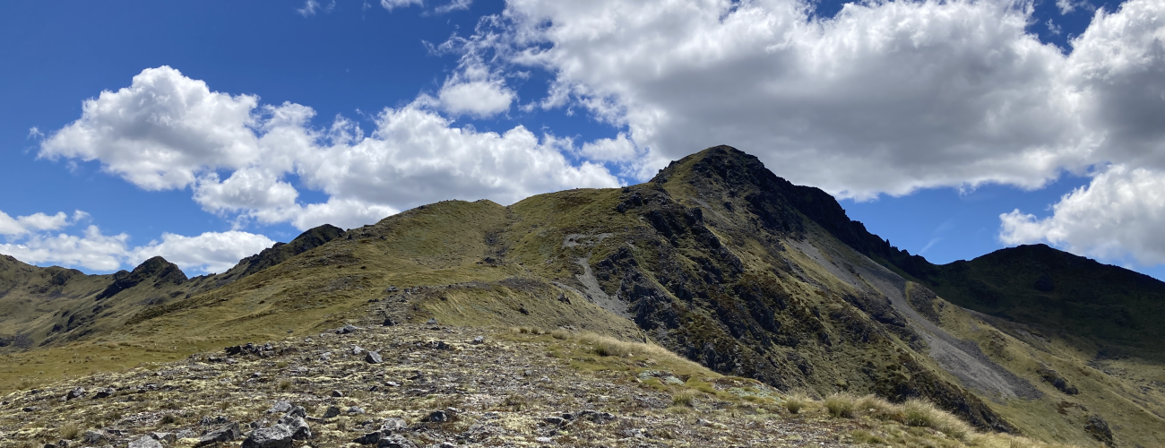
Above the tree line, the travel is easy-going through snow tussock and low alpine shrubs. There are only a couple of sporadic marker poles to lead the way, though in clear conditions the direction required is reasonably obvious. There is an initial steep climb soon after the tree line, and afterward the ridge gradient eases and the summit comes into sight. The ridge, which features hollows, boulder sections and a few very small tarns, narrows and steepens towards the summit, and the last climb involves a little bit of loose scree. There are no marker poles here, though in snow-free conditions there is a lightly-worn route.
The prominence of the summit allows spectacular views of the peaks and valleys of the surrounding Lewis Pass area. The nearby peak of Trovatore is recognisable to the north with its antennae, and Mt Technical stands out immediately west across the Lewis Valley.
Return the way you came.
The open tops of the Libretto Range are an alpine environment, so proper preparation and care should be made to ensure a safe trip. The track reaches a high elevation and is exposed above the tree line, so proper outdoor clothing is essential. You must always be prepared for freezing conditions and take extreme care if snow and ice and are present. Make sure you carry plenty of water with you as there are no water sources on the way up.
See the Mountain Safety Council website for useful information on preparing for the outdoors.


Travers Peak is a peak on the Libretto Range, just south of Lewis Pass. Foley’s Track leads from State Highway 7 to the tree line, and from there the open tops can be easily traversed to reach the 1724 m summit.
| Details | |
| Length | 8.2 km return |
| Time Required | 3-4 hr return |
| Trail Type | Tramping track/unmarked route |
| Physical Difficulty | Hard |
| Uses | Walking |
| Start Elevation | 780 m |
| Max Elevation | 1724 m |
20 min from Springs Junction
Foley’s Track begins directly across the road from the entrance to the Deer Valley camping area. From Springs Junction, head east along State Highway 7 and over Lewis Pass. Deer Valley camping area is on the right side of the highway (if heading south), 2 min south of the St James Track parking area immediately after Lewis Pass.
Foley’s Track begins on the side of SH7, immediately opposite Deer Valley car park. The track briefly runs parallel to the highway, before turning uphill. The track heads upward in a more-or-less straight line along the crest of a spur through mountain beech forest, and steepens as you gain elevation towards the tree line (1300 m).
Above the tree line, the travel is easy-going through snow tussock and low alpine shrubs. There are only a couple of sporadic marker poles to lead the way, though in clear conditions the direction required is reasonably obvious. There is an initial steep climb soon after the tree line, and afterward the ridge gradient eases and the summit comes into sight. The ridge, which features hollows, boulder sections and a few very small tarns, narrows and steepens towards the summit, and the last climb involves a little bit of loose scree. There are no marker poles here, though in snow-free conditions there is a lightly-worn route.
The prominence of the summit allows spectacular views of the peaks and valleys of the surrounding Lewis Pass area. The nearby peak of Trovatore is recognisable to the north with its antennae, and Mt Technical stands out immediately west across the Lewis Valley.
Return the way you came.
The open tops of the Libretto Range are an alpine environment, so proper preparation and care should be made to ensure a safe trip. The track reaches a high elevation and is exposed above the tree line, so proper outdoor clothing is essential. You must always be prepared for freezing conditions and take extreme care if snow and ice and are present. Make sure you carry plenty of water with you as there are no water sources on the way up.
See the Mountain Safety Council website for useful information on preparing for the outdoors.
Foley’s Track does not connect to any other official tracks.
Updated 18 December 2022