Mt Starveall (1511 m) is located at the southern end of Bryant Range, in Mt Richmond Forest Park. The gut-busting 930 m climb from Hacket Hut to Starveall Hut forms part of the Richmond Alpine section of the Te Araroa Trail, and is great as a challenging overnight trip or as part of a multi-day tramp. Starveall Hut is located a few kilometers below Mt Starveall summit. Mt Starveall is named after the experience of a stockman, who in the mid 1800s was searching the Richmond Ranges for a suitable route to drive sheep from Nelson to Wairau Valley. After leading his stock to the summit of Mt Starveall he found that they were unable to consume any of the alpine vegetation, and declared that the mountain would ‘starve all’ of his flock.
| Details | |
| Length | 11.3 km Hacket car park to Starveall Hut; 5.7 km Hacket Hut to Starveall Hut; 9.1 km Browning Hut to Starveall Hut; 5.1 km Starveall Hut to Slaty Hut |
| Time Required | 6-7 hr Hacket car park to Starveall Hut; 4-5 hr Hacket Hut to Starveall Hut; 2-3 hr Starveall Hut to Slaty Hut |
| Trail Type | Tramping track |
| Physical Difficulty | Hard |
| Uses | Walking and trail running |
| Direction | Either |
| Start Elevation | 120 m (Hacket car park) or 250 m (Hacket Hut) |
| Finish Elevation | 1180 m (Starveall Hut) or 1528 m (highest point on summit ridge) |
| Dog Access | Permit required for Mt Richmond Forest Park; see local DOC office |
If any layers fail to load, try clearing your cache and refreshing the page.
30 min from Nelson
Mt Starveall is accessed via Hacket Track.
Hacket track begins at Hacket car park, in Aniseed Valley. From Richmond, head south along State Highway 6 and turn left onto Aniseed Valley Rd. Follow the road over Aniseed Hill, and then for a further 8 km up Aniseed Valley, until you see the DOC sign indicating the turnoff to the car park on the right. There are toilets at the car park and a bridge across Roding River, beneath which there is a great swimming hole to cool off in during summer. At the car park bridge you will find an information panel with a map and track details.
Hacket Track bridges Roding River at the car park and heads east up Hacket Valley, following the true right of Hacket Creek through pine forest. A suspension bridge crosses the creek and the road becomes a walking track, continuing on the true left through native bush and crossing into Mt Richmond Forest Park. A short distance later the track enters the Dun Mountain Mineral Belt, where the surrounding vegetation becomes stunted and outcrops of ultramafic rock (namely dunite, rodingite and serpentinite) jut out from the hillside above the track. A little further on the track enters pine forestry, which it continues through for the rest of the 2.6 km to Hacket Hut.
Beyond Hacket Hut the track follows Hacket Creek up a forested gully, where there are eight creek crossings, so be prepared to get wet feet. As the DOC signs warn, under no circumstances should you attempt to cross Hacket Creek when it is running high. After 1.5 km the track climbs steeply out of the creek gully and ascends steadily through beech forest.
The track follows a narrow ridge and skirts around Pyramid Rock after 2.8 km, at 660 m elevation. Pyramid Rock is easily missed as it requires a short deviation off the track to see. This roughly marks the halfway point between Hacket Hut and Starveall Hut. The track continues climbing, and there are a few brief steep sections and some boggy bits as small streams are crossed. There is also a bit of windfall in the final few kilometers before the hut. The track zig-zags up the final half-kilometre to the hut.
Starveall Hut is located on a spur coming off the northern end of Mt Starveall. It is positioned next to a rocky slope overlooking a gully to the south and has impressive views of the western face of the mountain.
| Starveall Hut | |
| Hut Type | Standard Hut |
| Capacity | 6 bunks |
| Bookings | Not required; first in, first served |
| Fee | 1 Standard Hut Ticket |
| Altitude | 1180 m |
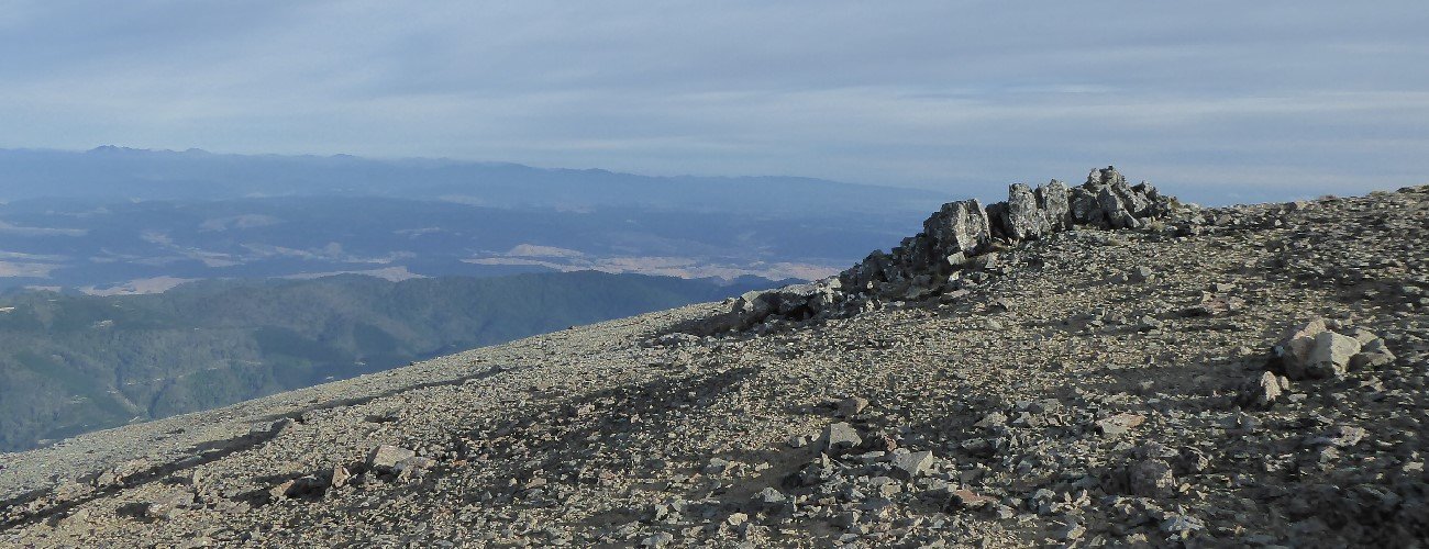
Mt Starveall summit is 2.5 km from Starveall Hut. To reach the summit, continue east up the spur from the hut. The track climbs over rocky outcrops and passes through patches of stunted mountain beech and tussock, and joins the northern end of the summit ridge. Te Araroa Trail does not reach Starveall summit and instead descends to the south east along a forested ridge toward Slaty Peak and Slaty Hut (5.1 km, 2-3 hr away). Do not follow it; instead, deviate to the right along the well-worn path through the tussock. The official summit of Mt Starveall (1511 m) is not the highest point, so continue south along the ridge for 300 m to reach the true summit (1528 m). Travel along the summit ridge is easy-going through tussock, short alpine shrubs and open rocky patches. The summit offers amazing views southwest towards the impressive Mt Rintoul, south toward the Inland Kaikoura Ranges and west across the Waimea Plains.
Mt Starveall is an alpine environment, so proper preparation and care should be made to ensure a safe trip. The track reaches a high elevation and is exposed above the treeline, so proper outdoor clothing is essential. You must always be prepared for freezing conditions and take extreme care if snow and ice and are present. Do not rely on the Nelson weather forecast as the alpine conditions in Mt Richmond Forest Park are likely to be drastically different.
See the Mountain Safety Council website for useful information on preparing for the outdoors.
Mt Starveall (1511 m) is located at the southern end of Bryant Range, in Mt Richmond Forest Park. The gut-busting 930 m climb from Hacket Hut to Starveall Hut forms part of the Richmond Alpine section of the Te Araroa Trail, and is great as a challenging overnight trip or as part of a multi-day tramp. Starveall Hut is located a few kilometers below Mt Starveall summit. Mt Starveall is named after the experience of a stockman, who in the mid 1800s was searching the Richmond Ranges for a suitable route to drive sheep from Nelson to Wairau Valley. After leading his stock to the summit of Mt Starveall he found that they were unable to consume any of the alpine vegetation, and declared that the mountain would ‘starve all’ of his flock.
| Details | |
| Length | 11.3 km Hacket car park to Starveall Hut; 5.7 km Hacket Hut to Starveall Hut; 9.1 km Browning Hut to Starveall Hut; 5.1 km Starveall Hut to Slaty Hut |
| Time Required | 6-7 hr Hacket car park to Starveall Hut; 4-5 hr Hacket Hut to Starveall Hut; 2-3 hr Starveall Hut to Slaty Hut |
| Trail Type | Tramping track |
| Physical Difficulty | Hard |
| Uses | Walking and trail running |
| Direction | Either |
| Start Elevation | 120 m (Hacket car park) or 250 m (Hacket Hut) |
| Finish Elevation | 1180 m (Starveall Hut) or 1528 m (highest point on summit ridge) |
| Dog Access | Permit required for Mt Richmond Forest Park; see local DOC office |
30 min from Nelson
Mt Starveall is accessed via Hacket Track.
Hacket track begins at Hacket car park, in Aniseed Valley. From Richmond, head south along State Highway 6 and turn left onto Aniseed Valley Rd. Follow the road over Aniseed Hill, and then for a further 8 km up Aniseed Valley, until you see the DOC sign indicating the turnoff to the car park on the right. There are toilets at the car park and a bridge across Roding River, beneath which there is a great swimming hole to cool off in during summer. At the car park bridge you will find an information panel with a map and track details.
Hacket Track bridges Roding River at the car park and heads east up Hacket Valley, following the true right of Hacket Creek through pine forest. A suspension bridge crosses the creek and the road becomes a walking track, continuing on the true left through native bush and crossing into Mt Richmond Forest Park. A short distance later the track enters the Dun Mountain Mineral Belt, where the surrounding vegetation becomes stunted and outcrops of ultramafic rock (namely dunite, rodingite and serpentinite) jut out from the hillside above the track. A little further on the track enters pine forestry, which it continues through for the rest of the 2.6 km to Hacket Hut.
Beyond Hacket Hut the track follows Hacket Creek up a forested gully, where there are eight creek crossings, so be prepared to get wet feet. As the DOC signs warn, under no circumstances should you attempt to cross Hacket Creek when it is running high. After 1.5 km the track climbs steeply out of the creek gully and ascends steadily through beech forest.
The track follows a narrow ridge and skirts around Pyramid Rock after 2.8 km, at 660 m elevation. Pyramid Rock is easily missed as it requires a short deviation off the track to see. This roughly marks the halfway point between Hacket Hut and Starveall Hut. The track continues climbing, and there are a few brief steep sections and some boggy bits as small streams are crossed. There is also a bit of windfall in the final few kilometers before the hut. The track zig-zags up the final half-kilometre to the hut.
Starveall Hut is located on a spur coming off the northern end of Mt Starveall. It is positioned next to a rocky slope overlooking a gully to the south and has impressive views of the western face of the mountain.
| Starveall Hut | |
| Hut Type | Standard Hut |
| Capacity | 6 bunks |
| Bookings | Not required; first in, first served |
| Fee | 1 Standard Hut Ticket |
| Altitude | 1180 m |
Mt Starveall summit is 2.5 km from Starveall Hut. To reach the summit, continue east up the spur from the hut. The track climbs over rocky outcrops and passes through patches of stunted mountain beech and tussock, and joins the northern end of the summit ridge. Te Araroa Trail does not reach Starveall summit and instead descends to the south east along a forested ridge toward Slaty Peak and Slaty Hut (5.1 km, 2-3 hr away). Do not follow it; instead, deviate to the right along the well-worn path through the tussock. The official summit of Mt Starveall (1511 m) is not the highest point, so continue south along the ridge for 300 m to reach the true summit (1528 m). Travel along the summit ridge is easy-going through tussock, short alpine shrubs and open rocky patches. The summit offers amazing views southwest towards the impressive Mt Rintoul, south toward the Inland Kaikoura Ranges and west across the Waimea Plains.
Mt Starveall is an alpine environment, so proper preparation and care should be made to ensure a safe trip. The track reaches a high elevation and is exposed above the treeline, so proper outdoor clothing is essential. You must always be prepared for freezing conditions and take extreme care if snow and ice and are present. Do not rely on the Nelson weather forecast as the alpine conditions in Mt Richmond Forest Park are likely to be drastically different.
See the Mountain Safety Council website for useful information on preparing for the outdoors.
Updated 20 February 2019