Rocks Hut is located on the Te Araroa Trail, south of Dun Mountain, in Mount Richmond Forest Park. It is the closest hut to central Nelson (11 km as the crow flies) and is a good destination as an overnighter from Maitai Valley as well as multi-day tramps to Hacket Valley or Pelorus Valley.
| Details | |
| Distances | 12.5 km Maitai Dam to Rocks Hut; 2.8 km Dun Saddle to Rocks Hut |
| Time Required | 4-5 hr from Maitai Dam |
| Trail Type | Shared track/Tramping track |
| Physical Difficulty | Moderate |
| Uses | Walking and trail running |
| Direction | Either |
| Start Elevation | 120 m (Maitai Dam) |
| Max Elevation | 810 m (Rocks Hut) |
| Dog Access | Dogs are prohibited in Maitai Water Reserve |
If any layers fail to load, try clearing your cache and refreshing the page.
20 min from central Nelson
For overnight tramps, Rocks Hut is most-easily accessed via Coppermine Trail, which is 11 km up Maitai Valley Road from central Nelson. Use the car park just after Maungatapu Road turnoff, or if the gate is open, continue to the car park on the other side of the dam spillway. Take note of the signage that warns the gate will be closed at 5 PM.
From Maitai Dam
Begin at the car park at Maitai Valley Road end and follow Coppermine Trail. The first 3.3 km climbs gently alongside Maitai River South Branch, before bridging it and entering the mineral belt. The trail zig-zags steadily upwards through stunted vegetation featuring southern rata, manuka and lancewoods, and mineral-rich rocks, before leveling off and sidling the western flank of Dun Mountain. After 8.7 km the track forks; take the left fork and climb to Dun Saddle. Dun Saddle (955 m) marks the boundary between the Maitai Water Reserve and Mt Richmond Forest Park. The saddle is bare, with only a few tufts of tussock amid the bare gravel and rock outcrops.
From Dun Saddle the track descends gently southwest along a broad ridge, stepping down though tussock and rocky outcrops. The ridge is quite boggy in sections, so blocks of wood have been laid down on parts of the track to allow easy crossing. Rocks Hut is 1 hr (2.8 km) from Dun Saddle.
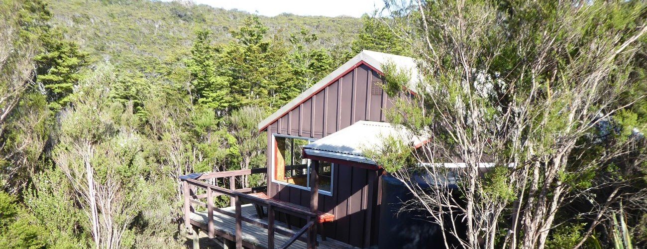
Rocks Hut is named after nearby outcrops on the ridge called The Rocks. A deck extends around the western and southern sides of the hut, and there is a rainwater tank and basin on the exterior. The hut also has the luxury of a flushing toilet, which has views toward Mt Richmond. A short track to a lookout starts close the hut. The lookout provides good views west across the mineral belt.
| Rocks Hut | |
| Hut Type | Standard Hut |
| Capacity | 16 bunks |
| Bookings | Not required; first in, first served |
| Fee | 1 Standard Hut Ticket |
| Altitude | 810 m |
Rocks Hut to Middy Hut (4.8 km, 1 hr 30 min)
The track to Middy Hut (Te Araroa Trail) begins immediately after Rocks Hut. The track steadily descends the eastern side of the ridge. You will reach the junction with Pelorus Track on the hillside not too far from the valley floor; here you can turn right to head to Roebuck Hut (3 hr away). To get to Middy Hut, turn left and descend to the swingbridge that crosses Pelorus River just upstream of the hut; the latter is positioned on the true right bank of the river. The Pelorus Valley road end (Maungatapu Rd) is a further 14.1 km away (via Captain Creek Hut).
Rocks Hut to Browning Hut (10.7 km, 5-6 hr)
Te Araroa Trail continues southwest from Rocks Hut toward Totara Saddle and Browning Hut. The track follows the crest of the broad ridge, climbing up and around a series of knobs through forest featuring a mix of beech, Hall’s totara and celery pine. You will encounter a couple of sections where the forest has been significantly damaged by severe wind events.
While mainly undulating, the track climbs gradually around the highest point on the ridge, 1030 m, then descends through a section of mineral belt tussock, which allows good views towards Mt Starveall. The track then drops to Totara saddle, where you will reach the junction with Pelorus Track. Browning Hut is a short descent from the saddle.


Rocks Hut is located on the Te Araroa Trail, south of Dun Mountain, in Mount Richmond Forest Park. It is the closest hut to central Nelson (11 km as the crow flies) and is a good destination as an overnighter from Maitai Valley as well as multi-day tramps to Hacket Valley or Pelorus Valley.
| Details | |
| Distances | 12.5 km Maitai Dam to Rocks Hut; 2.8 km Dun Saddle to Rocks Hut |
| Time Required | 4-5 hr from Maitai Dam |
| Trail Type | Shared track/Tramping track |
| Physical Difficulty | Moderate |
| Uses | Walking and trail running |
| Direction | Either |
| Start Elevation | 120 m (Maitai Dam) |
| Max Elevation | 810 m (Rocks Hut) |
| Dog Access | Dogs are prohibited in Maitai Water Reserve |
20 min from central Nelson
Rocks Hut is most-easily accessed via Coppermine Trail.
Coppermine Trail is at the end of Maitai Valley (at the Maitai Dam), east of central Nelson. Park at the car park at the road end, which is 11 km up the Maitai Valley from central Nelson. If the gate to the dam is open you can park further up at the car park next to the dam, though take note of the signage that warns the gate will be closed at 5 PM.
Begin at the car park at Maitai Valley Road end and follow Coppermine Trail. The first 3.3 km climbs gently alongside Maitai River South Branch, before bridging it and entering the mineral belt. The trail zig-zags steadily upwards through stunted vegetation featuring southern rata, manuka and lancewoods, and mineral-rich rocks, before leveling off and sidling the western flank of Dun Mountain. After 8.7 km the track forks; take the left fork and climb to Dun Saddle. Dun Saddle (955 m) marks the boundary between the Maitai Water Reserve and Mt Richmond Forest Park. The saddle is bare, with only a few tufts of tussock amid the bare gravel and rock outcrops.
From Dun Saddle the track descends gently southwest along a broad ridge, stepping down though tussock and rocky outcrops. The ridge is quite boggy in sections, so blocks of wood have been laid down on parts of the track to allow easy crossing. Rocks Hut is 1 hr (2.8 km) from Dun Saddle.
Rocks Hut is named after nearby outcrops on the ridge called The Rocks. A deck extends around the western and southern sides of the hut, and there is a rainwater tank and basin on the exterior. The hut also has the luxury of a flushing toilet, which has views toward Mt Richmond. A short track to a lookout starts close the hut. The lookout provides good views west across the mineral belt.
| Rocks Hut | |
| Hut Type | Standard Hut |
| Capacity | 16 bunks |
| Bookings | Not required; first in, first served |
| Fee | 1 Standard Hut Ticket |
| Altitude | 810 m |
Rocks Hut to Middy Hut (4.8 km, 1 hr 30 min)
The track to Middy Hut (Te Araroa Trail) begins immediately after Rocks Hut. The track steadily descends the eastern side of the ridge. You will reach the junction with Pelorus Track on the hillside not too far from the valley floor; here you can turn right to head to Roebuck Hut (3 hr away). To get to Middy Hut, turn left and descend to the swingbridge that crosses Pelorus River just upstream of the hut; the latter is positioned on the true right bank of the river. The Pelorus Valley road end (Maungatapu Rd) is a further 14.1 km away (via Captain Creek Hut).
Rocks Hut to Browning Hut (10.7 km, 5-6 hr)
Te Araroa Trail continues southwest from Rocks Hut toward Totara Saddle and Browning Hut. The track follows the crest of the broad ridge, climbing up and around a series of knobs through forest featuring a mix of beech, Hall’s totara and celery pine. You will encounter a couple of sections where the forest has been significantly damaged by severe wind events.
While mainly undulating, the track climbs gradually around the highest point on the ridge, 1030 m, then descends through a section of mineral belt tussock, which allows good views towards Mt Starveall. The track then drops to Totara saddle, where you will reach the junction with Pelorus Track. Browning Hut is a short descent from the saddle.
Updated 05 March 2023