Mt Hope (1244 m) is a peak on the Hope Range, located in Kahurangi National Park, northwest of Kawatiri Junction. An unofficial but well-marked route leads to the summit from the side of State Highway 6.
| Details | |
| Length | 11.2 km return |
| Time Required | 5-6 hr return |
| Trail Type | Unofficial route |
| Physical Difficulty | Hard |
| Uses | Walking |
| Start Elevation | 380 m |
| Max Elevation | 1244 m |
If any layers fail to load, try clearing your cache and refreshing the page.
Mt Hope Route is not an official route does not connect to any other official tracks.
1 hr from Nelson
Head south from Nelson along State Highway 6. Cross Hope Saddle and approx. 4 min past the turnoff to Tadmor-Glenhope Rd at Glenhope, you’ll reach the state highway bridge across Boulder Stream. The route starts on the side of northbound lane of the highway here. Note that the bridge is inconspicuous and there is no sign to indicate the route; just a small grassed area immediately prior to the bridge guardrail on alongside the northbound lane.
The route, marked by orange plastic triangles, begins as a vehicle track through broom and blackberry, before quickly climbing steeply up a spur through forest mainly consisting of red, hard and silver beech, with a scattering of podocarps like halls totara and miro. After approx. 2 km the gradient of the spur lessens, and the surrounding bush transitions to a coarser, shorter mix of kanuka, yellow silver pine and celery pine.
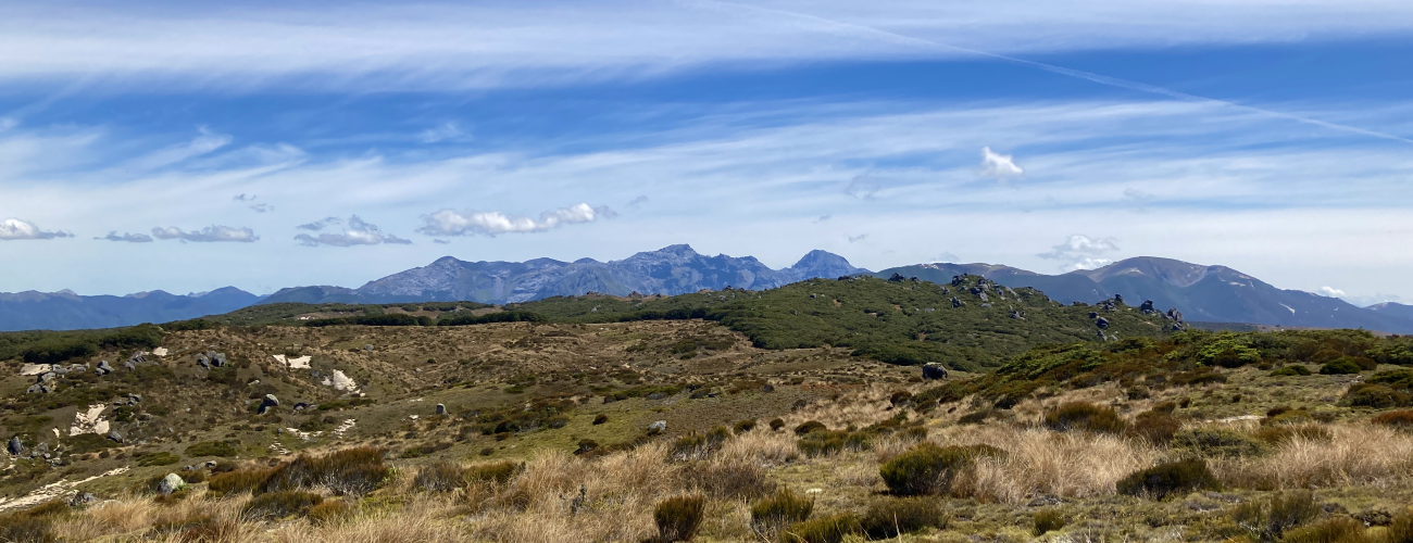
At 1000 m elevation, you’ll reach the beginning of the ‘tops’, which are an undulating mix of stunted mountain beech and kanuka, and tussock and sub-alpine scrub. The track is sandy underfoot, indicative of the underlying granite geology. The route continues to the left (southwest), climbing through patchy mountain beech and passing the intriguingly-shaped granite boulders that dot the landscape. Towards the summit the route markers are less frequent; there is a lightly-worn path through the subalpine scrub though in places it’s a case of picking your own way. The summit is not immediately obvious, though you should aim for the visibly highest point. The summit is marked by a metal pipe trig and small cairn.
The undulating downs topography of the Hope Range can be explored. There are no official routes, though travel is generally straight-forward in clear conditions.
Return the way you came.
This route up Mt Hope is not official and is therefore not maintained by DOC. There is no guarantee that the route will be passable and its condition may deteriorate over time. You should only attempt it if you have good outdoor navigation skills and equipment. The open tops of the Hope Range are a subalpine environment, so proper preparation and care should be made to ensure a safe trip. The route reaches a high elevation and is exposed above the tree line, so proper outdoor clothing is essential. You must always be prepared for freezing conditions and take extreme care if snow and ice and are present. Make sure you carry plenty of water with you as there are no water sources on the way up.
See the Mountain Safety Council website for useful information on preparing for the outdoors.


Mt Hope (1244 m) is a peak on the Hope Range, located in Kahurangi National Park, northwest of Kawatiri Junction. An unofficial but well-marked route leads to the summit from the side of State Highway 6.
| Details | |
| Length | 11.2 km return |
| Time Required | 5-6 hr return |
| Trail Type | Unofficial route |
| Physical Difficulty | Hard |
| Uses | Walking |
| Start Elevation | 380 m |
| Max Elevation | 1244 m |
1 hr from Nelson
Head south from Nelson along State Highway 6. Cross Hope Saddle and approx. 4 min past the turnoff to Tadmor-Glenhope Rd at Glenhope, you’ll reach the state highway bridge across Boulder Stream. The route starts on the side of northbound lane of the highway here. Note that the bridge is inconspicuous and there is no sign to indicate the route; just a small grassed area immediately prior to the bridge guardrail on alongside the northbound lane.
The route, marked by orange plastic triangles, begins as a vehicle track through broom and blackberry, before quickly climbing steeply up a spur through forest mainly consisting of red, hard and silver beech, with a scattering of podocarps like halls totara and miro. After approx. 2 km the gradient of the spur lessens, and the surrounding bush transitions to a coarser, shorter mix of kanuka, yellow silver pine and celery pine.
At 1000 m elevation, you’ll reach the beginning of the ‘tops’, which are an undulating mix of stunted mountain beech and kanuka, and tussock and sub-alpine scrub. The track is sandy underfoot, indicative of the underlying granite geology. The route continues to the left (southwest), climbing through patchy mountain beech and passing the intriguingly-shaped granite boulders that dot the landscape. Towards the summit the route markers are less frequent; there is a lightly-worn path through the subalpine scrub though in places it’s a case of picking your own way. The summit is not immediately obvious, though you should aim for the visibly highest point. The summit is marked by a metal pipe trig and small cairn.
The undulating downs topography of the Hope Range can be explored. There are no official routes, though travel is generally straight-forward in clear conditions.
Return the way you came.
This route up Mt Hope is not official and is therefore not maintained by DOC. There is no guarantee that the route will be passable and its condition may deteriorate over time. You should only attempt it if you have good outdoor navigation skills and equipment. The open tops of the Hope Range are a subalpine environment, so proper preparation and care should be made to ensure a safe trip. The route reaches a high elevation and is exposed above the tree line, so proper outdoor clothing is essential. You must always be prepared for freezing conditions and take extreme care if snow and ice and are present. Make sure you carry plenty of water with you as there are no water sources on the way up.
See the Mountain Safety Council website for useful information on preparing for the outdoors.
Mt Hope Route is not an official route does not connect to any other official tracks.
Updated 4 January 2023