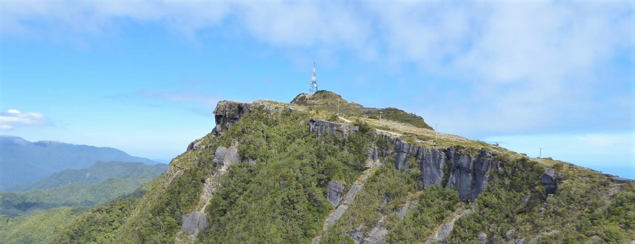
Mt Rochfort (1040 m) is located at the southern end of Denniston Plateau and overlooks Westport and the Buller coastal plain. The summit hosts a transmission tower and is serviced by a 4WD road that traverses the historic coalfields of the Denniston Plateau. Mt Rochfort was named by Julius von Haast after John Rochfort (1832-93), a surveyor-engineer who was involved in exploration and mineral surveys of the Buller District.
| Details | |
| Length | 20.6 km return from Denniston Museum; 40.5 km return from Waimangaroa |
| Time Required | 2-3 hr return from Denniston; 3-4 hr return from Waimangaroa (MTB) |
| Trail Type | 4WD road |
| Physical Difficulty | Moderate (from Denniston) or Hard (from Waimangaroa) |
| Uses | Trail running and MTB |
| Direction | Return (up and down) |
| Start Elevation | 600 m (Denniston) or 20 m (Waimangaroa) |
| Max Elevation | 1040 m |
If any layers fail to load, try clearing your cache and refreshing the page.
There are several MTB tracks that begin from Whatearea Mine Road. Look out for their signposts.
40 min from Westport (Denniston)
From Westport, head north along SH67 for 15 km to Waimangaroa and turn right at the signposted turnoff. If you’re really keen you can park here and begin your ride; otherwise continue along Denniston Road as it winds steeply up the plateau.
Once on top of the plateau, you can turn left and park at the main Brakehead car park. Otherwise, continue a short distance further up the plateau and turn right onto Whareatea Mine Road, where you’ll see a small parking bay immediately on the right.
Whareatea Mine Rd starts sealed but soon becomes a wide gravel road, heading south across the undulating plateau. The landscape and large areas of it are capped with slabs of sandstone, which often resemble man-made pavement. The plateau is largely devoid of vegetation of significant height, with the latter mainly restricted to the deep, narrow gullies the numerous small streams have incised. This exposure allows expansive views north toward the Stockton Plateau and east toward Mt William. The craggy knob of the summit of Mt Rochfort can be seen ahead in the distance; the distance across the ancient plateau means the climb to the summit is deceptively large.
Numerous unnamed 4WD roads and tracks branch off Whareatea Mine Rd. You will also see the signposted beginnings of some MTB tracks that branch off. You will reach the turnoff to Whareatea Mine after 3.5 km, at which point you turn onto the road that continues to the right (a DOC sign indicates Mt Rochfort is this way).
Beyond this turnoff the road is noticeably rougher, with ruts, slabs of exposed bedrock, and deep gravel making the going tough in places. There is a short, steep climb immediately after V40 Stream, though the going is generally undulating for the next kilometre. Trent Stream culvert is crossed at the 5 km mark; this is where the bulk of the ascent to the summit begins as the plateau tilts upwards to the southeast. The road climbs steadily upwards at a 10% grade for 1.5 km before dipping to the rocky headwaters of Conglomerate Creek, where you will see impressive rocky knobs. The road rounds the gully and climbs steeply out of it, before continuing at a steady incline.
About 800 m from the summit the road reaches the southeastern extent of the plateau, where rocky sandstone bluffs drop dramatically into the forested valleys of the Cascade Creek catchment. The road winds up the final distance to the transmission tower. Next to it is the trig, positioned atop a fractured outcrop. You will enjoy impressive views north along the Karamea Bight, all the way to the forested Heaphy Coast, and south towards the rugged peaks of the Paparoas.
Return the way you came.
The Denniston Plateau has been heavily mined and prospected since the latter half of the 1800s. Do not deviate off the road as hazardous features like mine shafts and rusty mining equipment may be present. As the ridge narrows towards the summit of Mt Rochfort, there are high bluffs that drop off to the east. The road is public all the way to the summit, so be wary of encountering other vehicles.
The plateau is renowned for having a bleak climate, with heavy rain and fog frequent. Snow is an annual occurrence in winter. The temperature can be significantly cooler than on the coast, and the lack of vegetation significantly increases exposure. Accordingly, make sure you carry appropriate outdoor layers with you. Mobile reception is available in most places along the road to Mt Rochfort.


Mt Rochfort (1040 m) is located at the southern end of Denniston Plateau and overlooks Westport and the Buller coastal plain. The summit hosts a transmission tower and is serviced by a 4WD road that traverses the historic coalfields of the Denniston Plateau. Mt Rochfort was named by Julius von Haast after John Rochfort (1832-93), a surveyor-engineer who was involved in exploration and mineral surveys of the Buller District.
| Details | |
| Length | 20.6 km return from Denniston Museum; 40.5 km return from Waimangaroa |
| Time Required | 2-3 hr return from Denniston; 3-4 hr return from Waimangaroa (MTB) |
| Trail Type | 4WD road |
| Physical Difficulty | Moderate (from Denniston) or Hard (from Waimangaroa) |
| Uses | Trail running and MTB |
| Direction | Return (up and down) |
| Start Elevation | 600 m (Denniston) or 20 m (Waimangaroa) |
| Max Elevation | 1040 m |
40 min from Westport (Denniston)
From Westport, head north along SH67 for 15 km to Waimangaroa and turn right at the signposted turnoff. If you’re really keen you can park here and begin your ride; otherwise continue along Denniston Road as it winds steeply up the plateau.
Once on top of the plateau, you can turn left and park at the main Brakehead car park. Otherwise, continue a short distance further up the plateau and turn right onto Whareatea Mine Road, where you’ll see a small parking bay immediately on the right.
Whareatea Mine Rd starts sealed but soon becomes a wide gravel road, heading south across the undulating plateau. The landscape and large areas of it are capped with slabs of sandstone, which often resemble man-made pavement. The plateau is largely devoid of vegetation of significant height, with the latter mainly restricted to the deep, narrow gullies the numerous small streams have incised. This exposure allows expansive views north toward the Stockton Plateau and east toward Mt William. The craggy knob of the summit of Mt Rochfort can be seen ahead in the distance; the distance across the ancient plateau means the climb to the summit is deceptively large.
Numerous unnamed 4WD roads and tracks branch off Whareatea Mine Rd. You will also see the signposted beginnings of some MTB tracks that branch off. You will reach the turnoff to Whareatea Mine after 3.5 km, at which point you turn onto the road that continues to the right (a DOC sign indicates Mt Rochfort is this way).
Beyond this turnoff the road is noticeably rougher, with ruts, slabs of exposed bedrock, and deep gravel making the going tough in places. There is a short, steep climb immediately after V40 Stream, though the going is generally undulating for the next kilometre. Trent Stream culvert is crossed at the 5 km mark; this is where the bulk of the ascent to the summit begins as the plateau tilts upwards to the southeast. The road climbs steadily upwards at a 10% grade for 1.5 km before dipping to the rocky headwaters of Conglomerate Creek, where you will see impressive rocky knobs. The road rounds the gully and climbs steeply out of it, before continuing at a steady incline.
About 800 m from the summit the road reaches the southeastern extent of the plateau, where rocky sandstone bluffs drop dramatically into the forested valleys of the Cascade Creek catchment. The road winds up the final distance to the transmission tower. Next to it is the trig, positioned atop a fractured outcrop. You will enjoy impressive views north along the Karamea Bight, all the way to the forested Heaphy Coast, and south towards the rugged peaks of the Paparoas.
Return the way you came.
The Denniston Plateau has been heavily mined and prospected since the latter half of the 1800s. Do not deviate off the road as hazardous features like mine shafts and rusty mining equipment may be present. As the ridge narrows towards the summit of Mt Rochfort, there are high bluffs that drop off to the east. The road is public all the way to the summit, so be wary of encountering other vehicles.
The plateau is renowned for having a bleak climate, with heavy rain and fog frequent. Snow is an annual occurrence in winter. The temperature can be significantly cooler than on the coast, and the lack of vegetation significantly increases exposure. Accordingly, make sure you carry appropriate outdoor layers with you. Mobile reception is available in most places along the road to Mt Rochfort.
There are several MTB tracks that begin from Whatearea Mine Road. Look out for their signposts.
Updated 26 June 2020