St James Walkway is a 65 kilometre tramping track located in the mountains of the Lewis Pass. Typically completed in four days, the walkway provides a multi-day mountain wilderness experience, and its lack of high mountain passes or particularly challenging terrain means it’s a great entry-level option. Part of the walkway also doubles as the Te Araroa Trail.
| Details | |
| Distances | 65 km full length; 7.6 km Lewis Pass (SH7) to Cannibal Gorge Hut; 3.9 km Cannibal Gorge Hut to Ada Pass Hut; 11 km Ada Pass Hut to Christopher Hut; 12.7 km Christopher Hut to Anne Hut; 16.6 km Anne Hut to Boyle Flat Hut; 12.6 km Boyle Flat Hut to Boyle Village (SH7) |
| Time Required | 3-5 days |
| Trail Type | Tramping track |
| Physical Difficulty | Moderate |
| Uses | Walking and trail running |
| Direction | Either |
If any layers fail to load, try clearing your cache and refreshing the page.
St James Cycleway (via Saddle Spur)
Walking and trail running
Waiau Track (Te Araroa Trail)
Walking and trail running
St James Walkway traverses through mountainous terrain where severe weather can occur at any time of year. Therefore you must always be prepared for freezing and wet conditions. Most major rivers and streams are bridged, though some smaller ones aren’t and may be impassable following rain. Sections of the track between Lewis Pass and Christopher Hut cross avalanche paths which can pose a risk in winter and spring. Parts of the walkway offer very little shade, so make sure you carry appropriate sun protection in summer. None of the huts are bookable and you may find that they are full when you arrive; therefore it would be wise to carry camping equipment during the busier times of year.
See the Mountain Safety Council website for useful information on preparing for the outdoors.


20 min from Springs Junction | 35 min from Hanmer Springs turnoff
Both ends of St James Walkway connect with State Highway 7, the primary highway route between Nelson and Christchurch. The respective ends of the walkway are approx. 15 min (16 km) drive apart, and there is no formal foot track between the two, meaning transport logistics must be planned prior. There are DOC car parks at each end, though these are unsecure and track users leave vehicles at the own risk. Most walkers complete the track in a clockwise direction (starting at Lewis Pass and finishing at Boyle Village) as this is the easier direction (slightly downhill overall).
Boyle River Outdoor Education Centre, located at the Boyle Village end of the track, offers paid parking (more secure) as well as car relocation and shuttle services.
St James Walkway was opened in 1981 and was part of the New Zealand Walkway System, which was an envisaged network of connected walkways that would span the length of New Zealand (somewhat of a precursor to the Te Araroa Trail). It was the first walk in the system to be both multi-day and also located in a high country (subalpine) area.
The walkway straddles the Lewis Pass Scenic Reserve and the St James Conservation Area.
| Distance | 11.5 km |
| Time Required | 4-5 hr |
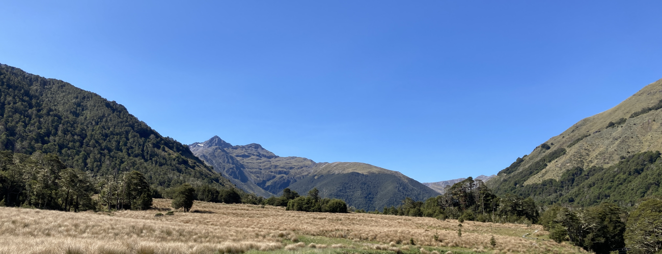
The walkway begins at the Lewis Pass car park next to SH7, initially passing through subalpine scrub and mountain beech before dropping into the valley of the Maruia River Right Branch, where a swing bridge crosses the river and a sign details the origin of Cannibal Gorge’s intriguing name. The track undulates pleasantly through beech forest as it heads north up the valley on the true right side of the river. Several side streams and debris chutes are crossed along the way. Cannibal Gorge Hut is positioned at the end of a meadow next to the river, with an unnamed 1911 m elevation peak providing a spectacular backdrop.
| Cannibal Gorge Hut | |
| Hut Type | Serviced Hut |
| Capacity | 20 bunks |
| Bookings | Not required; first in, first served |
| Fee | 1 Serviced Hut Ticket |
| Elevation | 890 m |
The track continues north up the valley through beech forest and meadow sections, climbing at a gentle rate to Ada Pass Hut which is located near Ada Pass (1008 m). The deck of the hut provides a nice view north towards Three Tarns Pass (where an unofficial route leads to the Matakitaki Valley).
| Ada Pass Hut | |
| Hut Type | Serviced Hut |
| Capacity | 14 bunks |
| Bookings | Not required; first in, first served |
| Fee | 1 Serviced Hut Ticket |
| Elevation | 1006 m |
| Distances | 23.7 km |
| Time Required | 7-9 hr |
From Ada Pass Hut, the track continues through mountain beech before emerging onto grassy flats heading in a northeasterly direction down the Ada River valley, having now crossed the subtle divide that is Ada Pass and entered the wider Waiau Uwha catchment. The dramatic Spenser Mountains loom high on the left, providing plenty of spectacular views (though also avalanche risk in winter and spring; pay attention to the warning signs). After roughly 7 km the valley makes a turn to the southeast and soon after you’ll reach Christopher Cullers Hut (built in 1956) and roughly 1 km later Christopher Hut, positioned on the forest edge on the southern side of the valley. Here a connecting track branches off, crossing the Ada River and heading down its true left to join with the Waiau Valley Track further down the valley.
| Christopher Hut | |
| Hut Type | Serviced Hut |
| Capacity | 14 bunks |
| Bookings | Not required; first in, first served |
| Fee | 1 Serviced Hut Ticket |
| Elevation | 800 m |
From Christopher Hut the track continues across grassy river flats and through patches of matagouri, rounding the bottom slopes of Mt Federation on the true right of the Ada River.
Across the river is the historic Ada Homestead, made obvious by the tall exotic trees that surround it. The homestead and associated buildings were built between between 1879 and 1896. The original Ada run is one of several neighbouring runs amalgamated to form the 78,196 ha St James Station. The station was bought by the crown in 2008, after which it became St James Conservation Area under the management of DOC.
The Ada River valley converges with the north-south running Waiau Uwha valley and as the track rounds the toe of Mt Federation, it gradually turns to the southwest. The St James Walkway reaches a junction with the Waiau Valley Track (Te Araroa Trail), the latter having come from a more direct route down the valley along the true right of the Waiau Uwha River. From this point on the St James Walkway doubles as the Te Araroa Trail. Soon after the track follows a 4WD farm track and before crosses the Henry River via a swing bridge then climbs onto a terrace on which Anne Hut is located.
Anne Hut, built in 2011, is positioned in a curiously exposed position, in the middle of a grassy river terrace several hundred metres from Anne River. This hut replaced its predecessor, which burned down in July 2010 and was located roughly 1.1 km southwest on the opposite side of the Anne River.
| Anne Hut | |
| Hut Type | Serviced Hut |
| Capacity | 20 bunks |
| Bookings | Not required; first in, first served |
| Fee | 1 Serviced Hut Ticket |
| Elevation | 890 m |
| Distance | 16.6 km |
| Time Required | 5-6 hr |
The walkway leaves the hut and continues across the grassy terrace, with views west to the headwaters of the Henry River. The track descends the terrace and turns south, following the Anne River. The track alternates between grassy meadows and beech forest, gradually climbing valley, the floor of which gets boggier as you approach Anne Saddle. The last bit of climbing to Anne Saddle is the steepest part of the entire walkway, and Anne Saddle is its highest point at 1136 m. The track descends the Boyle Valley side, eventually reaching the valley floor and emerging onto grassy river flats, where it heads south on the true left of Boyle River. The somewhat shabby and seldom-stayed-in Rokeby Hut is just off the main walkway. The track continues for a further 3.5 km down the valley to a swing bridge, which crosses Boyle River to reach Boyle Flat Hut, located on a terrace above the true right of the river.
| Boyle Flat Hut | |
| Hut Type | Serviced Hut |
| Capacity | 14 bunks |
| Bookings | Not required; first in, first served |
| Fee | 1 Serviced Hut Ticket |
| Elevation | 800 m |
| Distances | 12.6 km |
| Time Required | 3-4 hr |
The track leaves the meadows and enters a narrower part of the valley for several kilometers, where there are some short steep sections that climb around washouts. Once through this, a junction is reached with the track to Magdalen Hut (approx. 1 km a way; 6 bunks). A swing bridge crosses the Boyle River to the true right, and climbs slightly away from the river. Cattle can be seen grazing the river flats of the Magdalen Valley floor; this is part of the Glenhope Station pastoral lease. The track turns southwest as it rounds the base of the Libretto Range, and then runs parallel to Boyle River again as the valley narrows. Another swing bridge crosses the river, and the walkway continues on the true left for the remainder of the distance to the walkway’s southern end, at Boyle Village.
St James Walkway is a 65 kilometre tramping track located in the mountains of the Lewis Pass. Typically completed in four days, the walkway provides a multi-day mountain wilderness experience, and its lack of high mountain passes or particularly challenging terrain means it’s a great entry-level option. Part of the walkway also doubles as the Te Araroa Trail.
| Details | |
| Distances | 65 km full length; 7.6 km Lewis Pass (SH7) to Cannibal Gorge Hut; 3.9 km Cannibal Gorge Hut to Ada Pass Hut; 11 km Ada Pass Hut to Christopher Hut; 12.7 km Christopher Hut to Anne Hut; 16.6 km Anne Hut to Boyle Flat Hut; 12.6 km Boyle Flat Hut to Boyle Village (SH7) |
| Time Required | 3-5 days |
| Trail Type | Tramping track |
| Physical Difficulty | Moderate |
| Uses | Walking and trail running |
| Direction | Either |
20 min from Springs Junction | 35 min from Hanmer Springs turnoff
Both ends of St James Walkway connect with State Highway 7, the primary highway route between Nelson and Christchurch. The respective ends of the walkway are approx. 15 min (16 km) drive apart, and there is no formal foot track between the two, meaning transport logistics must be planned prior. There are DOC car parks at each end, though these are unsecure and track users leave vehicles at the own risk. Most walkers complete the track in a clockwise direction (starting at Lewis Pass and finishing at Boyle Village) as this is the easier direction (slightly downhill overall).
Boyle River Outdoor Education Centre, located at the Boyle Village end of the track, offers paid parking (more secure) as well as car relocation and shuttle services.
St James Walkway was opened in 1981 and was part of the New Zealand Walkway System, which was an envisaged network of connected walkways that would span the length of New Zealand (somewhat of a precursor to the Te Araroa Trail). It was the first walk in the system to be both multi-day and also located in a high country (subalpine) area.
The walkway straddles the Lewis Pass Scenic Reserve and the St James Conservation Area.
| Distances | 11.5 km |
| Time Required | 3-4 hr |
The walkway begins at the Lewis Pass car park next to SH7, initially passing through subalpine scrub and mountain beech before dropping into the valley of the Maruia River Right Branch, where a swing bridge crosses the river and a sign details the origin of Cannibal Gorge’s intriguing name. The track undulates pleasantly through beech forest as it heads north up the valley on the true right side of the river. Several side streams and debris chutes are crossed along the way. Cannibal Gorge Hut is positioned at the end of a meadow next to the river, with an unnamed 1911 m elevation peak providing a spectacular backdrop.
| Cannibal Gorge Hut | |
| Hut Type | Serviced Hut |
| Capacity | 20 bunks |
| Bookings | Not required; first in, first served |
| Fee | 1 Serviced Hut Ticket |
| Elevation | 890 m |
The track continues north up the valley through beech forest and meadow sections, climbing at a gentle rate to Ada Pass Hut which is located near Ada Pass (1008 m). The deck of the hut provides a nice view north towards Three Tarns Pass (where an unofficial route leads to the Matakitaki Valley).
| Ada Pass Hut | |
| Hut Type | Serviced Hut |
| Capacity | 14 bunks |
| Bookings | Not required; first in, first served |
| Fee | 1 Serviced Hut Ticket |
| Elevation | 1006 m |
| Distance | 23.7 km |
| Time Required | 7-9 hr |
From Ada Pass Hut, the track continues through mountain beech before emerging onto grassy flats heading in a northeasterly direction down the Ada River valley, having now crossed the subtle divide that is Ada Pass and entered the wider Waiau Uwha catchment. The dramatic Spenser Mountains loom high on the left, providing plenty of spectacular views (though also avalanche risk in winter and spring; pay attention to the warning signs). After roughly 7 km the valley makes a turn to the southeast and soon after you’ll reach Christopher Cullers Hut (built in 1956) and roughly 1 km later Christopher Hut, positioned on the forest edge on the southern side of the valley. Here a connecting track branches off, crossing the Ada River and heading down its true left to join with the Waiau Valley Track further down the valley.
| Christopher Hut | |
| Hut Type | Serviced Hut |
| Capacity | 14 bunks |
| Bookings | Not required; first in, first served |
| Fee | 1 Serviced Hut Ticket |
| Elevation | 800 m |
From Christopher Hut the track continues across grassy river flats and through patches of matagouri, rounding the bottom slopes of Mt Federation on the true right of the Ada River.
Across the river is the historic Ada Homestead, made obvious by the tall exotic trees that surround it. The homestead and associated buildings were built between between 1879 and 1896. The original Ada run is one of several neighbouring runs amalgamated to form the 78,196 ha St James Station. The station was bought by the crown in 2008, after which it became St James Conservation Area under the management of DOC.
The Ada River valley converges with the north-south running Waiau Uwha valley and as the track rounds the toe of Mt Federation, it gradually turns to the southwest. The St James Walkway reaches a junction with the Waiau Valley Track (Te Araroa Trail), the latter having come from a more direct route down the valley along the true right of the Waiau Uwha River. From this point on the St James Walkway doubles as the Te Araroa Trail. Soon after the track follows a 4WD farm track and before crosses the Henry River via a swing bridge then climbs onto a terrace on which Anne Hut is located.
Anne Hut, built in 2011, is positioned in a curiously exposed position, in the middle of a grassy river terrace several hundred metres from Anne River. This hut replaced its predecessor, which burned down in July 2010 and was located roughly 1.1 km southwest on the opposite side of the Anne River.
| Anne Hut | |
| Hut Type | Serviced Hut |
| Capacity | 20 bunks |
| Bookings | Not required; first in, first served |
| Fee | 1 Serviced Hut Ticket |
| Elevation | 890 m |
| Distances | 16.6 km |
| Time Required | 5-6 hr |
The walkway leaves the hut and continues across the grassy terrace, with views west to the headwaters of the Henry River. The track descends the terrace and turns south, following the Anne River. The track alternates between grassy meadows and beech forest, gradually climbing valley, the floor of which gets boggier as you approach Anne Saddle. The last bit of climbing to Anne Saddle is the steepest part of the entire walkway, and Anne Saddle is its highest point at 1136 m. The track descends the Boyle Valley side, eventually reaching the valley floor and emerging onto grassy river flats, where it heads south on the true left of Boyle River. The somewhat shabby and seldom-stayed-in Rokeby Hut is just off the main walkway. The track continues for a further 3.5 km down the valley to a swing bridge, which crosses Boyle River to reach Boyle Flat Hut, located on a terrace above the true right of the river.
| Boyle Flat Hut | |
| Hut Type | Serviced Hut |
| Capacity | 14 bunks |
| Bookings | Not required; first in, first served |
| Fee | 1 Serviced Hut Ticket |
| Elevation | 800 m |
| Distances | 12.6 km |
| Time Required | 3-4 hr |
The track leaves the meadows and enters a narrower part of the valley for several kilometers, where there are some short steep sections that climb around washouts. Once through this, a junction is reached with the track to Magdalen Hut (approx. 1 km a way; 6 bunks). A swing bridge crosses the Boyle River to the true right, and climbs slightly away from the river. Cattle can be seen grazing the river flats of the Magdalen Valley floor; this is part of the Glenhope Station pastoral lease. The track turns southwest as it rounds the base of the Libretto Range, and then runs parallel to Boyle River again as the valley narrows. Another swing bridge crosses the river, and the walkway continues on the true left for the remainder of the distance to the walkway’s southern end, at Boyle Village.
St James Walkway traverses through mountainous terrain where severe weather can occur at any time of year. Therefore you must always be prepared for freezing and wet conditions. Most major rivers and streams are bridged, though some smaller ones aren’t and may be impassable following rain. Sections of the track between Lewis Pass and Christopher Hut cross avalanche paths which can pose a risk in winter and spring. Parts of the walkway offer very little shade, so make sure you carry appropriate sun protection in summer. None of the huts are bookable and you may find that they are full when you arrive; therefore it would be wise to carry camping equipment during the busier times of year.
See the Mountain Safety Council website for useful information on preparing for the outdoors.
Waiau Valley Track (Te Araroa Trail)
Walking and trail running
St James Cycle Trail (via Saddle Spur)
Walking and trail running
Updated 19 December 2023