Wainui Hut is located partway along Wainui Track, which runs between Canaan Downs and Birds Clearing, in Abel Tasman National Park. Though it is probably the least-used hut in the park, it is still great as an easy overnight tramp or day walk.
| Details | |
| Distances | 5.6 km Canaan Downs car park to Wainui Hut; 6.8 km Wainui Hut to Birds Clearing |
| Time Required (to Moa Park) | 1 hr 45 min Canaan Downs car park to Wainui Hut; 2 hr Wainui Hut to Birds Clearing |
| Trail Type | Farm track/Tramping track |
| Physical Difficulty | Moderate |
| Uses | Walking and trail running |
| Direction | Either |
| Start Elevation | 750 m (Canaan Downs) |
| Max Elevation | 850 m (Wainui Saddle) |
| Dog Access | Dogs are prohibited in Abel Tasman National Park |
If any layers fail to load, try clearing your cache and refreshing the page.
This elevation profile should be considered approximate. Its accuracy is determined by the quality of data available.
1 hr 30 min from Nelson (Canaan Downs) | 30 min from Takaka (Birds Clearing)
The easiest way to access Wainui Hut is via Canaan Downs. From Nelson, follow State Highway 60 to the top of Takaka Hill. Turn right onto Canaan Road, which is just past the Ngarua Cave turnoff. Canaan Road is unsealed, windy and narrow, so drive with caution. It is 11 km from the turnoff to Canaan Downs car park, which is situated at 750 m elevation. It is also the start point for Harwoods Hole Track, Rameka Track and Canaan Downs MTB tracks.
The northern end of Wainui Track finishes at Birds Clearing, 8.3 km up Bird Road from Clifton. Bird Road gives vehicle access to the track start, which is at 670 m elevation. For extended trail runs, you can run the whole way down Bird Road and connect to the shared pathway that runs between Takaka and Pohara.
For day walkers, note that the distance by car between the respective road ends at Canaan Downs and Birds Clearing is 61 km (1 hr 30 min).
Canaan Downs start
Moa Park Track begins as a farm track, steadily climbing along the forest edge above the farmland of Canaan Downs. Pages Saddle is 1 km from the car park, where Rameka Track forks to the left. After 3 km you will reach Wainui Saddle, where Wainui Track branches off of Moa Park Track (the latter continues up Evans Ridge, connecting with the Inland Track after 1.2 km.
Wainui Track descends into Wainui Valley. The gradient is initially moderate, then reduces to the point of being flat as the track reaches the broad valley floor. Wainui Track is easy-going, though typical of inland Abel Tasman tracks in that it is primarily rough and rooty, with occasional sections of smooth track that allow you to stretch your legs.
The valley is forested in beautiful beech forest, and the track runs parallel to the mossy-banked Wainui River, which gradually increases in flow with distance down the valley. There are several un-bridged creeks that are tricky to cross without getting wet feet.
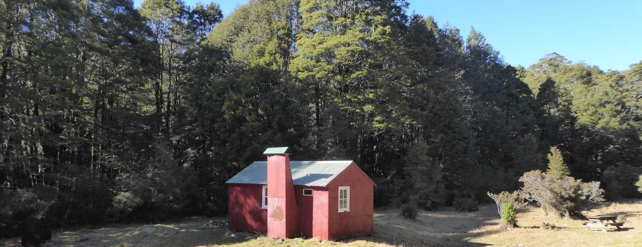
Wainui Hut is positioned in a grassy clearing a short distance from Wainui River. Given the relatively low number of overnight visitors, the hut is only equipped with four bunks, is not insulated and has an open fire that can provide quite a smoky experience. The tall forest surrounding the clearing also prevents much sunlight in winter. Also located in the clearing is an aviary, which is used by Project Janszoon and DOC to acclimatise kaka and kakariki to local conditions for reintroduction to the park.
| Wainui Hut | |
| Hut Type | Standard Hut |
| Capacity | 4 |
| Bookings | Not required; first in, first served |
| Fee | 1 Standard Hut ticket |
| Altitude | 710 m |
Immediately after the hut, the track fords Wainui River; there is no bridge, so the river will be impassable following heavy rain. Now on the true right, Wainui Track continues for 700 m to a track junction. At this junction you can continue straight (north) along Wainui Track to Birds Clearing (1 hr 50 min away), or turn right to climb Evans Ridge and connect with Inland Track (Awapoto Hut is 3 hr 15 min away).
Beyond the track junction, Wainui Track follows the river on the valley floor for a further kilometre, before fording back to the true left and climbing up the western side of the valley. The track continues along the crest of the ridge for two kilometres to an open high point clear of bush. From here it is an easy 1.5 km through scrub and pasture to the track end at Birds Clearing.


Wainui Hut is located partway along Wainui Track, which runs between Canaan Downs and Birds Clearing, in Abel Tasman National Park. Though it is probably the least-used hut in the park, it is still great as an easy overnight tramp or day walk.
| Details | |
| Distances | 5.6 km Canaan Downs car park to Wainui Hut; 6.8 km Wainui Hut to Birds Clearing |
| Time Required (to Moa Park) | 1 hr 45 min Canaan Downs car park to Wainui Hut; 2 hr Wainui Hut to Birds Clearing |
| Trail Type | Farm track/Tramping track |
| Physical Difficulty | Moderate |
| Uses | Walking and trail running |
| Direction | Either |
| Start Elevation | 750 m (Canaan Downs) |
| Max Elevation | 850 m (Wainui Saddle) |
| Dog Access | Dogs are prohibited in Abel Tasman National Park |
1 hr 30 min from Nelson (Canaan Downs) | 30 min from Takaka (Birds Clearing)
The easiest way to access Wainui Hut is via Canaan Downs. From Nelson, follow State Highway 60 to the top of Takaka Hill. Turn right onto Canaan Road, which is just past the Ngarua Cave turnoff. Canaan Road is unsealed, windy and narrow, so drive with caution. It is 11 km from the turnoff to Canaan Downs car park, which is situated at 750 m elevation. It is also the start point for Harwoods Hole Track, Rameka Track and Canaan Downs MTB tracks.
The northern end of Wainui Track finishes at Birds Clearing, 8.3 km up Bird Road from Clifton. Bird Road gives vehicle access to the track start, which is at 670 m elevation. For extended trail runs, you can run the whole way down Bird Road and connect to the shared pathway that runs between Takaka and Pohara.
For day walkers, note that the distance by car between the respective road ends at Canaan Downs and Birds Clearing is 61 km (1 hr 30 min).
Moa Park Track begins as a farm track, steadily climbing along the forest edge above the farmland of Canaan Downs. Pages Saddle is 1 km from the car park, where Rameka Track forks to the left. After 3 km you will reach Wainui Saddle, where Wainui Track branches off of Moa Park Track (the latter continues up Evans Ridge, connecting with the Inland Track after 1.2 km.
Wainui Track descends into Wainui Valley. The gradient is initially moderate, then reduces to the point of being flat as the track reaches the broad valley floor. Wainui Track is easy-going, though typical of inland Abel Tasman tracks in that it is primarily rough and rooty, with occasional sections of smooth track that allow you to stretch your legs.
The valley is forested in beautiful beech forest, and the track runs parallel to the mossy-banked Wainui River, which gradually increases in flow with distance down the valley. There are several un-bridged creeks that are tricky to cross without getting wet feet.
Wainui Hut is positioned in a grassy clearing a short distance from Wainui River. Given the relatively low number of overnight visitors, the hut is only equipped with four bunks, is not insulated and has an open fire that can provide quite a smoky experience. The tall forest surrounding the clearing also prevents much sunlight in winter. Also located in the clearing is an aviary, which is used by Project Janszoon and DOC to acclimatise kaka and kakariki to local conditions for reintroduction to the park.
| Wainui Hut | |
| Hut Type | Standard Hut |
| Capacity | 4 |
| Bookings | Not required; first in, first served |
| Fee | 1 Standard Hut ticket |
| Altitude | 710 m |
Immediately after the hut, the track fords Wainui River; there is no bridge, so the river will be impassable following heavy rain. Now on the true right, Wainui Track continues for 700 m to a track junction. At this junction you can continue straight (north) along Wainui Track to Birds Clearing (1 hr 50 min away), or turn right to climb Evans Ridge and connect with Inland Track (Awapoto Hut is 3 hr 15 min away).
Beyond the track junction, Wainui Track follows the river on the valley floor for a further kilometre, before fording back to the true left and climbing up the western side of the valley. The track continues along the crest of the ridge for two kilometres to an open high point clear of bush. From here it is an easy 1.5 km through scrub and pasture to the track end at Birds Clearing.
Updated 10 August 2020