Trig K Circuit climbs to the 417 m elevation summit of Trig K, located immediately behind Pelorus Bridge in the Pelorus Bridge Scenic Reserve. The circuit climbs through beautiful beech-podocarp forest and provides good views at the summit.
| Details | |
| Length | 6.7 km return to car park |
| Time Required | 3-4 hr |
| Trail Type | Walking track/Tramping track |
| Physical Difficulty | Moderate |
| Uses | Walking and trail running |
| Direction | Either |
| Start Elevation | 30 m |
| Max Elevation | 417 m |
If any layers fail to load, try clearing your cache and refreshing the page.
This elevation profile should be considered approximate. Its accuracy is determined by the quality of data available.
45 min from Nelson | 40 min from Blenheim
Pelorus Bridge is a 45 min drive along State Highway 6 from Nelson, via Whangamoa and Rai saddles. From Blenheim, it is a 40 min drive, also along State Highway 6.
Pelorus Bridge has parking on either side of the highway, as well as toilets and a cafe. There are useful DOC maps and information panels detailing the ecology and history of the area. All tracks are well-signposted.
Trig K Circuit begins at the end of Tawa Path, which is a short wheelchair-friendly walkway beginning at the car park next to the cafe. Tawa Path passes beneath some of the most magnificent rimu and kahikatea specimens you will ever see, with some reaching over 40 m in height.
A tramping track continues beyond the furthest point of Tawa Path and after a short distance you will reach the junction between the respective ends of Trig K Circuit. The circuit can be walked in either direction and you will loop back to this junction whichever way you go. Heading right at the junction (alongside the river) is the way to Elvy Stream Waterfall (45 min away).
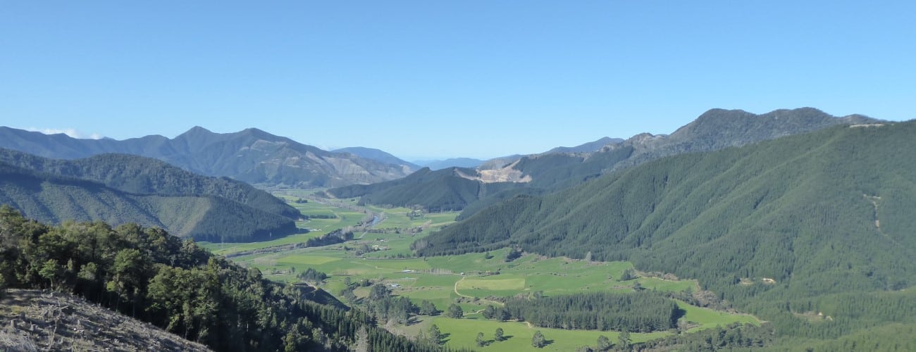
Heading left from the junction, the track climbs gently up the hill, zig-zagging upwards through beech, rimu and ferns. After 45 min of climbing you’ll reach the top of the ridge on the edge of felled block of pine forest and a short climb later you’ll be at the Trig K summit (417 m). Enjoy the clear views down Pelorus Valley and Rai Valley and across to the forested peak of Benbown.
The track continues over the summit and descends gradually down the other side, following a broad spur. Near the valley floor Elvy Stream Waterfall is a short deviation to the left, beneath which is a small pool you can immerse yourself in in summer (if there is enough water flowing). The track heads back alongside the true right of Pelorus River, eventually linking back to junction where you turned uphill at the start of the circuit.


Trig K Circuit climbs to the 417 m elevation summit of Trig K, located immediately behind Pelorus Bridge in the Pelorus Bridge Scenic Reserve. The circuit climbs through beautiful beech-podocarp forest and provides good views at the summit.
| Details | |
| Length | 6.7 km return to car park |
| Time Required | 3-4 hr |
| Trail Type | Walking track/Tramping track |
| Physical Difficulty | Moderate |
| Uses | Walking and trail running |
| Direction | Either |
| Start Elevation | 30 m |
| Max Elevation | 417 m |
45 min from Nelson | 40 min from Blenheim
Pelorus Bridge is a 45 min drive along State Highway 6 from Nelson, via Whangamoa and Rai saddles. From Blenheim, it is a 40 min drive, also along State Highway 6.
Pelorus Bridge has parking on either side of the highway, as well as toilets and a cafe. There are useful DOC maps and information panels detailing the ecology and history of the area. All tracks are well-signposted.
Trig K Circuit begins at the end of Tawa Path, which is a short wheelchair-friendly walkway beginning at the car park next to the cafe. Tawa Path passes beneath some of the most magnificent rimu and kahikatea specimens you will ever see, with some reaching over 40 m in height.
A tramping track continues beyond the furthest point of Tawa Path and after a short distance you will reach the junction between the respective ends of Trig K Circuit. The circuit can be walked in either direction and you will loop back to this junction whichever way you go. Heading right at the junction (alongside the river) is the way to Elvy Stream Waterfall (45 min away).
Heading left from the junction, the track climbs gently up the hill, zig-zagging upwards through beech, rimu and ferns. After 45 min of climbing you’ll reach the top of the ridge on the edge of felled block of pine forest and a short climb later you’ll be at the Trig K summit (417 m). Enjoy the clear views down Pelorus Valley and Rai Valley and across to the forested peak of Benbown.
The track continues over the summit and descends gradually down the other side, following a broad spur. Near the valley floor Elvy Stream Waterfall is a short deviation to the left, beneath which is a small pool you can immerse yourself in in summer (if there is enough water flowing). The track heads back alongside the true right of Pelorus River, eventually linking back to junction where you turned uphill at the start of the circuit.
Updated 12 September 2020